The BBC website has a very effective mapping tool for understanding just how pervasive and violent the ethnic cleansing campaigns of both the Shia and the Sunnis in Baghdad have become. The tool is also useful for understanding possible operational and tactical reasons for the wall US authorities want to build around a Sunni dominated neighborhood east of the Tigris.
Below is a map of ethnic communities in Baghdad prior to 2006.
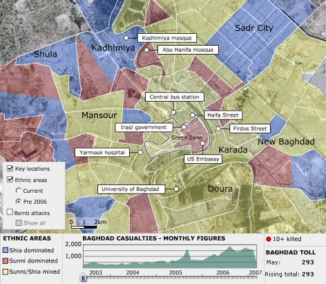
Notice the large beige swatches of ethnically mixed Sunni/Shia neighborhoods that predominate the center city.
Now look at what has happened to those neighborhoods in just one year.

As you can see, much of Baghdad has gone from mixed to single ethnicity neighborhoods, with the Sunni-only areas gaining ground mostly on the west side of the Tigris River and the Shia likewise consolidating territory on the east side.
There are a few exceptions to this east-west trend, however. The most important being the red patch in the north of the city around the Abu Hanifa mosque east of the river. This red patch is important because the Army wants to build its wall on the east side of this Sunni enclave. The strategy appears to be to keep the Shia from consolidating all of east Baghdad by setting up a walled firebreak in the 'new' all-Sunni neighborhood carved out this past year.
Still, walls within cities (as opposed to around them) historically portend bad things for non-combatants trapped inside (see Warsaw circa 1943), and given the US track record in places like Fallujah, it is far from certain whether the US is indeed interested in protecting the Sunnis from the Shia (as it claims), or whether it means to corral them in hope of stomping out further resistance.
Perhaps even more worrying than the proposed wall, is the mysterious demolition on Thursday of the famous Sarafiya Bridge, that once connected the Sunni enclave with west Baghdad.
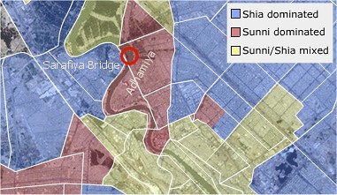
The destruction of the important bridge means that if the Sunni enclave is overrun by the Shia, or if the US decides to attack the enclave, the civilians remaining have lost a major escape route. Blowing the bridge also means that the Shia districts west of the river are similarly cut off from their brethren on the east side, and are now vulnerable themselves to ethnic cleansing by Sunnis.
Some see in the bridge's destruction a plot by Sunni militants to isolate the Shi'a of Kadhimiya and other western Baghdad (al-Karkh) areas. Others see a conspiracy to divide the Sunni population on both sides of the Tigris. As IraqSlogger's Zeyad reported, Mahmoud al-Mashhadani, speaker of the Parliament, accused security forces of destroying the bridge in the process of implementing a divide-and-rule plan to separate Baghdad's communities along sectarian lines.
Whoever blew up the bridge for whatever purpose, it now seems certain that the once ethnically mixed city of Baghdad is irrevocably headed toward permanent ethnic division within respective zones east and west of the Tigris, while the US occupies a bridgehead, for now, in one of the last remaining Sunni areas east of the river.
Yet, how long the US can even hold this enclave remains an open question. The BBC tool also has a slide feature for mapping attacks by time over the course of the occupation. Click the checkbox labeled ‘bomb attacks’ and slide the counter across from 2003 to 2007 and to see just how quickly the number of attacks all over Baghdad has exploded – especially in the last year.
Surge or no, the rapidly declining ability of US forces to control the mushrooming violence in Baghdad does not bode well for US troops. Indeed, the way things are going, the wall they build for the Sunnis today may very well be the same wall they hide behind tomorrow.
Also posted at Hoot at the Dark.
H/T Bernard at M of A for the tool link and bridge map.
