This is not a campaign diary; I include the CA-42 listing simply because what I have to report does involve the district and because I know that people looking for information about Ron Shepston ("CanYouBeAngryAndStillDream") may look for it using that tag. I have posted in the Liveblog thread, but again I know that some people have been watching for my diaries on Ron so I am posting separately. The etiquette of a situation like this is very unclear so I ask for indulgence.
I want to reiterate my liveblog post here, to which I can add that I just spoke to Ron's wife Belinda, who saw Ron yesterday for the first time since Monday. He is, as thought, working with the firefighting team in Silverado Canyon; the only thing Belinda knew specifically is that he has been clearing brush. (Obligatory Bush's "ranch" reference omitted.) But the danger to the 750 homes in the community may come as much or more from trees.
(more)
Update: good LAT story here.
First, my previous post follows (with a little editing.) Again, sorry about any etiquette considerations, but our friends in the area are not likely to look through the liveblog posts for updates.
It occurs to me that since I'm not in the liveblog I can post the relevant portion of the LA Times map. My fair use justification is available for LA Times lawyers upon request.
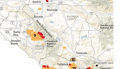
First, if you want a good map of the fires, look here. I'm talking in this post about #9, pretty much in the middle of the map.
My understanding is that Silverado Canyon, where Ron lives and which I've described previously, has not yet been broached by fire. But as you look at that map, you'll see something chilling. The fire, which had been burning south, is now burning east. I don't know if that little gap you see just northwest of the "9" is Silverado Canyon, but it looks to be in the right place.
According to this LA Times story, the concern now is over fire backing into the canyon -- that is, starting at the top in Cleveland National Forest and then flowing downhill. This is bad news on two fronts: Ron's house is at the top of the canyon, and his escape route for a fire coming up canyon was through the forest. (I assume that he could now escape down canyon if need be.) I assume that there is fuel left in the part of the forest just above the canyon, or the fire would probably already have come down.
Less parochially, if you look at that hilly area running diagonally parallel and to the east of the burn area, that's all wood (Cleveland National Forest) and dry vegetation as you move north. When you see people worrying about the jump to Riverside, you can see how close the county line is. People have been worrying about imminent threats to Corona; I don't see it as imminent -- it must be 20-30 miles away -- but once the fire starts heading in that direction it will take a monumental effort to stop it. My recollection is that the path to the other large population center, Temecula, is not so heavily wooded, though would have dry vegetation. In between the two (and not on the map) is Lake Elsinore, which seems to be the most directly threatened.
My guess is that this fire will be a big story over the weekend, unfortunately. Many miles away (near where the 57 and 91 meet on that map), I'm still smelling smoke.
Cleveland National Forest is huge, and reporting on what aspects of it have already burned is spotty. Once you get past the canyon communities, it's depopulated and has limited landmarks. It's possible that there has been a firebreak already burned out between the top of Silverado Canyon and portions that are burning to the east, but I've seen no reporting, and if there is then that would just be dumb luck. But as we can see from photos of housing developments with patchword fires, luck happens.
The larger story, and the larger fire, would be the spread of the fire towards the as yet almost entirely untouched Corono to Temecula corridor off of I-15. (This is in Ken Calvert's and Darrel Issa's districts respectively, if you are curious.) A conflagration in the Cleveland National Forest could affect a wide swath of western Riverside County and would take immense resources to contain. You can see the size of the forest on the map. From the looks of things, this could end up being the size of the Witch fire if things go badly.
I plan to be in touch with Belinda and will post updates and new diaries as appropriate.
