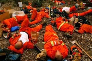
The firemen were surprised that the evening winds failed to materialize as predicted. The most threatened firefighters--those on foot using hand tools to create fire breaks--were able to stay on the job, unlike yesterday when they were in full retreat for a few horrendous hours.
After a day of hot, dangerous work, they are being asked to work 24-hour shifts now. The winds have been swirling today, but generally pushing the fire up the mountains away from population centers. This is not complete victory, however, because if the fire tops the mountain and moves to the opposite side, it could spread in both directions and, dependent on the wind, come speeding back over the mountain as two separate fires.
While that scenario is one concern, what has actually happened is that winds suddenly pushed the fire west toward Goleta starting at about 8 p.m. The evacuation area has been expanded all the way to Route 154, including the Painted Cave area.
From Matt Kettmann and Chris Meagher in the Independent:
Just after official word came out that 75 residences have been burned by the Jesusita Fire, it seems that many more are in the danger zone. The fire is moving fast to the west, causing more mandatory evacuations (including Painted Cave and East Camino Cielo homes), and unconfirmed reports say that it has jumped Highway 154. Meanwhile, a mix of evacuees, stay-and-fight homeowners, looky-loos, and the media is causing traffic jams along Foothill Road and Cathedral Oaks, potentially exacerbating an already dangerous situation by blocking exit routes.
[snip]
All these resources will be thrown against a fire described by one Forest Service commander as a "three-headed monster," raging simultaneously to the east, the west, and the south. The fire’s size was estimated to be 1,300 acres as of early Thursday morning, May 7—with zero containment.
Residents, the traffic sounds tough. If you are in an evacuation zone, get out now.
The Santa Barbara County Sheriffs Department has issued a Mandatory Evacuation Order for all residents north of Highway 192 (Foothill Road) east of Highway 154 to Ontare Road and Morada Lane. This is in addition to previous mandatory evacuation orders.
Painted Cave area Mandatory Evac
Added to the 8:17pm order -- north of HWY 192 (Foothill) east of HWY 154 to Ontare and Morada Lane

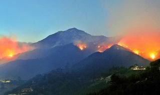
Please view this dramatic photo in its original size. More firefighters have been hurt. Be smart firefighters. These are just buildings.
Nick Welsh reports:
Kelley Gouett, eassistant incident commander, warned firefighters and their commanders to take extra care with regard to their personal safety. Gouette noted that yesterday’s flame columns jumped 100 feet high. "This fire is behaving like it’s an October fire," he said. "It is okay to back out and let structure zones go if it is not safe."
The Independent
KCSB webcast
Incredible LA Times photos, updated often
The fire has moved considerably west since this photo was taken.
Preparing for 24 hours of hot, dangerous, backbreaking labor. Hug a fireman. And NO MORE INJURIES. Get the hell out and we'll all rake the ashes up together another day.
Just reading, the evacuation area is huge, extending from Montecito all the way out to 154. It seems there may be two fronts to this fire now, but I haven't read that anywhere. Winds have picked up in Montecito.
The others under mandatory evacuation orders include San Roque south to Calle Noguera, Calle Noguera to Alamar Road, Alamar south to State Street, State Street to Constance, Constance to Garden, Garden to Micheltorena, Micheltorena north to the end of the road, extending to Alameda Padre Serra, Alameda Padre Serra east to Sycamore Canyon Road on the east, and north on Sycamore Canyon to Highway 192 to El Cielito.
Update I: From the Independent
A mandatory evacuation order is now in effect for all areas north of Cathedral Oaks Drive east of Highway 154 to San Jose Creek (Near Patterson Avenue), all areas north of La Colina Road between Highway 154 and La Cumbre Road, and all areas north of State Street between La Cumbre Road and San Roque Road. An evacuation warning has been issued for the area south of Cathedral Oaks Drive, west of Highway 154, east of Turnpike Road, and north of US Highway 101.
New areas under evacuation: westbound State Street from Constance to La Cumbre, north on La Cumbre to La Colina Road, west to Highway 154, 154 to Highway 192 (Foothill and Cathedral Oaks), west to Patterson, north on Patterson to San Jose creek to Camino Cielo.
Update II: A new Red Cross shelter has been established at UCSB’s Thunderdome. Better known to some perhaps as the events center, this location is now accepting evacuees — and likely will be, as a result of new mandatory the evacuation notices. The existing shelter at Dos Pueblos High School is reportedly full.
Update III: Here's an 11 pm report from KEYT.
They contradict themselves in this one broadcast. The studio reporters say the eastern flank toward Montecito has calmed down considerably but the western side toward 154 and Painted Cave is problematic. The field reporter then says basically the opposite. This fire is completely unpredictable, just as the weather has proven to be.
Update IV: As of 11:45 pm, new area advised to be prepared for evacuation. From the Santa Barbara County website:
An Evacuation Warning/Advisory has been issued for the area north of US Highway 101 from Turnpike Road west to Fairview Avenue (western boundary), Fairview Avenue north from the end of Fairview to West Camino Cielo. This includes residences on West Camino Cielo. Residents are advised to prepare to evacuate.
The evacuation area continues to move west. This new area under warning is now most of Goleta north of 101 all the way up to the ridge.
