I've got about ten minutes to write this diary, so I'm just doing to dump as much stuff in here as I can, and hopefully get back to it later today if it needs some fleshing out.
On Sunday, I was going back and forth with Dr. Ben Marble (he of the "Fuck you, Mr. Cheney" post-Katrina fame). Ben is nothing if not a social activist, and he lives near the belly of the oily beast that BP has created.
One of the things that struck me during our conversation was when he said, "they won't let us go out there...it is pure crap...can't go by boat or air". And I'm like, "What? It's open ocean. It's open air space." And then I started doing some digging...
Sure enough. On May 7th, at 19:51UTC (2:51PM, EST) the FAA issued a Notice to Airmen (NOTAM) titled GULF OF MEXICO OIL SPILL AND AFFECTED COASTLINE, United States. Basically, what a NOTAM does is set up flight rules and restrictions in a specific area of U.S. airspace - say, in the airspace over a secret military installation.
NOTAM 0/9264 establishes restricted airspace over essentially the entire U.S. Gulf Coast. (Take a look at the full size map, here.)
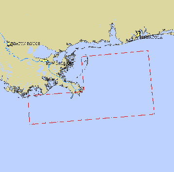
What the text of the NOTAM says, though, is probably more important than the map itself. As Jim214 noted in a throwaway comment I made about this NOTAM last Sunday:
If you look at it, it appears to cover only private aircraft, like your neighbor's Cessna 172 or Piper Cherokee, and of course news media helicopters or owned or chartered aircraft without a "need" to be in the proscribed area. It would also cover any data-gathering flights by oh, state environmental agencies and maybe non-beholden scientists trying to estimate the conditions and impacts. Don't know which video and what date you mention, but the NOTAM was put out on May 7, effective immediately.
All aircraft operations are prohibited except those flights authorized by ATC, routine flights supporting offshore oil operations; federal, state, local and military flight operations supporting oil spill recovery and reconstitution efforts; and air medical and law enforcement operations.
Otherwise, BP's fucking executives just have to squawk a code on their transponders and call Houston Control and stick to certain assigned altitudes. They can tour at will, along with government and other "response" flights. And of course the scapegoat Coast Guard, being tasked on a shrinking budget to take on yet more thankless and fruitless work, and any jet jocks from Pensacola tightening up their skills to fight the Chinese at the Gates, or whoever our next bullshit "enemy" is determined to be.
Ok, here's what's really interesting. Note again that the date on the NOTAM is 5/7, and it was issued late in the day. Is it pure coincidence that this NOTAM was issued the SAME DAY that this scathing video (from a previous diary) was taken, on a fly-over earlier in the day on 5/7?
I'm much too jaded to believe in coincidences. The NOTAM was issued right after this video hit YouTube.
I'm also guessing (but don't have the time to research) that there's some similar restriction on watercraft and boat operations in the area.
Certainly, the government would prefer that not ever little skiff boat in the U.S. be putt-putting around the Gulf of Mexico right now, but really, a total restriction on visualization of the scope of the disaster?
I'll be back later to flesh out this diary and thoughts, if it's necessary. My 10 minutes is up...

