"The saddest thing was the crying of the horses", my 82 year old Sanford neighbor told me about the damage you didn't hear on the news about the North Carolina tornadoes. The horse farm between Sanford and Fuquay Varina on NC42 was leveled. I had stopped on NC42 for the road clean up by workers with chain saws and bulldozers but I didn't see the missing house and barn.
It's hard to see something that's gone.
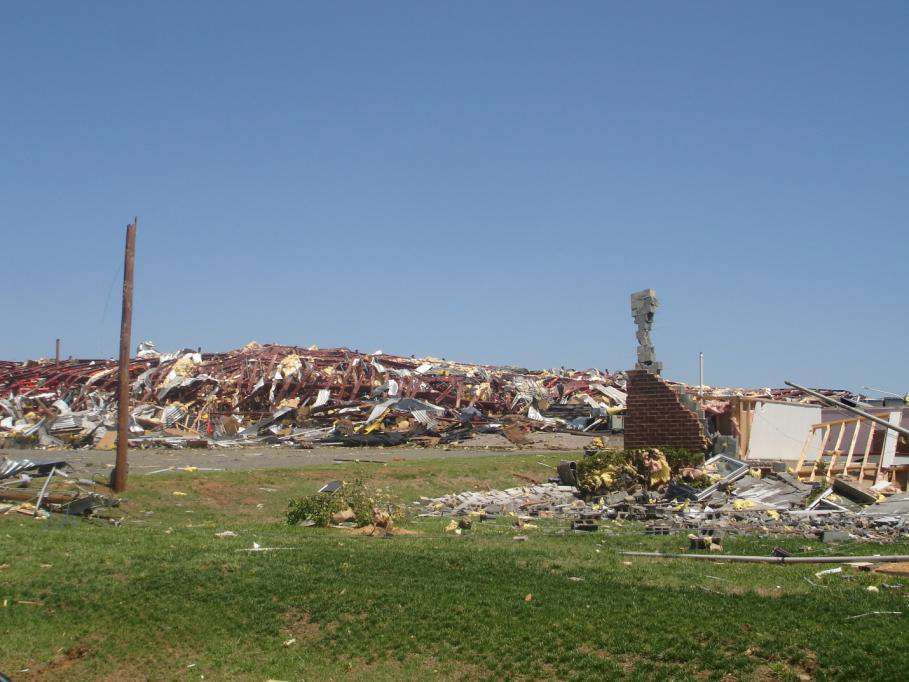 Lee Ave., Sanford NC, Static Control Corp. warehouse hit by 160mph plus winds.
photo: Raleigh NWS
THE TORNADO THEN ENTERED AN INDUSTRIAL COMPLEX ALONG INDUSTRIAL DR WHERE IT MULTIPLE STEEL CONSTRUCTED RETAIL BUILDINGS WERE DESTROYED IN ADDITION TO AT LEAST THREE LARGE WAREHOUSES AT THE STATIC CONTROL FACILITY. WINDS IN THIS AREA LIKELY EXCEEDED 160 MPH. THE TORNADO THEN DESTROYED THE TRACTOR SUPPLY COMPANY... BIG LOTS... AND LOWES HOME IMPROVEMENT STORE ALONG HIGHWAY 421. WINDS IN THIS AREA WERE ESTIMATED AROUND 140 MPH. TWO HOMES WERE BLOWN OFF THEIR FOUNDATIONS ALONG RICE RD NORTH OF HIGHWAY 42. A FATALITY OCCURRED ALONG POPLAR SPRING CHURCH ROAD IN A MOBILE HOME.
Somehow the homeowners survived by hiding in the safest spot in the house, but the barn was destroyed and the horses were picked up by the tornado and scattered. The owners of the farm could hear the horses crying but they couldn't find them as afternoon turned to night.
The official reports on severe weather and climate change never mention the suffering of the animals. They don't tell about the horses with broken legs wailing in pain in the night after an unprecedented tornado outbreak. They say:
A FATALITY OCCURRED ALONG POPLAR SPRING CHURCH ROAD IN A MOBILE HOME.
It could have been someone I canvassed when I campaigned for President Obama. I don't know.
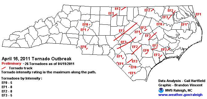
The National Weather reports that North Carolina was hit by 26 tornadoes.
In her 82 years, my neighbor told me she has never seen weather like this. She said that the next day (the day I was talking to her) the veterinarian was finally able to get to the horse farm, the horses were found, and put out of their misery.
Dr. Jeff Masters, severe storm expert, reports this year likely has the highest number of tornadoes ever reported by April 20.
The storm responsible will trek eastwards today, bringing the threat of severe weather to regions of the Southeast hard-hit by last week's remarkable tornado outbreak. NOAA's Storm Prediction Center has placed a wide swath of the country from Eastern Texas to New Jersey under their "slight risk" for severe weather. According to the latest tornado tallies on the excellent Wikipedia page on the April 14 - 16 tornado outbreak, 128 tornadoes are confirmed to have occurred, with 39 of these strong EF-2 and EF-3 twisters. Remarkably, there have been no violent EF-4 or EF-5 tornadoes reported yet in 2011, despite the fact that the preliminary 2011 tornado count as compiled by SPC is 611, which will likely make 2011 the most active tornado season on record for this point in the year.
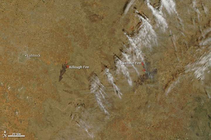
Texas, hit by dust-bowl-extreme drought, is on fire. Here, Black Mountain is burning.

The Hobby-Eberly Telescope dome is at right. Above it, the bright line on the right is the wildfire which broke through a burn-out line on Sunday afternoon. The bright line on the left is the front of a back-fire set to stop that portion of the wildfire. Silhouetted by the back-fires on Black and Spring (to the left) Mountains is Guide Peak now with only small pockets of active fires. (Credit: Frank Cianciolo/McDonald Observatory)
Most of Texas never got winter rains. La Nina weather patterns, very likely enhanced by climate change, took the winter storm track north of Texas, leaving much of Texas dry since November, 2010. Most of northern Mexico is also in extreme drought because winter rains went north.

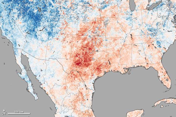
Temperatures in Texas were as much as 20 degrees F above normal according to NASA, contributing to the extreme fire hazard.

So far in 2011, more than 1.4 million acres have burned in Texas. Some 800 fires have occurred throughout the state, burning 401 structures and costing two firefighters their lives. Why is fire activity so extreme in Texas this year? This image, made with data collected by the Moderate Resolution Imaging Spectroradiometer (MODIS) on NASA’s Terra satellite, reveals high temperatures that contributed to hazardous fire conditions.
Fire needs dry fuel to burn, and weather conditions in March and April turned Texas into a tinderbox.The state began the winter dry season with abundant vegetation, following a moist spring in 2010. But then drought settled over the state in late 2010 and early 2011, culminating in the driest March on record. Many areas received less than 5 percent of their normal rainfall, according to the state climatologist.
In addition to being dry, March and April were warmer than normal. The top image shows ground temperatures for April 7 to April 14 compared to long-term average for the week. The red tones indicate that most of Texas was much warmer than average, further drying out the abundant grasses, shrubs, and trees already suffering from a lack of rain.
Central Texas fires April 10, 2011
"This is a situation of historic proportions," said Victoria Koenig, public information officer with the Texas Forest Service, in a phone interview with AccuWeather.com Tuesday. "The fuels are so dry. The winds are astronomical. The behavior of the winds is a perplexing situation. It's never been like this before."
Koenig added, "When you put all the ingredients together, you're getting close to having the 'perfect fire storm'."...
Dan Byrd, meteorologist with the National Weather Service in Jackson, Miss., said, "This is an unprecedented drought situation [in terms of] how widespread it is and the depth of the drought. We haven't seen anything like this for the state overall since the early 1900s."
What ties the fires, drought and record tornado activity together? The warm Atlantic/Cold Pacific sea surface temperature pattern, likely responsible for the dust bowl weather, is being repeated. La Nina, enhanced by global warming, which has contributed to record warmth in the north Atlantic in recent years, is likely a major contributing cause. Moreover, dry air between ten and twenty thousand feet enhances downdrafts that lead to tornado formation. The air above 10,000 feet was bone dry, while exceptionally humid air off of the much above normal (warm) Gulf Stream blew in from the south ahead of the violent weather. North Carolina had atmospheric conditions usually seen only in tornado alley.
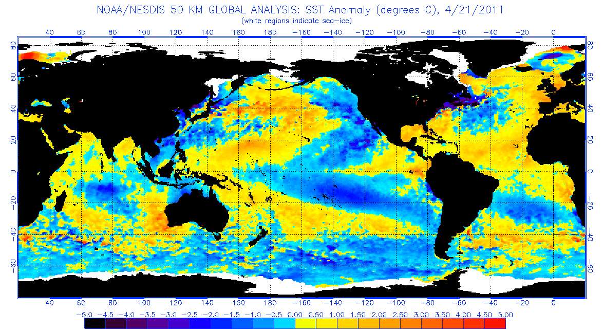 Image source: NOAA.
