"In years to come when I am asleep beneath the pines, thousands of families will find rest and hope in this park." -- Enos Mills
In the years before 1915, when President Woodrow Wilson proclaimed Rocky Mountain National Park our nation's tenth park, the area had already been witness to several changes in human history. The area of the park, sometimes called RMNP by locals, had been occupied by Native tribes as far back as the Clovis culture around 10,000BC. The ancestors of the modern Ute, Apache, and Arapaho tribes all roamed the mountain passes of the region, hunting the abundant Elk population that remains a signature of the park today. As European settlers moved in to the area in search of gold and homesteading, they found something of greater value - the waters of the Colorado River, which they diverted in part back to the plains cities developing on Colorado's eastern Plains, setting up a struggle for control of water that also continues to this day.
And so it was that in 1909 Enos Mills, now legendary local guide and naturalist, began a tireless campaign to lobby for the creation of Rocky Mountain National Park, to protect it from the seemingly inevitable development that was encroaching on the area.
Now a World Biosphere Reserve, the park showcases the changing face of our parks while serving as a natural laboratory for biodiversity due to its range of climate zones.
The Changing Face Of The Parks
Enos Mills is most credited with lobbying for Federal protection of the park lands, though as with most national parks, Rocky's supporters were numerous and organized - a show of lobbying at its best. Mills ran a lodge in the area from which he led visitors on guided tours throughout the park at all levels of difficulty. He wasn't alone: in the park's early days there were many private inholdings within the park boundaries. Although a few of the inholdings were private homes, many were - or grew into - lodges, resorts, and other public accommodations. In the park's early days the inholdings even included a swimming pool and golf course! This wasn't uncommon in the early days of the park system, in fact; in the beginning the park system's resources were very limited, and private landowners often did much of the work on developing the park for tourism.
The early inholders at RMNP did just that, building roads and trails for their customers to enjoy. But the pace of development, even with the help of the park's early Superintendents, could not keep up with visitation. The Great Depression brought on another wave of development in the form of the Civilian Conservation Corp (the CCC), who developed trails and park facilities; at the same time, the Park Service and the Bureau of Roads (now the FHA) constructed what is now the park's main attraction - Trail Ridge Road, the nation's highest through highway.
But commercial exploitation of the park wasn't done. In the 1950's, a ski area was permitted to open within the park boundaries. Hidden Valley operated with the support of local businesses as a small downhill ski area until 1991, when the park shut down the remaining lifts on the mountain and began reforesting the slopes.
By the 1960's, the Federal government realized that its national parks were all woefully underdeveloped for the visitation they were receiving (and likely to receive in the future). Mission 66, as the project was called, brought massive improvements to the facilities of parks across the nation, and Rocky Mountain was no exception. The park's visitor centers and many of its current facilities all date from this period of intense park development.
After this period of development, environmental concerns took hold in the park service, and in the 1990's under Bill Clinton, much of the park was designated as a Wilderness area, granting it extra protections above and beyond its designation as a park. Park management has also tried to contribute to environmental protection within the park by creating a shuttle system that serves the hiking areas of Moraine Park and Bear Lake / Glacier Gorge. Bus access is normally via the Park & Ride within the park itself, but the park also operates a "hiker shuttle" that connects to the town of Estes Park (and from there, visitors can use the Estes Park town shuttle system to get around without hopping in a car...).
The march of time has also altered environmental conservation methods in the region. The last Wolf was extirpated from the area around 1920, ten years after the park opened, and the result was an explosion of the already abundant Elk population when Elk were re-introduced to the area (they had also been extirpated - thanks to ban nock for correcting me on this...). This in turn altered the health of Aspen, Willow, and other plants that the Elk increasingly munched on; the park's Aspen now consist mostly of mature stands and stunted Elk-eaten younger growth. Initial talk of re-introducing the Wolf, which was so successful (and now under such attack) in Yellowstone, has been halted by a combination of rancher opposition and a study that supposedly says the park and surrounding areas could not sustain a Wolf population. Park snipers, birth control, and fencing around sensitive plant areas are now being implemented to control the Elk and restore health to the Willows and Aspen decimated by too many complacent Elk.
At the same time, the Federal government began ruthless fire suppression efforts on most all of its lands, thinking to increase the value of the land (and save lives in populated but forested areas). The ecology of the Rocky Mountain forests, especially in regards to Lodgepole Pine and other species that rely on fire both to control their growth and spur new sprouts, was not well understood in those days, and as a consequence the forests grew in an unhealthy (though lush-looking) way. Late in the last century the government began to see the error of its ways and started a program of manual thinning, controlled burns, and in some cases allowing natural fires to burn to restore the health of the forests. But it appears they were too late, and Mother Nature has now stepped in with her own thinning process - the Pine Beetle, helped along by global warming. In the past 5 years, the Pine Beetle has decimated the forests, especially in the western section of the park where Lodgepoles make up perhaps ninety percent of the forest; one of my favorite campgrounds at the park, the formerly forested Timber Creek Campground, is now almost completely devoid of trees.
A Biosphere Reserve
Rocky Mountain National Park encompasses an incredible range of natural habitat at elevations starting at 8,000 feet through more than 14,000 feet, covering the Montane, Subalpine, and Alpine zones. The rugged terrain limits human intrusion, allowing the local wildlife to thrive relatively undisturbed. Of course, that's if the wildlife wants to be undisturbed: the local Chipmunk, Ground Squirrel, and Jay populations are notorious beggars in the park's picnic and campground areas, as well as at some of its roadside pull-offs.
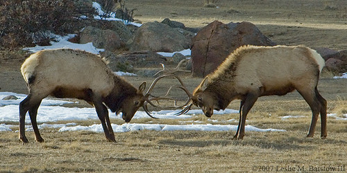
Sparring Elk
The park is home to some 3,000 Elk, making Elk watching one of the most popular reasons for visiting. The Elk migrate vertically within the park, both seasonally and daily. On a summer day they can be found up on the high tundra along Trail Ridge Road, snacking on the rich grasses and flowers that sprout during the short growing season. At night they migrate down the mountains to the lower meadows within and around the park, escaping the overnight chill. During the winter, Elk usually stay among the lower trees and meadows within the park, as well as outside the park boundaries. It is very common to see Elk in the gateway town of Estes Park in the winter months, especially on the golf course and in any grassy area available. Bighorn Sheep and Moose (supposedly re-introduced in 1972, though the population grew so fast that many suspect a native population already existed...) are also commonly sighted within the park; you can usually tell there's a Moose sighting on the west side of the park by the Yellowstone-style traffic backups.
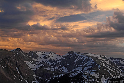
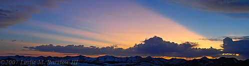
Stormy Sunset along Trail Ridge Road
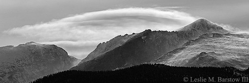
Trail Ridge Road, mentioned above, allows visitors to see the entire range of the park's diverse terrain and ecology, taking them from the Montane meadows and wetlands around Beaver Meadows through the dense pine forests as they switch from Ponderosa to Lodgepole to Limber Pine, and then up into the treeless alpine tundra above about 11,000 feet. Once within the tundra, visitors can walk several trails to view the abundant alpine flowers and perhaps catch a glimpse of a Marmot or the industrious little Pica; a visitor center, cafe, and gift shop also give visitors a chance to relax above treeline. The west side of the road leads down over the Continental Divide and in to the Cache la Poudre and Colorado River headwaters regions of the park, where miles and miles of trails lead among the lush meadows and forests along the rivers. The old Fall River Road, which predates Trail Ridge, is an alternate possibility during the high summer months, for those who want a more rugged trip up to the alpine visitor center; it has more forests and some nice falls and cascades, but it's a one-way dirt road that usually has some deep ruts; cars are usually okay on it if careful.
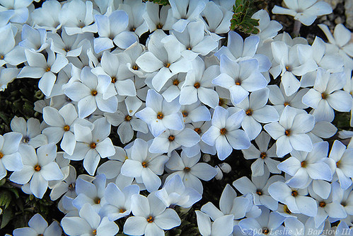
Alpine Phlox
The park's main hiking area is not the high country along Trail Ridge, or even the western river basins, but rather the Moraine Park, Glacier Gorge, Bear Lake, and Fern Lake area, serviced during the summer months by the park shuttle I mentioned earlier. Many of the trails in this area interconnect; a really ambitious hiker could start down at the shuttle lot, hike up through the Glacier Gorge area to Bear Lake, hike up over the top of the world and down to the Fern Lake trailhead (and probably back to the shuttle lot again). Along the way they'd be treated to roaring streams, a number of waterfalls, countless small glacial lakes and alpine tarns, soaring mountains, and the sheer beauty of the forests and meadows. The water and the mountains are the main attractions in this area of the park. Most if not all of the trails target a mountain or water destination.
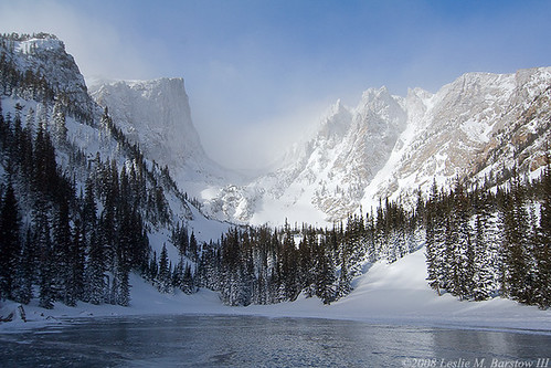
Dream Lake
Also accessible from the Glacier Gorge area, though most frequently accessed from a separate park entrance, is the 14,259 foot summit of Long's Peak, popular destination for (fit) hikers and experienced rock climbers alike. Long's is the highest mountain in the park, and easily the most unique looking. With its mostly flat top and the sheer 3,000 foot face of "the Diamond", it is recognizable from almost any angle. It is iconic enough to adorn the Colorado quarter, and was a popular hiking destination with Enos Mills and his guided tours. It is also usually the cause of a few deaths every year, mostly from people ascending too late in the day and getting caught by a storm (or lightning). (Park warning of the week follows...) Be careful, informed, and prepared when entering the high country; wear or carry layers of clothes, up to and including winter clothing, carry extra food and water, trail-finding supplies, and let someone know where you plan on going.
Visitors who want to see the quieter parts of the park should consider the western side (now less pretty due to the pine beetle) or the less visited Wild Basin area, which like the Glacier Gorge area is a region of forests and water - though fewer mountain features.
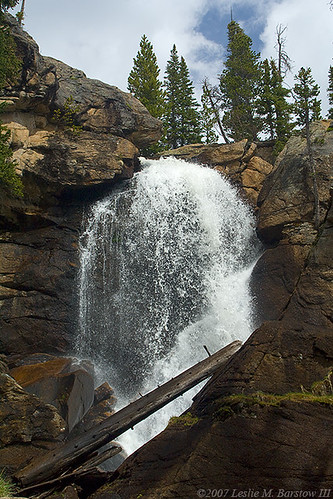
Ouzel Falls, in the Wild Basin area
I hope you have enjoyed this trip through the diverse and still-changing land of Rocky Mountain National Park.
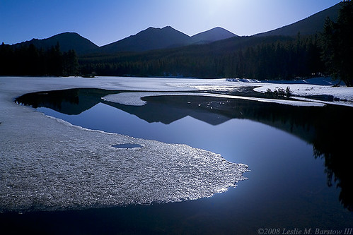
Sprague Lake, Glacier Gorge area
Neversummer Sunset from Trail Ridge Road
This has been yet another entry in the Park Avenue Thursday National Parks diary series. Sorry we've been on break for a couple of weeks, but we should be back to normal - or something resembling it - soon.
Other diaries in this series include:
- Jackson Hole National Monument
- Fort McHenry National Monument & Historic Shrine
- Capitol Reef National Park
- Petrified Forest National Park
- Sequoia & Kings Canyon National Parks
- Dry Tortugas National Park
- Wind Cave National Park & Jewel Cave Natl Monument
- Death Valley National Park
- Zion National Park
- Saguaro National Park
- Everglades National Park
A more tourist-oriented series runs on Tuesday, our "Things To Know Before You Come..." diaries, chosen by Daily Kos users from our Friday "Photo Friday & Open Thread" diaries. Finally, we also have a Saturday series on our state parks.
You can see all of the Park Avenue diaries on the Park Avenue blog page, where you can also click on the "Follow" link to follow the blog entries on your own page, or get an RSS feed of the blog.
