Most of us by now know the horror that is the 'Fitzwalkerstan', but what has not been talked about since the 2010 elections here in Wisconsin is how the Republican led legislature is now in charge of redistricting. Remember that only 3 years ago, Wisconsin gave Obama a double digit victory here, had a Democratic governor, a Democratic majority in the state senate and narrow deficit in the state house. Fast forward to 2010-11 and we have a Republican governor and Republicans in charge of both the senate and house. Presently the Congressional delegation is split 5-3 Republican, but has been 5-3 Democratic or 4-4 in recent years. What if the Democrats had won again in 2010 and were in charge of the redistricting process? Well, this is my attempt through Dave's Redistricting App to perform the "what if".
Wisconsin still remains with 8 seats and the present makeup has 2 completely safe Democratic seats (the 2nd and 4th) and 1 completely safe Republican seat (5th). All the others are seats that have PVI's of 5 or under (1st - R+2, 3rd - D+4, 6th - R+5, 7th - D+2 and 8th - R+2). The 3rd and 8th have been the most hotly contested races recently and the 7th switched in 2010 mostly due to David Obey retiring and a horrible year for Democrats period. What is surprising is that 1st district hasn't been competitive with only a R+2 PVI. Well, part of it is that the incumbent is the one and only Paul "let's kill Medicare" Ryan.
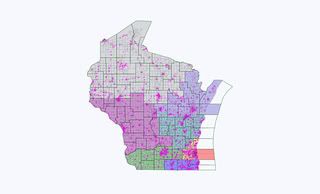
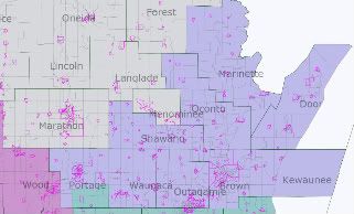
While I wanted to look at the political makeup of each district, I also wanted to make an effort to keep whole counties and cities together whenever possible. The other factor I wanted to take into account was purely personal. I wanted to get my house out of the 5th district.
So, my first act was to see what I could do to make District 1 a more Democratic
district. In 2008, his Congressional district did vote for Obama 51% to 48% although Kerry got 46% and Gore 45% in 2004 and 2000 respectively. My first thought was to move Ryan's hometown of Janesville completely out of the district and make it part of Tammy Baldwin's 2nd district, a 70-30 Democratic district that includes all of Madison thereby forcing Ryan to run in a very Democratic district. But even with that, the 1st district would have been even more Republican and Democrats wouldn't have gained any increase in their state delegation size.
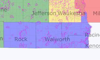
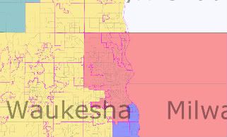
The new 1st district would include all of Rock county instead of just the portion that contains Janesville as it presently is made up. It included all of Walworth, Kenosha and Racine counties. I removed the southern part of Waukesha county and the towns of Franklin, Greendale, Greenfield and Hales Corners in Milwaukee county and instead added the slightly more Democratic Milwaukee suburbs of Oak Creek, South Milwaukee, Cudahy and St. Francis. With this new 1st district, the 2008 Obama vote would go from 51% in its present construct to nearly 56% with this redistricting. This would make it much more of a swing district and one that would slightly favor Democrats.
The 2nd district which right now has a PVI of D+15 would remain solidly Democratic with still a 68 to 30 Obama vote. The other difference in this 2nd district is that I had it go to the west all the way to the Mississippi River instead of north up to the Wisconsin Dells as it is presently. With the exception of a small portion of Columbia county to the north of Madison, all of the district would be made up of the entire counties of Jefferson, Dane, Green, Iowa, Lafayette and Grant.
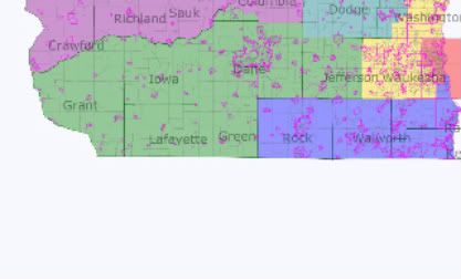
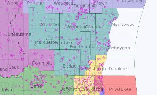
With the 2nd District taking the southernmost counties of the present 3rd District, I decided not to push it further north but actually a little further east to make up what was lost. Most significantly, I added Wood County with Wisconsin Rapids and all of Sauk and most of Columbia counties with Baraboo (home of the Ringling Brothers Circus) and the Wisconsin Dells. Again, with the exception of a small portion of Columbia county given to the 2nd district and most of Dunn county given to the 7th District, all other counties within this district were kept intact. Even with the minor changes, the political makeup remained roughly the same (58 to 40 Obama compared to 58 to 41 in the present configuration).
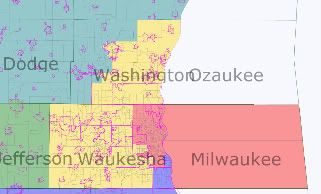
The most Democratic district in the state is the 4th District and under this remap it would continue to be so. This is where the redistricting became personal for me as I am now in the 5th District represented by Jim Sensenbrenner (R - Douchebag)and I needed to redistrict him out of my community. His district is most of the now "infamous" Waukesha County along with Ozaukee and Washington counties, probably the three most Republican counties in Wisconsin and then it goes around the mostly African American northside of Milwaukee to grab the north lakefront suburbs of Milwaukee county. The northern and southern suburbs of Milwaukee county have shifted in the past several decades. The northern suburbs were solidly Republican and the southern ones solidly Democratic. Now it is reversed as this article published a few months ago in the Milwaukee Journal Sentinel notes.
Change in Milwaukee suburbs
My 4th district remains relatively static except that it is more compact now. Presently, the district encompasses all of the city of Milwaukee, the suburbs of West Milwaukee and West Allis just to the west of the city and some of the southern suburbs of Cudahy, St. Francis and South Milwaukee. With this map, it still retains all of the city of Milwaukee but drops the southern suburbs and West Allis to take in all the northern suburbs of Milwaukee County and Wauwatosa to the west. Not only does it put our house in this district but it also has the added joy of having Scott Walker's hometown of Wauwatosa in the most Democratic district in the state.
From the joy of redistricting myself into the 4th District, I swing back to discussing the most Republican district in the state, the 5th District. It is a district that used to be a Milwaukee district before the 2000 census that dropped the state delegation from 9 to 8 seats. Most of the present 5th district was part of the 9th District which hadn't elected a Democrat since the early 60's. In fact, the 9th district elected a Republican even in the landslide election of Lyndon Johnson in 1964. One other tidbit of fact about the 5th district is the Representative just before the 2000 census redistricting was none other than Tom Barrett, mayor of Milwaukee and candidate for governor in 2010.
In my map, the 5th district becomes even more of a Republican vote sink. McCain won this district in 2008 by 58 to 41. With my new 5th district, that margin would increase to 60-39. Whereas the old 5th gave a portion of southern Waukesha county to Paul Ryan's 1st district to make it more Republican, I am letting Sensenbrenner have all of Waukesha county. The small portion of Jefferson county is removed from his district and a good portion of Washington county is also taken away. In it's place, he takes more of Ryan's district in Milwaukee county by taking most of the western and southwestern suburbs of Milwaukee.
While the 6th district did vote narrowly for Obama in 2008 50% to 49%, it is a district that has not been held by a Democrat for more than one election cycle since the Great Depression. In an open seat election in a Democratic wave election this could swing to the Democrats, but I wasn't able to alter the political makeup too much without affecting other districts significantly. It switches to a 50 to 49 McCain district with this map. The biggest change was adding some portions of Washington county and taking away all of Adams county at the far western edge of the district. It still retains the cities of Fond Du Lac, Oshkosh, Neenah, Manitowoc and Sheboygan however. It is probably the district whose boundaries changed the least. Besides the portions of Washington and Portage counties, the rest of the district contains the entire counties of Dodge, Fond du Lac, Manitowoc, Sheboygan, Calumet, Green Lake, Winnebago, Waushara and Marquette.
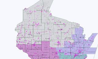
The 7th district, by far the largest of Wisconsin's congressional districts would become even larger in my map. Although represented by Democrat David Obey for more than 40 years, the district only slightly leans that way. Kerry got 51% of the vote here and even though Obama won handily here, it mirrored the statewide margin for him. In 2010, when Obey retired, the Republican, Sean "the Real World" Duffy, won this seat.
In my map, the 7th district grows further to the east and becomes slightly more Republican by a point or two. It's still very much a swing district and if Democrats are doing well overall, they probably are able to win this seat. The only way to make this a more friendly district for Democrats would have been to weaken the 3rd district which already has a Democrat, Ron Kind, who barely survived in 2010.
The final district, the 8th, is centered in northeastern Wisconsin and includes the cities of Appleton and Green Bay. I won't mention what Green Bay is known for as I'm a transplanted Chicagoan. This district also includes the resort communities of Door County. Presently, this district has a PVI of R+4 but performs slightly better for Democrats in this remap. Unlike the 6th district, however, which in the best of years for Democrats would be 50/50, the 8th in this map would have given Obama nearly a 10 point victory. Of course, that is a few points below his statewide margin, but this is by no means an unwinnable district for a good Democrat.
Yet again, this district keeps whole counties and communities together. With the exception of a small portion of Portage county in the 6th District, entire counties make up this district.
So, with this redistricting what would the Democratic/Republican congressional delegation look like? Well, let's start with the easiest districts to determine. The two solid Democratic districts (2nd and 4th) and the one solid Republican district (5th) would remain. Next, which districts would lean Democratic or Republican and which would be total tossups? First, the 6th district would have to be a pretty strong lean to the Republican candidate. Could it go to the Democrats? Sure, in the right national situation and as an open seat perhaps, but it's not one that would go on a first nor probably second tier of pickup opportunities. Pretty much the same could be said for the 3rd district except in the Democrats favor. The voting makeup in this map for the 3rd district is about the same as 2008 with maybe a point more towards a Democrat now. And let's face it, if Ron Kind could still win this in the most god awful year for Democratic congressional candidates in a state that turned hard for Republicans in 2010, then you'd have to say this is a lean to probable Democratic seat. This leaves us the 1st, 7th and 8th. First, let's look at the 8th. With all things being equal, this is a district that probably slightly favors a Republican, but it has also elected a Democrat to 2 terms in the past decade. It is a true swing district and would remain so even with this remap. The 7th district when David Obey was in there was a given Democratic seat, but it was never a district like the Milwaukee and Madison districts that could have elected a no name dogcatcher as long as it had a D next to their name. In most years, however, this is still a district that should favor a Democrat slightly even with this map that may give it a little more of the purplish tinge to it. Finally, let's look at the 1st district. In this map this is a much bluer district. As long as Paul Ryan is running, even this map may let him squeak out a victory, but I believe he would eventually move on to some sort of higher elective or appointed office. And we must look at this map for the long haul, the next decade, and this district should be a Democratic one based on previous voting patterns. Based on these assumptions we can probably safely say that in a basic year where neither party has the upper hand, it's a 4-4 split. In a decent year for Democrats, it's probably 5-3 Dems and maybe 6-2. If somehow we had a Lyndon Johnson 1964 type year, it could get to 7-1.
