A large derecho (thunderstorms that form into a bow-shape on radar and produce massive amounts of straight-line wind damage) is moving southeast through Missouri right now, towards northern St. Louis and points southeast of there through Illinois, and possibly into Indiana and Kentucky if it's able to hold together. I try not to use borderline hyperbolic language while talking about weather around here, but I'll be blunt: this storm has a long list of shit it wants to fuck up, so you need to take this as seriously as a 100 mile wide tornado.
This isn't going to be a traditional liveblog in the "Warning for so and so until blah blah," this is impacting a very wide area and moving very quickly. The updates will appear at the top of the body of the diary (below the squiggle), with the newest appearing first.
Let me take this opportunity to remind you that this is exactly why you need a weather radio. It's 200 AM and there's a 130 mile long squall line with 80+ MPH winds ripping through numerous states. That's not the sort of thing one needs to sleep through.
(As usual, keep politics, meta, pie fights and general dickishness out of here or you'll be banished to clip ugly toenails for eternity.)
Updates
Update 8 1155 AM CDT
Good morning everyone. Looks like the derecho wasn't as bad as it could have been -- the strongest ones can go from Kansas to the Atlantic, as has happened before. Here are the severe weather reports from yesterday morning until really early this morning. You can see the line of damage that tore through Nebraska, Iowa, Missouri and Illinois from this storm.

I can't find too much major damage from the storm. There is some home damage, definitely mobile home damage, but from what I can tell there wasn't anything too serious. If you find anything, post it in the comments.
I've also updated the title to reflect that this happened last night, so that people don't think another one is coming. There isn't, right now at least.
Update 7 238 AM CDT
Last of my updates for the night (see update below), but here is the latest radar image from 232AM CDT. Brace yourself, Illinois. The derecho is moving east at between 60 and 70 MPH, and it's producing winds just as strong (and even stronger...80+ MPH winds still not out of the question).

Update 6 225 AM CDT
I hate to do this, but I have to go to bed. I'm about to pass out over here. Here are some links to help you through this storm if you're in the path (or just want to track it).
IEMBOT from Iowa State -- Tracks real-time warnings, watches, and storm reports coming in from the local NWS. Go to the dropdown on the left and find:
[lsxchat] for St. Louis area NWS releases
[ilxchat] for Lincoln IL (central Illinois) NWS releases
[indchat] for Indianapolis IN NWS releases
[lotchat] for Chicago IL area NWS releases
Here are some NWS offices, and their radar (linked separately):
NWS St. Louis -- Radar
NWS Lincoln IL -- Radar
NWS Indianapolis IN -- Radar
NWS Chicago -- Radar
Here's a link to wunderground's radar page, if you prefer that.
Storm Prediction Center
Storm Prediction Center Outlooks
Storm Prediction Center Watches
Storm Prediction Center Reports
Update 5 211 AM CDT
The derecho has made an easterly turn, which will take it across the width of the State of Illinois. Expect it to hit Springfield by 300-330AM Central, then continue east (or even northeast) into eastern Illinois and Indiana later in the morning. Folks in Springfield, Bloomington, Urbana, Peoria, and everywhere in between needs to be on guard.
Update 4 205 AM CDT
This report just came in 5 minutes ago from the NWS:
LSX: Lewistown [Lewis Co, MO] emergency mngr reports TSTM WND DMG at 12:55 AM CDT -- damage reported all across lewis county...large trees down...power lines down...mobile homes blown off foundations.
Update 3 151AM CDT
Quincy, IL airport reports a 75 MPH wind gust with sustained winds (avg. wind speeds over 2 minutes) of 50 MPH.
Here's a "high def" St. Louis radar image from 1:47AM CDT. It's 1.12MB, so I won't make them this large all the time -- did this to show detail for you to get an idea of where this is in relation to towns and cities. Click to enlarge in a new window.

Update 2 144AM CDT
Numerous reports of winds between 60 and 80 MPH coming in from this derecho. Tons of trees and power lines down. From spotters and official stations:
(E = Estimated)
Hannibal MO -- E60 MPH
Loraine IL -- E70 MPH
Canton MO -- 62 MPH
Quincy IL -- E70 MPH
Columbia MO -- 59 MPH
Payson IL -- 80 MPH
New Hartford MO -- 80 MPH
Hannibal MO -- 61 MPH
Update 1 137AM CDT
Tornado warning for a bunch of counties in Missouri and Illinois. Kinks forming in the line next to the strongest winds in the derecho. Areas east of Hannibal and New London, MO on the Illinois side of the Mississippi River need to be prepared for straight-line winds over 80 MPH and rain wrapped tornadoes. I've circled the rotation on this map.

Initial Post
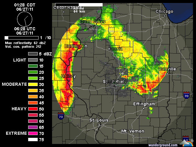
Here's the initial radar at the time of this diary's posting (2:27AM EDT as I type this sentence). The derecho is moving in the direction it's bowing, towards the southeast. It will slam St. Louis within the next 30-45 minutes, and continue on towards the southeast.

Here are the wind velocities I always post during tornadoes to show the wind in the storms. The wind in this derecho has spiked off this level of radar's capability to detect wind (70 knots, or 80 MPH). These incredibly destructive winds are a few thousand feet up, and easily translate to ground level in storms like this. One can expect these winds to hit extremely suddenly, with trees coming down, debris flying around, and potentially structural damage to your house. Get away from any windows in your house, even if you're not under a tornado warning. These types of winds could not only blow your windows out, but they could take out a wall if something hits it right.

Like I said earlier, treat this like a tornado. Wherever the wind speeds differ along this line of storms (they appear as "kinks" in the line on radar), brief tornadoes are likely to form. If needed, sleep in an interior closet or bathroom tonight. Play "Fort Saveyourlife" for all I care. Just keep your family and you safe tonight. I'll keep updating if possible.
