Right now states across the nation are engaging in congressional redistricting, as mandated by law after the 2010 Census. Most redistricting is in the hands of politicians and thus heavily corrupted; the political party in control of the process is now busily gerrymandering districts to ensure it stays in power.
California is an exception to this rule; it is undergoing a unique experiment with a citizen's redistricting committee. This committee will draw districts according to communities of interest rather than political expediency.
This post, and the ones following it, will outline one possible way to redistrict California.
More below.
It uses the program Dave's Redistricting Application, which allows anybody to draw congressional districts. Credit should be given to the many users on swingstateproject.com, whose maps of California provided much of the basis for this drawing. Particular inspiration was taken from the maps of users DrPhillips and roguemapper (whose maps everybody should look at too).
Because California is such a big and complex state, the proposal will be divided into eight regions:
1. Northern California and Sacramento
2. the Bay Area
3. Central Valley
4. Central Coast
5. Los Angeles County
6. Orange County
7. the Inland Empire
8. San Diego
Each region will be the subject of one post. I have also sent this proposal to the California Redistricting Committee.
In drawing these districts, several factors have been considered. These are outlined below, in order of importance:
Equal Population - Congressional districts must have equal population, to the exact person. This proposal puts each congressional district to below 1,000 people of the target. This is actually a hard barrier to meet, since the voting districts of California are incredibly large (some have over 100,00 people) and difficult to deal with.
The Voting Rights Act - The Federal Voting Rights Act (VRA) mandates the creation of majority-minority districts under certain circumstances and regulates the use of race in drawing congressional districts. It is an incredibly complex piece of legislation, with numerous court cases, and something I admittedly don't fully understand. This proposal attempts to follow the VRA as best as possible, by not regressing current majority-minority districts (easy to do, given the growth of California's minority population). It also draws new majority-minority districts where reasonably possible - a very subjective thing, true, but so is the VRA.
Communities of Interest - Drawing congressional districts that put together like communities is an extremely important part of this proposal. Too often California's politicians have gerrymandered together unlike communities for their own political ends (which is the reason California now has an independent redistricting commission). This proposal attempts to stop that.
Compactness - No more weirdly shaped, spaghetti-style congressional districts. Unfortunately, compactness and the VRA do not go together - drawing majority-minority districts often leads to less compact districts. Since the VRA is supreme by federal law, it takes precedence; here compactness is sacrificed several times to the VRA's mandate. Nevertheless, compactness is still a priority.
County and Town Lines - Town lines are useful indicators of communities of interest, while county lines aid compactness. This proposal attempts its best to respect both.
Partisanship - Actually, this proposal does not consider the political leanings of a community; it was drawn entirely without political data. Speculation of how these districts would vote is entirely absent from this proposal.
Now, let's begin with Northern California and Sacramento:
Northern California
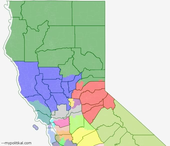
CA-1 (Blue):
Population - 59.6% white, 1.5% black, 27.3% Hispanic, 7.0% Asian, 1.6% Native American, 3.1% other
This district ranges from the vineyards of Napa Valley to the marijuana groves of Mendocino County. It covers a lot of space, but almost all the people live in the medium-sized towns and cities along the coast and dotted throughout the rest of the district (interestingly, it's a lot less white than I initially expected). Perhaps the biggest problem with this district is that it divides the city Napa in two, the consequence of decisions made elsewhere in the map.
It is possible to advocate for a coastal district stretching from upper Sonoma County to the stop of the state. This proposal decided not to do that for the sake of compactness; nevertheless, such a district would be well worth considering.
CA-2 (Green)
Population - 78.0% white, 1.4% black, 11.8% Hispanic, 2.4% Asian, 2.9% Native American, 3.6% other
This enormous district covers the northern-most portion of California. Like CA-1, there's a lot of land covered here - but most of it is just empty space. Most of the population actually lives along the coast and in Redding.
CA-4 (Red)
Population - 79.1% white, 1.0% black, 11.9% Hispanic, 4.2% Asian, 0.8% Native American, 3.0% other
This district is composed of two entities. First are the exurbs of Sacramento, located in Placer County and composing the about half of the district's population. They are joined by the communities in the mountainous Sierra Nevada, too small by themselves to form a single district.
Sacramento
Sacramento County is populous enough to support about two districts.
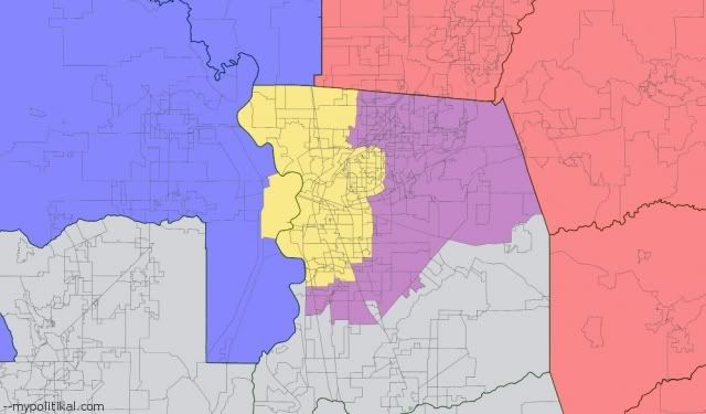
CA-3 (Purple)
Population - 57.3% white, 7.7% black, 16.3% Hispanic, 13.4% Asian, 0.5% Native American, 4.8% other
CA-3 previously constituted a very gerrymandered district connecting suburban Sacramento with a bunch of unrelated communities. Since suburban Sacramento's population has grown so much, it shrinks rapidly to compose only the eastern and southern suburbs of Sacramento.
CA-5 (Gold)
Population - 38.6% white, 12.3% black, 26.8% Hispanic, 17.2% Asian, 0.6% Native American, 4.6% other
Majority-Minority District
A wonderful example of California's amazing diversity, CA-5 takes in downtown Sacramento itself. Whites, blacks, Hispanics, and Asians are almost equally distributed - with whites composing a plurality despite being just 38.6% of the population. Moreover, this area is one of the most racially integrated in the United States; the district does not lump together a bunch of 90% white, 90% black, 90% Hispanic, and 90% Asian communities in one (as too often happens elsewhere). Rather, each people of different races actually live in the same neighborhoods.
The next post will take a look at the Bay Area.
--Inoljt
