This is a long diary, written mostly for the record. Approach it accordingly.
We are halfway between June 12, the day when California's Citizen's Redistricting Commission (CRC) was supposed to release its "Second Draft" maps and July 28, the day that the "Final Maps" are to be released. (They must be approved by August 15.) For those who follow the CRC closely, though, this last week has been anything but a slack period. We're down to the "short strokes." (That's a woodcutting term, by the way.)
I've generally liked the CRC's work so far, setting aside some truly jaw-dropping initial cuts at the lines (like putting Santa Ana with Newport Beach). The most impressive aspect of the CRC has been its transparency: we can see the districts take shape, see who the movers and shakers are and what they care about, and get some sense of the CRC's fault lines. It is not yet assured that any proposal will garner the three votes each needed from each group: the 5 Democrats, 5 Republicans, and 4 "others."
If they can reach agreement, that ends the process, except for the inevitable court challenges -- most of which I suspect won't be that productive anyway. Even if the lines are sent to a panel of judges, though, I suspect that, unlike in previous years, the work of the multi-partisan CRC would likely receive substantial deference in drawing final lines. The sheer amount of well-documented research that the CRC has done -- including collecting the bases for communities of interest and documenting expressed bases for any disagreements between Commissioners -- would give the judges a tremendous head start. So, either way, what we see at these late stages of the CRC's process are fairly likely, one way or the other, to be pretty much what we get.
So far as I can tell, it's probably too late for most of us to influence the commission. The work they have left to do, although it involves some major choices, is mostly along the margins. Nevertheless, I want to put the final lines I came up with for my home base of Orange County into the public record. I'm not sure what my doing so is worth, but at least it shows what might have been -- and if there are court challenges, at least these maps offer what I hope is one cogent alternative.
I'll address Congress, Assembly and Senate Districts in that order, followed by a preliminary look at what may be an especially consequential map: that for the State Board of Equalization. There will be maps. One comment about the maps up front:
One is not to consider the partisan implications for maps nor the residences of incumbents or prospective candidates. Accordingly, I have not done so. Some things are obvious -- Santa Ana is more liberal and Democratic, Newport Beach is more conservative and Republican -- but I have not even looked at the partisan breakdown or electoral history of the districts that I've constructed. (I take as given that Latinos in Santa Ana have had different voting patterns than non-Latinos.) I have been guided only by the statutorily required criteria -- including trying to honor "communities of interests."
I had planned on doing redistricting for the entire state at all levels -- hey, I like puzzles! -- and spent a lot of time doing so in March and April. The limitations of the publicly available free software provided for the task, however, made this difficult before release of the First Draft maps -- and, for me at least, literally impossible afterwards, as my computers simply refused to cooperate. I'll therefore address only Orange County.
If you want a sense of what the CRC is thinking, it's been important to follow not only their official First Draft maps but also what they call their "visualizations" -- usually partial studies of what segments of maps might look like. This critical information has been stored in a page on the CRC's website under the Meetings tab (rather than something intuitive like Maps), at a link called Commission Meeting Handouts. For the First Draft maps, the first set of visualizations (on June 1), which roiled the blogosphere and meatosphere alike, weren't a great guide to what the maps that eventually emerged would look like. The second set (on June 8), though, were close to the mark. Both have by now largely fallen to the wayside.
The Committee has been learning how to keep the public informed as it goes along, though, and that link above has some amazing resources for redistricting geeks and governance geeks generally. First of all, you can review every single comment orally presented to the commission in their running database of public comments, along with some written comments and attachments. The latest version of the database is here. For those who want to know what district they'll end up in, the innocuously named "Line Drawer's Notes" --chronicling discussion in detail, including who said what and what the Commission decided as a result -- are invaluable: here are the latest two installments as I write, for July 15 and July 16, both of which bear on Orange County's lines (and much else.)
Congressional Lines
The "First Draft" maps for Orange County, which came out in mid-June, looked like this:
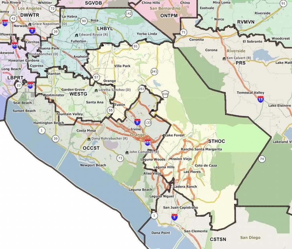
A few initial comments about this now-outdated First Draft map:
(1) It does not provide a district where Latinos, based on their projected Citizens of Voting Age Population ("CVAP"), could be expected to elect representation. The WESTG district put Santa Ana in with the Vietnamese area of Garden Grove and Westminster, ill-suiting both the Latino and Vietnamese populations. Santa Ana belonged to a "Community of Interest" ("COI") with areas like Central-to-West Anaheim and east Garden Grove, among some others. This is BAD.
(2) It breaks county lines minimally. The northern border and most of the western border of Orange County are respected, as is the depopulated eastern border. This is Good.
(2a) To the South, the cities that are put with Northern San Diego (across Camp Pendleton) are reasonably large and coherent, enough to have a significant say in that election. This is Good.
(2b) By contrast, to the west two cities, La Palma and Los Alamitos, are plucked out of Orange County and put with an LA district. They would have minimal influence on the election, especially as they aren't even contiguous. This is Bad.
(3) In other ways, the map does a good job of keeping regional areas together. Most of North Orange County is together. Most of the coast is together, although it extends inland into Irvine and Tustin. Most of what they call "South Orange County" (but which is actually East Orange County) is together, except for the excess at the bottom that required crossing borders. Except for messing up Santa Ana, it's a better map that what we've had now.
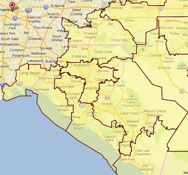
Here is the alternative proposal -- my second, as in my first I was trying to keep Garden Grove whole and that turned out to be pointless -- that I offered to the CRC:

The persimmon-colored lines approximate the boundaries of the First Draft maps. The five different colors for territories represent my proposed districts. Some comments:
(1) I maintain the same county borders as the CRC, except that I bring the two orphaned western cities back into the county. The South OC shared district remains the same.
(2) I "fix Santa Ana," putting it with central Anaheim and east Garden Grove, both heavily Latino areas as well as the western part of Orange.
(3) By splitting off Yorba Linda (which is similar to Anaheim Hills) from Brea (which is similar to Fullerton), I create a more culturally cohesive Eastern OC district. I'd even be willing to cut further into Brea, up to Rose Ave., which is essentially an extension of the 55 freeway.
(4) The coastal district now includes Los Alamitos and excludes the part of Irvine that is more akin to Tustin, while retaining the part of Irvine that is more like Newport Beach. The exact border (between green and blue) is wavy in the map, reflecting that it would need to be determined precisely to equalize population.
(5) The big problem in OC has been: if you give Santa Ana a Latino district, what do you do with North OC and the Vietnamese area? My answer is: curve around west Anaheim and combine them. While it's a pain to get from, say, Brea to Westminster or Fountain Valley given the lack of a north-south freeway between the 605 and the 55, it's not that bad. This district would, among other things, combine many Asian constituencies: Vietnamese to the South, South Asian to the northwest, Chinese and Korean to the north. It also includes most of the Latino areas that aren't in the Santa Ana district, although not enough to dominate, along with plenty of Caucasians. It would be an interesting and variegated district in which no one COI would dominate and no two COIs would be locked in a death match -- it would in many ways be a wonderfully multicultural place. Economically, western northern, western central, and Northwestern OC are also a pretty good fit.
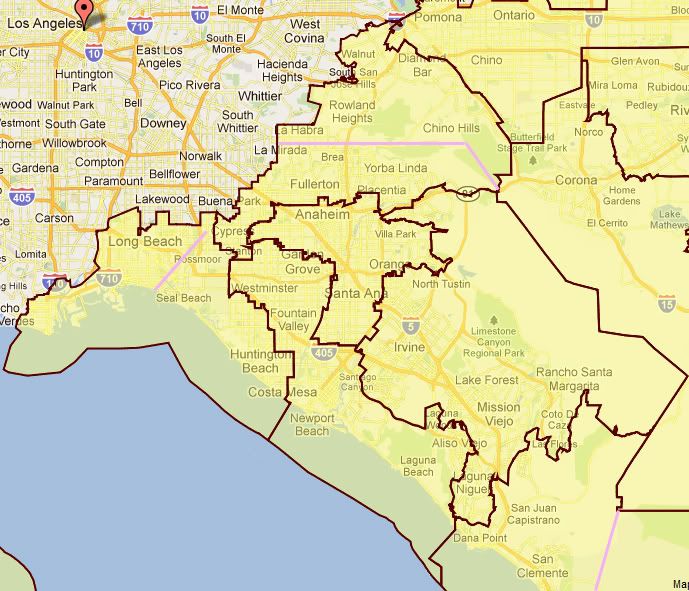
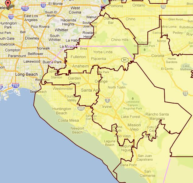
What did the CRC do? They give us three options, which in turn depend on what they do with LA's borders. Note that the lilac-colored lines approximate Orange County's borders (except in the northwest, where I wasn't going to bother drawing in the "staircase"). Let's start with the first two:
Option 1
Option 2
As you'll learn from the "Line Drawer's Notes" listed in the Intro, the Committee seems to be leaning towards Map #1. Or maybe it is Map #3. Possibly Map #2. It's not entirely clear. And, as you look at the recommendations in the right column, you'll see that some things are being moved around anyway, so I'm not sure these precise lines still hold up. Some comments on Options #1 and #2 first:
(1) Maps #1 and #2 pretty much take care of the "Santa Ana problem," although they also include highly Republican Orange. (The Republican Mayor of Orange herself suggested that they go only as far as the 57 freeway, which I think is reasonable. At least not beyond the 55.) They also both connect the Vietnamese community of west central OC with Costa Mesa, Newport Beach, and Laguna Beach, which is (a) good news unless you live in relatively Democratic Laguna Beach and (b) probably a way to ensure that Republicans get elected -- but not necessarily Vietnamese ones. Westminster and Fountain Valley really belong more with Huntington Beach than with Newport Beach, but in my opinion what's driving this map is considerations deriving from LA County, which needs to borrow Huntington Beach for another decade or so.
(2) On the western border, they still -- apparently because they just can't help themselves -- move La Palma into an LA district. Further southwest, though, things change considerably. Both maps combine the southwesternmost parts of OC -- Los Alamitos, Rossmoor, Seal Beach and Huntington Beach -- into what is mostly a Long Beach district, including the Port of Long Beach, either alone (#1) or with some of Palos Verdes (#2). Because "Huntington Beach to Palos Verdes" was one of the curse words of the past decade, I suspect that #2 is less likely.
(3) The changes to the eastern and southern OC districts are not huge (and to me, at least, mostly mystifying and suboptimal, but evidently someone spoke loudly enough to get them.) It's in my beloved North Orange County that they go wacky. Those districts stretching from Chino Hills (in San Bernardino Co.) to Walnut (in LA Co.) to Buena Park (in Orange County) -- or even further to Cerritos, in Map #2 -- look relatively compact don't they? And they would be nicely compact if it were not for the Puente Hills crossing most of the distance of that lilac-colored line across the top. (The line should possibly be a little higher, by the way; that, or the caption for La Habra should be lower.)
I don't mention this because it is so hard to drive over the Puente Hills -- although between Whittier and the 57 Freeway (just right of the "Brea" caption) there are only two windy hilly roads that cross them and there's even less east of the 57 -- but because it makes a mockery of the notion of a "Community of Interest." There just isn't a "Community of Interest" between northern and northwestern Orange County and the San Gabriel Valley areas on north slopes of the Puente Hills, let alone as far north as Walnut. (They even load in Hacienda Heights to the west.) We don't know each other; we don't do politics together; we don't even often travel to each other's areas (and, if you've ever driven on the 57/60 at rush hour, you'll know why.) For most North Orange County residents, these San Gabriel Valley communities are places one drives through on the way to downtown LA, if one doesn't want to be parked on I-5 for a long time, or up to catch I-10 to Santa Monica or Ontario.
I wondered what caused this to happen, and in reading through the testimony and submissions I finally figured it out. North Orange County (with a very few exceptions like me) did not mobilize to push for its community interest here. Our County's interest was preserving Latino districts in the central county. Based on the first maps, we thought that we'd be pushed south (as my map does) or west (into Whittier, La Mirada, etc.), which would have been fine. Why were we lumped with the north and east, then? It appears to me that it's because that's what the wealthy folks from Diamond Bar and Chino Hills wanted. Diamond Bar wanted to be with Brea. Diamond Bar wanted desperately to be with Brea. Why did Diamond Bar want so badly to be with Brea? Well, I have a hypothesis: Rep. Gary Miller.
When the First Draft maps came out, there was much hooting and hollering over how Gary Miller no longer had a district. The celebration was premature. Miller's 42nd district currently includes La Habra, Brea, Yorba Linda, Placentia, Chino Hills, his home of Diamond Bar, and the north slope areas such as Rowland Heights. That's most of the district. Tossing in a few relatively Democratic areas like Walnut and Buena Park won't hurt him much. Fullerton could be a problem, but it's generally Republican and its rep, Ed Royce, has already said that he wanted to look to the East OC district rather than slug it out in a competitive North OC district. Now, he'd have a winnable district -- but he'd also have Gary Miller in the way, with more of the population being his previous charges. I think that Royce is moving on -- although I'd love to see him and Miller in a cage match.
This is, shall we say, an impermissible intrusion of political considerations into the process. And yet, I don't blame the Commissioners (except maybe Michael Ward) -- they were responding to a concerted and facially apolitical effort to testify by the Diamond Bar and Chino Hills elite. North Orange County and places like Walnut didn't speak up. The pretense that this would be an Asian-influenced district, when the Asian communities on either sides of the Chino Hills are in limited contact, was probably enough to make it compelling. In other words, we got rooked.
Option 3
Option 3 is apparently still in the mix -- and controversially so. This map more closely follows the line of the western OC border (although we bid adieu to Buena Park and maybe some or all of La Habra) and keeps Long Beach on its side of the border (to the great relief, as I understand it, of Long Beach.) It pushes the border in Santa Ana's district Orange to the 55, where I had had it. The Santa Ana district now extends to Cypress, bringing it more Latinos from western Anaheim and Stanton. The coastal district unites Huntington and Newport Beaches and their neighbors (as well as, for some reason, Laguna Niguel); the eastern district gives up Anaheim Hills (also Gary Miller territory) to the north as it takes on Orange. While picking up Anaheim Hills, the northern district loses Walnut and perhaps part of Rowland Heights. Overall, these changes make the district even more safely Republican, despite the presence of western Anaheim.
Of the three plans above, my preference is: none of them, although especially not #2. If anyone wants to go to court, you see my suggestion above.
Assembly Lines
I start with Assembly District lines rather than Senate District lines because the former were supposed to be nested within the latter. That's "were." The CRC has evidently realized that while nested districts are nice, they aren't actually required, and is prepared to take advantage of that freedom.
I nested mine. Here they are:
As you can see, North Orange County (in pink) is bounded on the east by a line stretching north roughly from that of the 57 freeway. Central Orange County (in orange) is the Latino-dominated district OC needs. West Orange County (yellow) contains the Vietnamese area and the neighboring coasts. The Central Coast (green) from Beach Boulevard to Laguna Beach, is a wealthy and coherent district. Eastern Orange County (turquoise), composed of eastern Brea, Yorba Linda, Anaheim Hills, most of Orange, Tustin, North Tustin, Irvine roughly north of I-405, and most of the canyons form another socioeconomically and culturally coherent district. South Orange County (blue) contains almost all of the cities thus described (Aliso Viejo and Laguna Woods being exceptions.) Finally, Northwest Orange County (purple), composed of Buena Park, La Palma, Cypress, Stanton, and westernmost Anaheim, would cross the Los Angeles County line into another largely Asian and Latino area, while retaining enough coherence to be an influential eastern half of that district.
Let's see what the CRC has come up with. They don't have their own countywide map, so I'll present the latest visualizations separately:
Anaheim-Fullerton

This is an interesting, multicultural district: half-Caucasian, almost a quarter each Asian and Latino, though "Asian" here covers a variety of cultures. It's nicely compact; there's a logic to it. It's much like the "purple" district I have above, but connected with Fullerton and more of Anaheim rather than with LA.
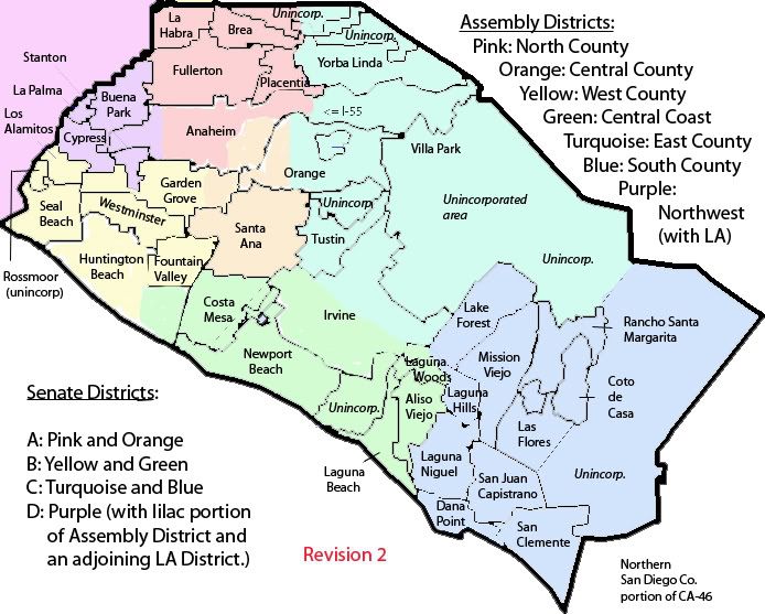
West County
This is quite similar to the yellow district I set up, including the Vietnamese areas and the northern part of the coast -- but not Huntington Beach! What's there instead of Huntington Beach? Well, it's not on the map, but, as you're about to see: it's Costa Mesa. Its appearance will speak for itself.
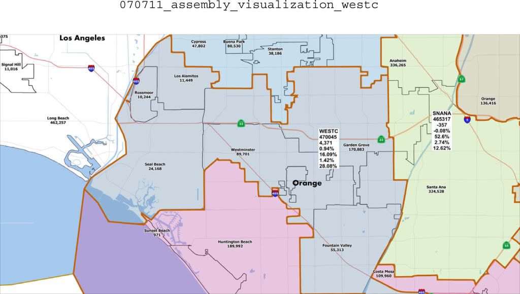
Central Coast
Here we go, the Central Coast district, including Huntington Beach and rolled up around, but not including, Costa Mesa. (It also includes more of Irvine than I do, up to I-5.) Not a bad district -- just a puzzling choice regarding Huntington Beach.
South OC
Take Aliso Viejo, give away Lake Forest -- not how I'd do it, but it's reasonable. Let's head north.
Tustin-Orange (aka East County)
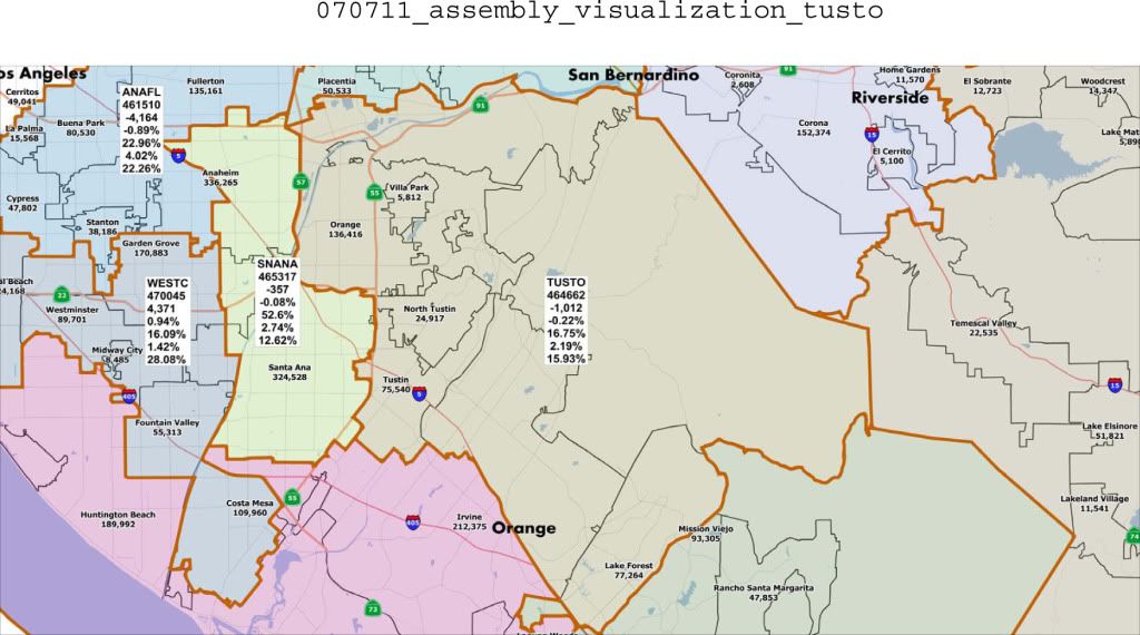
A reasonable looking district. They added Lake Forest and subtracted Yorba Linda from what I proposed, but it's pretty much coherent.
Santa Ana-Anaheim
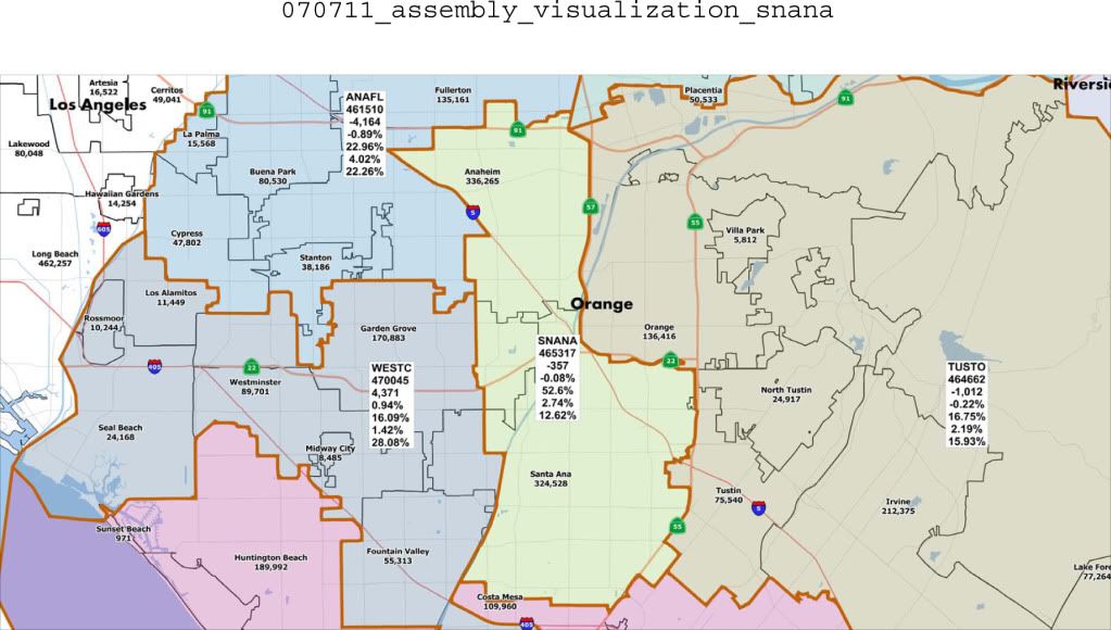
This is, of course, the Latino district that we demanded be included in the OC Assembly maps. Looks good. Well, so far, I don't see a whole lot to complaint about. Six down, all reasonably coherent, all reasonably compact, that should mean about half a district left to complete the county. Let's see....
North Orange County and Beyond

Oh. My. God.
I'd like to think that I'd recoil from this district like a skull-full of maggots even if it weren't mine, but as it is I have to take it personally. Most of the comments I made up there about the Congressional district apply here as well, but this is simply bewildering.
I'm sure that this was a simple error, but this monstrosity was omitted from the visualizations put out on July 8, possibly because it physically hurts to visualize it. To cover the entire thing, I had to piece it together like a Frankenstein's monster in Photoshop over the course of several hours, using no less than six maps from adjoining districts as source material. At some point, I just gave up on trying to make it look less ugly. It's ugly. Actually, it's Ugly's uglier cousin.
Go ahead and plug into your mapping program how you'd get from La Habra to Chino Hills. You see that freeway down at the bottom? That's probably it. The straight line between the two? That's tall hills with no east-west road. You can cross the hills above, of course. From Yorba Linda to Walnut? I don't even want to think about it. I don't even know what that area above Walnut, near San Dimas, is.
East of the 57, one can argue that there's a community of interest here: rich people in the hills. But the three cities other than Yorba Linda don't have a whole lot to do with the cities across county lines, except that people from Diamond Bar and Chino Hills will come to the Brea Mall to shop. The wonderful polyethnic (and politically unorganized) East Asians in Diamond Bar and the Filipinos of Walnut have little to do with even the Asian communities, scattered as they are, south of the Puente Hills. So why does this look this way?
Simple: Diamond Bar, in particular, asked for it.
And why did they ask for it? Because they are surrounded on almost all sides other than this by Democrats -- largely Latino Democrats. So the theme to the pudding of this district is: lots of Asians, but still about half-white. Diamond Bar gets its way. Yorba Linda is happy. La Habra and Walnut can wait for representation until after the next census.
Senate Lines
My Senate lines are found nested in my Assembly map above. One district is Santa Ana on up (my pink and orange). One is most of the coast (my yellow and green). One is everything east of the 55 (my turquoise and blue). The last one in the northwest (my purple), which would stretch into a district that was 3/4 Los Angeles, largely Latino with some Asian.
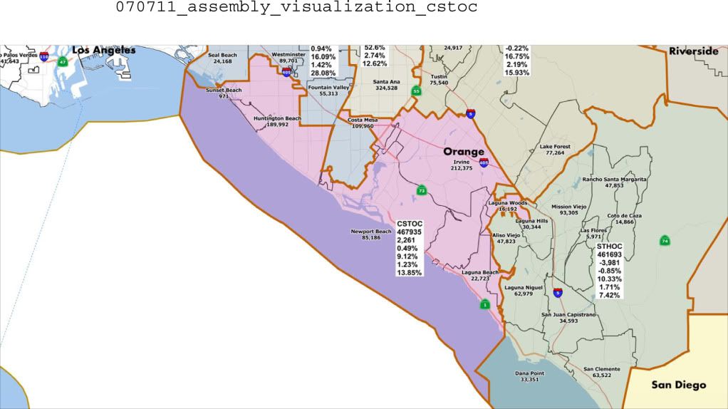
South and East County
What did the CRC come up with? Well, it ain't nested and it ain't pretty.
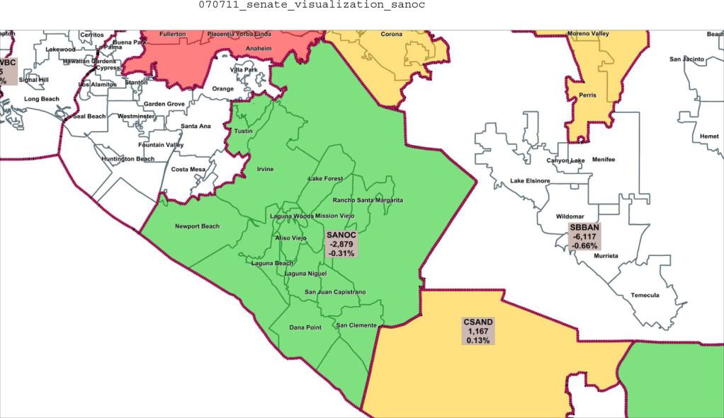
They call this one "SANOC"; I have no idea what they mean, so I'm calling it what it is: South and East OC. It's a decently coherent district. Woe betide the Democrat who runs here.
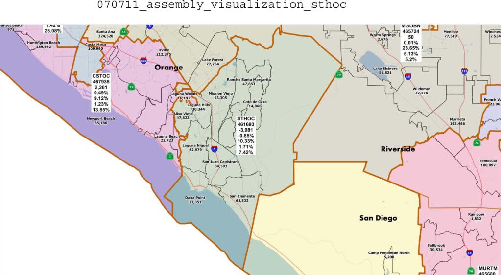
Central and North County (and North)
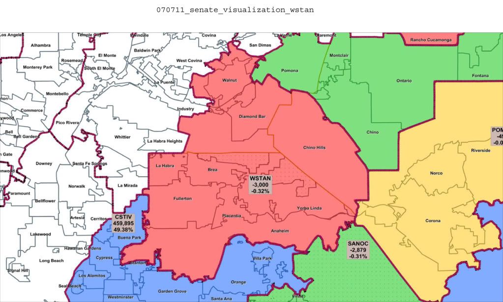
Pretty much the same criticisms here as with the other districts that cross the Puente Hills. It would be a more coherent district if they left out West Anaheim and took in East Orange. Does Villa Park really want to be with Santa Ana?
One thing to notice about this map isn't in the district itself: it's the legend for the district in blue, which shows that it's about 50% over its appropriate population. That means that only 2/3 of what isn't in the above two maps will be in one district, and the other will be sharing a district with LA.
West and Northwest and Southwest County -- and Long Beach?
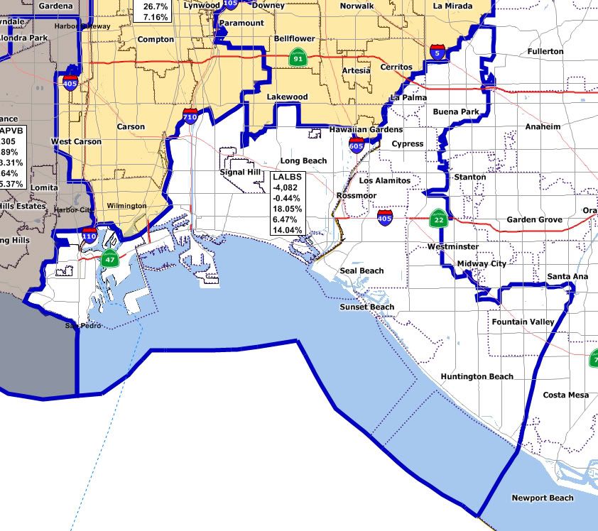
There's no visualization offered for that blue district with the duck head facing east, so all we can rely on to give us a sense of the final lines is this map from Los Angeles. This map shows that Long Beach is to be tied to cities in the west, as far north as Buena Park and as far south as Fountain Valley and Huntington Beach. As long as OK gets outvoted, it's OK.
By process of elimination, this leaves the final district containing Santa Ana, Garden Grove, Westminster, Costa Mesa, Stanton, Orange, and Villa Park. I don't know what they call that district, but I call it a lawsuit waiting to happen.
Board of Equalization Lines
These are just screwy -- and in some ways they bother me most of all. I'll get to most of it another day. For now, I simply want to propose a question to you all.
California has about 38 million residents. The Board of Equalization has four seats. You would think, then, that each seat would thus represent about 9.5 million residents.
Now the 2010 census gave us some very easy to remember results here in Southern California:
Los Angeles County is about 10 million people.
Orange and San Diego Counties are about 3 million apiece.
San Bernardino and Riverside Counties are about 2 million apiece.
Imperial is about 150,000; I think that it and LA actually add up to 10 million.
That being so, take a look at the green-shaded district below, which contains almost all of Los Angeles and Orange Counties.
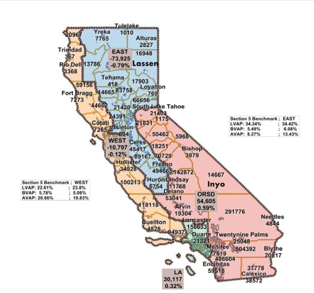
My question to you is: how is that district possibly only about 9.8 million people?
If I'm wrong in an assumption, please let me know below. Because, the way it looks to me, this may be set up to provide a 3-1 Republican majority on the BOE. It's the one that I most think may warrant a lawsuit.
UPDATE 1 It seems to me that there's got to be something wrong with the map itself. Here's what the county-by-county breakdown says of LA County's placement along the districts:
County: 06037 Los Angeles
District EAST 3,172,335 32.3%
District LA 6,497,212 66.2%
District ORSD 149,058 1.5%
City subtotal 9,818,605 100.0%
Unless I am very much mistaken, not only does Los Angeles County appear to be whole in that visualization with the exception of the Palmdale area, but it doesn't even border the EAST district that supposedly has a third of its residents. Someone should fix this; I'd like to see the actual map, please!
