To the untrained eye, the current Massachusetts map looks needlessly ugly. After all, Democrat's control of the state (minus a long run of Republican governors) is legendary. It is often thought that the gerrymandering is more a result of incumbency and turf, and not partisan politics.
This is wrong. It is quite easy to draw at least two Republican districts in Massachusetts.
While DRA does not have Massachusetts partisan data, the Boston Globe does have up a sheet which has the vote totals for every city and town in the state. Although a bit more cumbersome, it is possible to use this to come up with district PVI - provided you do not cross town lines. The map below keeps entirely within towns, and thus has a high variance (up to 5,000) but could be easily fixed with access to real partisan data.
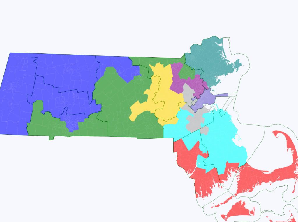
There are two districts on the map which are Republican leaning: MA-2 (Green) and MA-9 (cyan). Both have PVIs of R+2.
MA-2 contains the more Republican-leaning parts of Hampden, Worcester, and Middlesex Counties. It stays swingy because there is no way to put the City of Southbridge (an old industrial mill town) into another district, along with Democratic-leaning cities like Longmeadow in which must be included to connect the Republican-leaning suburbs to the west of Springfield.
MA-9's core is Plymouth County (minus the industrial city of Brockton, which has a high Black population), along with the right-leaning parts of Suffolk and a few Republican towns in Bristol. Essentially every town here has a Republican PVI, minus a few which are very narrowly Democratic which were added to smooth out the northern border and reach population equality.
Although these two districts comprise most of the Republican-leaning towns in Massachusetts, there are a number which do not fall into either district, particularly in Essex County. While three Republican-leaning districts are likely impossible, three districts which are toss-ups seem quite plausible.
Going in order:
MA-1 (Blue) - 72% Obama
MA-2 (Green) - 52% Obama
MA-3 (Purple) - 67% Obama
MA-4 (Red) - 62% Obama
MA-5 (Yellow) - 62% Obama
MA-6 (Turquoise) - 61% Obama
MA-7 (Grey) - 68% Obama
MA-8 (Light Purple) - 79% Obama
MA-9 (Cyan) - 51% Obama
Now, is such a map likely? No. But slightly less convoluted versions of MA-2 and MA-9 could easily be made by a neutral redistricting process, seats that a Republican would, if not be favored in, be very competitive. Indeed, there is a real reason why the South Shore and the Worcester area are chopped to bits currently.
Just some food for thought.
Feedback?
