In the 1970s, Portland, Oregon decided to reject construction of additional freeways and apply the $500 million in federal funds (this took some wheedling by then mayor, the now-disgraced Neil Goldschmidt) to building a business transit mail downtown and a rail mass transit system. The first leg of the rail system, called MAX Light Rail, was completed in 1986.
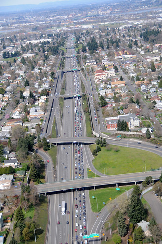 I-5 in Portland Oregon, looking north. A classic illustration
of the futility of freeway transport for mass transit. Neighbor-
hoods are destroyed, while a miles-long traffic jam forms
on the roadway for which the neighborhoods were sacrificed.
©WSDOT, limited reuse per CC BY-NC-ND-2.0.
The original plan of the Oregon Highway Department developed in the 1950s was to build a whole network of freeways in Portland. Some of these were built, with I-5 in particular punching right through the only African-American neighorhood in Portland. (See here for a
map of the built and proposed freeways.)
One proposed freeway was the Mount Hood (aka "the Highway to Hell"), which would have run from the world's ugliest bridge (the Marquam over the Willamette river) east along along a route two blocks wide running between present Division and Clinton streets, to 52nd street, where it would have met the proposed 52nd Street freeway, then SE to to a route along present-day Powell Boulevard and then E to the city of Gresham. Present day north-south 20th Avenue, then and now a two-lane residential street, would have been converted into an "expressway" accessed via a cloverleaf intersection.
Clearance of the right of way would have required condemnation and destruction of 1,750 residences, about 1% of the housing stock of the city.
Substantial steps towards this were made. One-quarter of the properties in the freeway's path were acquired by the Oregon Highway Department, and some housing demolition had begun. Here is a blog with some images of the route the freeway would have carved through the city.
The whole thing could have been cooked up by an evil cartoon:
Judge Doom: A few weeks ago I had the good providence to stumble upon a plan of the city council. A construction plan of epic proportions. We're calling it a freeway.
Eddie Valiant: Freeway? What the hell's a freeway?
Judge Doom: Eight lanes of shimmering cement running from here to Pasadena. Smooth, safe, fast. Traffic jams will be a thing of the past.
Eddie Valiant: So that's why you killed Acme and Maroon? For this freeway? I don't get it.
Judge Doom: Of course not. You lack vision, but I see a place where people get on and off the freeway. On and off, off and on all day, all night. Soon, where Toon Town once stood will be a string of gas stations, inexpensive motels, restaurants that serve rapidly prepared food. Tire salons, automobile dealerships and wonderful, wonderful billboards reaching as far as the eye can see. My God, it'll be beautiful.
More on the struggle between the hobbit citizenry and the Freeway of Sauron, and its ultimate results below the fold.
Following a long struggle (see here for a comic book version), the community was able to prevent the Mount Hood Freeway from being built, although as a compromise, the 52nd avenue freeway was built, but further to the east, at about 92nd avenue, and became known as I-205. Here's a link to a 2006 video from streetfilms.org which compares the implemented freeway projects in Brooklyn, NY to the similar but unimplemented projects Portland. It's a bit propagandistic, and somewhat dated in terms of the current light rail / bus mall situation, but I think it gets the point across.
Modern plans for the area
The many years of uncertainty over the area's future had inhibited both both business development and residential construction. Since the area had been considered to be a low-rent district in the first place (and thus eligible under the thinking of the time to be replaced with a freeway), this man-made blight had made things all the worse.
Since that time there has been a bit of a rebound. The city has developed, as they have for many other areas, a comprehensive development plan for Division street, see here (.PDF). Division is intended to be a "Main Street" with commercial intensive zones at intervals, and an emphasis on mixed commercial and residential use throughout.
Clinton Street, basically parallel to and two blocks south of Division, has been designated by the city's transportation bureau for special enhancements for bicycle use.
 Image 1: Mixed use structure in lieu of freeway cloverleaf
 shows a dual use structure located on the north side SE Clinton Street, near SE 20th Avenue in Portland, Oregon. There are four dwelling units located above commercial premises. This structure is located on a long narrow lot back from the street. One can see the attractive nature of the open two-story main room in the dwelling units. The cloverleaf interchange for the 20th Avenue expressway would have been at just this point. Instead nowadays a bus route, Line 10, runs south down 20th Avenue and turns east on Clinton, immediately to the right of Image 1.
 Image 2: In-fill housing on formerly projected freeway
 shows on the left side an in-fill single family residence. The new residence is staggered back from the street, giving it a better sense of privacy. There is no provision for a garage in either residence shown here, although both residences are located within easy reach of bus routes which run east and west along Division Street (Route 4) and Clinton (Bus 10). Construction of the Mt. Hood freeway would have required the destruction of every structure in this image.
In-fill housing has been encouraged by the city, and has attracted national attention (See here for a
HUD-sponsored report (.PDF)).
 Image 3: Residential use over business, upper floors overlook city
rather than freeway shows a mixed-use structure located at 3103 SE Division Street in Portland, Oregon. This is very close to the houses shown on Image 2, and about 10 blocks to the east and two blocks north of the structures in Image 3.
The building shown in Image 3 has twelve dwelling units placed above 8,000 sq. feet of commercial space. This was built over a substantially reconstructed building that once housed the Reliable Auto Parts, and is still called the Reliable Building. The developer has a detailed webpage, with more detail. Image 3 also shows new multi-use structure under construction on the right.
Had the Mount Hood Freeway been built, this section of Division Street would have been designated a "frontage road". The point from where Image 3 was taken would have been just on the edge of the drop off into the freeway trench, making the whole area much less attractive to investment in construction such as the Reliable Building.
 Image 4: Residential use over business, separate structures
connected by multi-story breezeway. shows the
3810 Building, on the south side of Division, and therefore well within what would have been the westbound lanes of the freeway.
This remarkable building is actually two structures connected on the top three floors by a multi-story glass-walled breezeway. Commercial space is on the lower floors, and one can walk into a quiet well-garden plaza to access businesses located in the rear of the structure. Although there are 24 residential apartments, there is no space provided for off-street parking. The idea of the developer is to appeal to people who prefer to use mass transit or bicycle as their primary mode of travel.
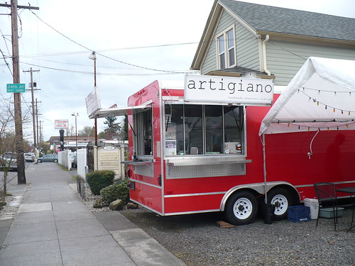 Image 5: A new food cart on Division street, attracted by better
business opportunity. shows one of
Portland's ubiquitous food carts, one of the most beloved features of the city. I spoke with the owners of this particular food cart, which is a striking red color outside, and has a wonderful stainless steel modern kitchen inside, and they told me they'd relocated to Division Street a couple months ago.
These folks were serious people -- you have to be of course to be successful in this trade, and in their late 20s. They said business was better here, on account of the many businesses and new development projects in the area, and they felt it would support their somewhat higher priced menu. The food cart nation is of course highly oriented to twitter and social media for promotion, this particular cart receiving good reviews here .
On larger scale, the coming of this food cart to the area to be a good sign -- the cart itself clearly represented a substantial investment of money for the young owners, and they had chosen their site with care. Could the presence (or absence) of food carts in a community be a macro-economic indicator? If it is, y'all owe me a Nobel Prize.
Personal observations
In researching this diary I walked around the neighborhood. I ran into a fellow named Dennis working on his house in what would have been the Mount Hood freeway and I got to talking with him about the freeway proposal. He said the area was the only place they could afford, and at the time house prices were down in the vicinity because the state had condemned so many properties in the area for the freeway right of way.
I zigzagged up and down the neighborhood streets walking between Clinton and Division Streets. Division is a busy street, with much new development. But there are still signs of underuse, a vacant lot where an auto repair shop burned, an unfortunately closed former Japanese restaurant with a vacant parking lot.
There's even a porno theater, a rare survivor in the days of the internet. this particular theater was built in 1926, I'm sure as an ordinary establishment. By the 60s and 70s according to this blog, it had shifted over to a porno format, complete with a since-removed classic garish neon sign. This seems to be a holdover from the lower level of economic development in the community at that time.
Over on Clinton Street, where a streetcar once ran back in the day, the traffic is much less and slower. (Clinton you'll recall marks the southern edge of the projected freeway right of way). Clinton street is mostly residential, with a combination of older duplexes and apartments, some infill, and also a number classic bungalow style houses. Clinton Street is definitely much safer for bicycles, with speed bumps and traffic islands to keep down vehicular traffic.
Portland now gives names to the east-west roadways, like Division and Clinton, and calls them (mostly) "streets", but gives numbers to the north-south roadways, and calls them (mostly) "avenues". However, the concrete pours in the area show that the now ho-hum numbered avenues once had names of their own, and these can still be read, such as "Kenilworth" in the concrete.
The contractors also were proud to show their names in the concrete pours, as well as the date of the work. I saw "1911" quite a bit. (There is actually a monograph on this!) Some Portlanders seem to love the old names and the sidewalk dates, see here for a blog with a lot of photos.
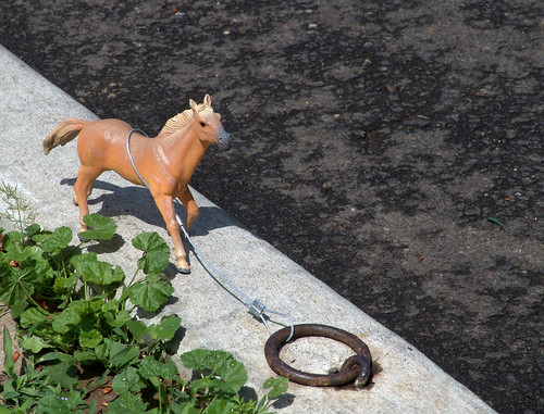
Back in 1911, horse-drawn transport was still common, and one still sees the curbs protected by steel angle-irons, which was necessary to keep the steel rims of cartwheels from destroying the concrete curbs. Horse rings are still common, my house has one.
Conclusion
Please notice that the decision to build the freeway, the decision to abandon it and emphasize other transportation alternatives, and the later revitalization of the community, have spanned almost 50 years of time. Decisions we make today will have similar effects over similar time scales.
In my earlier diary on the Portland Street Car, I mentioned that the street car was not a magic potion to cure a city's problems, but it could be part of a solution.
Another key solution, which I hope to have shown here, is the encouragement of local small business, you can see this throughout the area I have described. These generate local jobs which cut down on the need to build transportation infrastructure. Also, a large number of successful smaller businesses will IMHO be a more stable economic base than one or two large businesses, which, should they fail, will take down the entire community with them.
Avoidance of destruction of significant portions of a community for freeways, and instead conversion to more densely populated areas served by mass transit, and deemphasizing the private automobile, can contribute further to an improved quality of life in the city.
It's right to be guarded about too much urban planning, as that in the 50s and 60s that became a code word for neighborhood destruction as opposed to what was really needed, which was neighborhood revitalization.
But it won't do to call a city's planning for neighborhood development socialism -- that wasn't what we heard when cities were being diced up into pieces by freeways. And surely it is just as much socialism to favor a policy of constantly expanding suburbs, consuming more and more resources, both in land and in public construction of roads, schools, etc., while leaving behind a zone of decay and civic neglect.
One of the finest books on this topic is The City in History (1961), by Lewis Mumford, and the point of this book, if I understand it correctly, is that people's lives and philosophy are organically linked to the cities they live in, and vice versa, and if, as a primarily urban society, we wish to change or control our lives, then we must seek to change and control the development of our cities.
I mentioned the sidewalk dates and contractor names. Of course in our world of time-pressure and constant demands, one has little time free to spend on such concerns. But I think there is a need for a sense of history and community, and this is why we are encouraged to be able to look down to see instantly when a sidewalk was poured, and the names of the people who did the work.
Well, that's all for now. What do you think?
Pax.