TransCanada is back with a
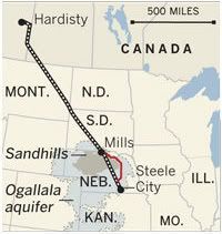
revised route (pdf) for their proposed Keystone XL pipeline through Nebraska. The new route takes a jog to the east, but still crosses the fragile Nebraska Sandhills and the vital Ogallala Aquifer.
In fact, "the Ogallala underlies most of the proposed re-route," the TransCanada report noted. The Los Angeles Times describes the Ogallala as "the nation’s most important agricultural aquifer."
Previously, President Obama rejected the original route in January, explaining "the rushed and arbitrary deadline insisted on by Congressional Republicans prevented a full assessment of the pipeline’s impact, especially the health and safety of the American people, as well as our environment."
Earlier, the State Department ordered a review of alternate routes that would avoid Nebraska's environmentally important Sandhills region and the state's Republican governor, Dave Heineman, wanted the pipeline to be routed around the Ogallala Aquifer.
So what has changed with TransCanada's newly revised "preferred alternative" route?
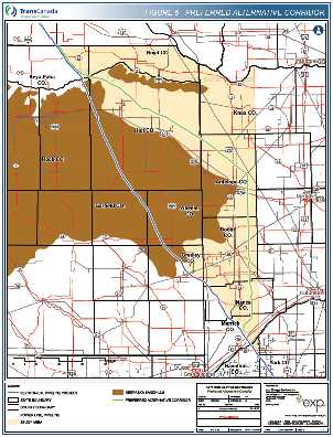
The brown area is identified as the Sandhills. The blue line
running diagonally from the NW to the SE is the Keystone XL path.
The green line to the east, is the new "preferred alternative".
Source:
TransCanada, (Click
map to enlarge)
Not much.
According to the LA Times, the revised pipeline route "avoids those areas of the Sandhills where groundwater lies under porous grasslands extremely close to the surface." But still, the pipeline would cross over areas where the groundwater is less than 20 feet below the surface.
The revised route avoids area of the Sandhills as defined by the state of Nebraska. Jane Kleeb of BOLD Nebraska, "a group of environmentalists, ranchers and other citizens fighting the pipeline," explained to the LA Times that actually the Sandhills extend farther than what the state map shows.
"I am literally standing with a landowner whose land this pipeline still crosses in the Sandhills. So unless I am standing on a mirage, it still crosses the Sandhills. If Transcanada cared about our state, landowners, water and Sandhills they would have proposed a safer, more responsible route instead of trying to play games with landowners," Kleeb said in a statement on the group's website.
Nebraska just this past week decoupled coordination of the pipeline approval from the State Department, requiring the Nebraska Department of Environmental Quality (NDEQ) to review any currently proposed or future pipeline route, the Omaha World-Herald reported on Tuesday.
Nebraska's review of the pipeline halted when Obama rejected TransCanada's original route. Heineman said the new law, which went into effect on Wednesday, will make the pipeline review NDEQ's top priority.
Kleeb told the CS Monitor that change in law is part of the effort by TransCanada to get the State Department to approve the federal permit. "They're trying to do is get Nebraska to get rubber stamp this route so they can then go to the State Department and say: 'We've solved Nebraska's problem, they've approved our route, so now give us our permit.'"
According to the Monitor, TransCanada and Heineman trying to "apply fresh pressure on Mr. Obama during an election year" and "Republicans in Congress are considering an attempt to wrest authority for its review from the Obama administration."
While the Senate is unlikely go along, House Republicans have put language into the the transportation bill to require federal approval of Keystone XL if the State of Nebraska approves the revised route for Keystone XL, the Washington Post reported. The White House has threatened to veto the bill.
The new Keystone XL route has the "same risks, same threats", a National Wildlife Federation's blog post said on their website. The pipeline "would still carry the most carbon-intensive fuel on earth to Gulf refineries. It will still leak, and it is still a threat."
An oil spill from the Keystone XL pipeline could contaminate part of the Ogallala Aquifer, potentially putting at risk Nebraska's water supply. The aquifer covers eight states and 30 percent of the groundwater used for irrigation nationwide. It is already threatened by depletion from its water being used faster than it naturally can be recharged. Unless its use is changed, the NY Times reported, "some geologists fear it could dry up in as soon as 25 or 30 years".
"Folks in Nebraska like all across the country aren’t going to say to themselves, ‘We’ll take a few thousand jobs if it means our kids are potentially drinking water that would damage their health,’” Obama said this past November. "We don’t want, for example, aquifers to be adversely affected. Folks in Nebraska obviously would be directly impacted."
Furthermore, the Sandhills are visited every year by 650,000 migrating Sandhill cranes. Visit Nebraska, the state's tourism website, describes the crane migration as "one of the great spectacles of the natural world... by day, the huge grey clouds of birds forage over and on Nebraska cropland. Come dusk, they swoop into the Platte River valley, where they roost for the night."
Shifting the Keystone XL a few miles to the east does not solve the problems raised by the original route. Despite the pressure from Big Oil and their Republicans, President Obama must continue to block the pipeline from being built.