
Radar estimated 70-95 MPH winds tearing across the DC area on Friday June 29, 2012.
It's been a couple of days since the powerful storms that tore an 800 mile path across the eastern part of the country on Friday afternoon and evening, and as more people from Illinois to Delaware have their power finally turned back on, many of them are asking questions about exactly what happened. I'd like to try and clear up any misconceptions and questions you have about the derecho. I'll try to answer some of the common things I've seen people ask. If you have questions, no matter how "simple" you think they are, ask. That's the only way you'll know.
What is a "derecho?"
A derecho is a powerful line of thunderstorms that produces wind damage over hundreds of miles. This line of thunderstorms is normally known as a bow echo -- the line tends to bow out at the center due to the very strong winds within the complex. Check my diary from both Friday night as well as from an event last summer for more information about derechos. For detailed information from the experts, check out the "About Derechos" page from the Storm Prediction Center.
What weather conditions favor derechos?
There are two kinds of derechos: serial and progressive.
A serial derecho is probably the type most everyone is familiar with. They occur during the spring and fall months when powerful cold fronts move through. These strong cold fronts can fire off a long line of that can produce wind damage over huge areas. Some more well-known serial derechos occurred along cold fronts in October 2010 and April 2011.
A progressive derecho, on the other hand, occurs during more quiet synoptic (overall) conditions. They frequently occur when a high pressure is sitting over the southeastern United States. This high pressure, also called "ridging," creates a boundary between calm and hot conditions and warm, relatively unstable conditions. The area around the top of the ridge provide focus for thunderstorms to develop. Wind shear and instability along and north of the ridge allow storms to form and organize into a line. The line is able to strengthen due to the amount of heat an instability available to it.
The storm on Friday was a progressive derecho. The storms formed in Iowa and Illinois, and slowly gained more organization until they exploded over Ohio. The storm raced southeast almost unimpeded until it hit the Atlantic Ocean.
How common are derechos in the Washington DC area?

SPC
They occur every few years. The most notable ones in recent memory occurred on
June 4, 2008 and just last Friday.
It's the government's fault it was so bad! Damn you, Obama!
No it wasn't. Use your brain before you spout off at the keyboard.
This derecho was a sudden wall of 60-100+ MPH winds that slammed a densely populated metropolitan area. Many of the power lines in the DC area (and elsewhere) are either partially are wholly above ground. The winds didn't gradually build up, they literally hit like a wall. This sheared trees in half, snapped telephone and power poles, and did structural damage. The mix of power lines falling down, and trees falling into power lines, caused a major power crisis not only in the DC area, but all across the area where the derecho hit. Millions were without power, and hundreds of thousands still remain without power while power companies scramble and struggle to replace damaged lines and restore electricity.
While the extent of the damage could have been tamped down a bit by investing in infrastructure and building a rather expensive grid of underground power lines, the damage would have been severe anyway. Just like the honey badger, mother nature don't give a crap. Even areas of the United States that are well prepared for this type of weather can experience utter devastation when a derecho comes through. Go back and look at what the July 11, 2011 derecho did to Iowa.
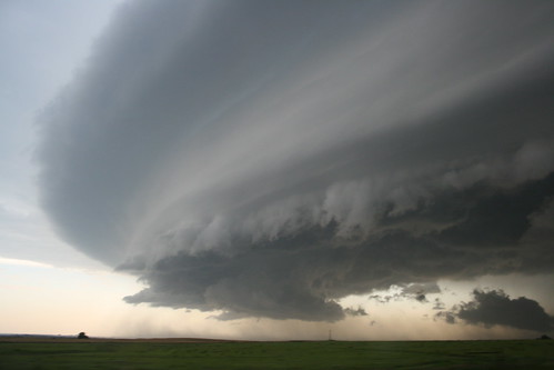
What was with the freaky layered cloud I saw right before the storm hit?
NOAA
That's called a shelf cloud. Shelf clouds form when the "bubble" of winds (called a cold pool) out ahead of the storm force warm, moist air up and above the cooler pool of winds. As the air ascends over pool of cooler air, it condenses in layers. The resulting cloud looks like a shelf. Appropriately, it's called a shelf cloud.
What can I do to protect myself from this and other types of severe weather?
It sounds clichéd and cheesy, but you need to have an emergency plan. Even if you don't write it out on paper and formalize it, know what you need to do in the event of a disaster like damage from severe weather.
Gather your personal documents together in one central location so you don't go running around looking for everything before or after a storm hits.
Know what you need to do in the event of a prolonged power outage like the one being experienced in the DC area recently.
Trim your trees back away from your house and other areas of your property.
Make sure that you're able to quickly tie down or bring inside loose objects outside that could become projectiles in strong winds. Something as simple as a flower pot on your porch could break a window or dent your siding if it flies around.
Always keep your cell phone charged.
Wear jeans and solid shoes if you know severe weather is coming. If something happens to your home or property, you don't want to walk around through debris in flip flops and short shorts.
When taking shelter from straight-line winds or a tornado, be mindful of what's around and above you in your house. If a storm is coming in from the west and you have a huge tree on the west side of your house, it's not a good idea to ride out the storm in an area where the tree would likely fall. Likewise, if you're sheltering from a tornado, keep in mind what's above you. If you are in your basement, you don't exactly want to be directly beneath heavy stuff like refrigerators or china hutches.
Keep track of the weather often and look at the Storm Prediction Center to see if your area is at risk for severe weather.
GET A WEATHER RADIO. Make sure it has S.A.M.E. technology, which allows you to program your county into the device and have it sound a loud siren and read the warning aloud when a warning or watch is issued.
Invest in a weather warning app for your smartphone. I highly recommend the iMapWeather Radio app for iPhone/iPod Touch. I have it on my iPod and it often warns me 30 seconds before my actual weather radio goes off.
You can keep track of your local weather using the National Weather Service and keep track of severe weather using the Storm Prediction Center. Remember, watches mean conditions are favorable for severe weather, and they're issued by the Storm Prediction Center. Warnings mean severe weather is imminent, and they're issued by your local National Weather Service office.
If you have any other questions, please ask them. The ferocity of this storm scared many people, and there's a lot of misinformation going around the internet about this system. As reality-based individuals, it's our duty to spread truth.
