The tragedy currently occurring in Syria is the focus of some degree of coverage in the media these days. However, most people know very little about the country, so I would like to provide some information about the country which might help those interested understand Syria and recent events a little better.
This is the second post in the series. The first can be read here.
I hope to write one more post in the next few days with a little more additional information about Syria.
Syria has an area of 185,180 sq. km (71,498 sq. miles) which is about the same as that of the state of Washington.
The population of Syria is reported to be between 21.6 million and 23 million depending on which source you read, which is about 10% less that the population of the state of Texas or about 10% more than the population of the state of New York.
About 46.5% of the people of Syria live in rural areas and about 53.5% live in urban areas.
- * - * - * - * - * -
- · Ethnicity and Religion · -
The number of Sunni Muslims in Syria ranges from 65% to 74% depending on which source you read.
The Sunni Muslims in Syria are predominantly Arab, but there are also Sunni Kurds, Turks, Circassians, Karbardas, and Chechens. The largest ethnic group in Syria is the Sunni Arabs, who are estimated to make up between 52 and 58% of the population of Syria.
The number of Shia Muslims in Syria ranges from 12% to 17% depending on which source you read.
The Shia Muslims in Syria are predominantly Alawites, but there are also small percentages of ‘Twelvers’, Ismailis, and Alevis. The Alawites are estimated to make up between 10 and 12% of the population of Syria.
The number of Christians in Syria ranges from 8% to 12% depending on which source you read.
The Christians in Syria are predominantly Levantines, but there are also small percentages of Assyrians, Chaldeans/Syriacs, and Armenians.
The number of Druze in Syria ranges from 1.7% to 3.2% depending on which source you read.
There are also very small numbers of Doms (Romani), Yazidis, and Jews in Syria, although some estimates put the number of Doms at about 1% of the population of Syria.
- * - * - * - * - * -
- · The Main Administrative Divisions of and Population Distribution in Syria · -
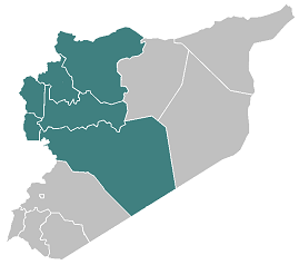
The population of Syria is concentrated in its southwest, northwest and northeast corners, and the central area of the country is empty barren desert. The northwest corner of the country has the largest population while the northeast corner has the smallest.
Syria has 14 governorates. These governorates are divided into districts which are then divided into sub-districts.
- - - - - - - - - - - - - - - - - - - - -
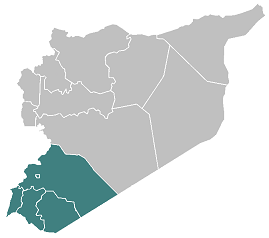
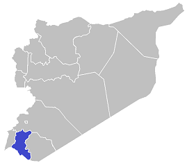
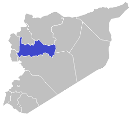
The population concentration
in southwestern Syria
In the Damascus, Rif Dimashq, As-Suwayda, Daraa and Quneitra Governorates
According to Syrian Government statistics 6,077,000 people, 28.4% of the population, lived in the southwestern corner of the country at the end of 2011.
The inhabited areas are predominately in or near Metropolitan Damascus and to the south of Metropolitan Damascus in the Deraa Governorate.
- - - - - - - - - - - - - - - - - - - - -
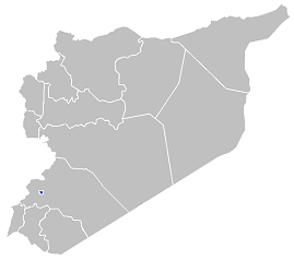
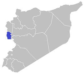
The Damascus Governorate
The Damascus Governorate is the capital of Syria and is the center of Metropolitan Damascus.
The Damascus Governorate has an area of 105 sq. km (41 sq. miles) and had, at the end of 2011, a population of 1,754,000 - a population density of 16,705 people per sq. km.
Metropolitan Damascus is very densely populated and at the end of 2011 had a population of about 3,500,000. There are some estimates that put the real total population of Metropolitan Damascus at up to 5,000,000.
Hundreds of thousands of (possibly more than a million) Palestinian and Iraqi refugees live in Metropolitan Damascus.
Damascus is Syria’s second largest city, after Aleppo. However, Metropolitan Damascus is larger than Aleppo.
- - - - - - - - - - - - - - - - - - - - -
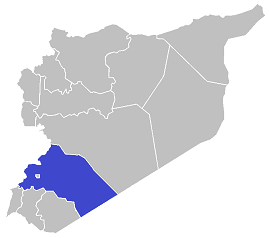
The Rif Dimashq Governorate
The Rif Dimashq Governorate surrounds the Damascus Governorate, has an area of 18,035 sq. km (6,963 sq. miles) and had, at the end of 2011, a population of 2,836,000 - a population density of 157 people per sq. km.
35% of its population lives in rural areas and 65% in urban areas.
Its administration is located in the Damascus Governorate.
Essentially all of the population of the Rif Dimashq Governorate lives in or near Metropolitan Damascus in an area which is about 10% of the governorate’s total area. The other 90% of the governorate is empty barren desert, volcanic fields or lava fields.
The Ghouta Oasis, which is east and south of Damascus, is the governorate's greenest area, and is historically the reason Damascus was able to become one of the Middle East’s major cities.
- - - - - - - - - - - - - - - - - - - - -
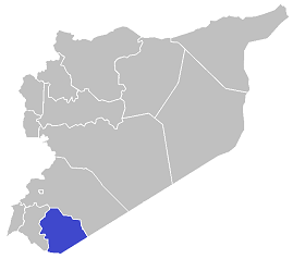
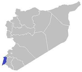
The As-Suwayda Governorate
The As-Suwayda Governorate has an area of 5,550 sq. km (2,143 sq. miles) and had, at the end of 2011, a population of 370,000 - a population density of 67 people per sq. km.
The As-Suwayda Governorate has a Druze majority.
61% of its population lives in rural areas and 39% in urban areas.
Its capital, also named As-Suwayda, had an estimated population of about 86,000 at the end of 2011.
Essentially all of the population of the As-Suwayda Governorate lives in the western and southwestern 40% of the governorate. The remaining 60% (the northern and eastern areas) of the governorate is barren empty desert.
- - - - - - - - - - - - - - - - - - - - -
The Daraa Governorate
The Daraa Governorate has an area of 3,730 sq. km (1,440 sq. miles) and had, at the end of 2011, a population of 1,027,000 - a population density of 275 people per sq. km.
55% of its population lives in rural areas and 45% in urban areas.
Its capital, also named Daraa, had an estimated population of about 118,000 at the end of 2011.
The Daraa Governorate is an important agricultural area and about 80% of its land is cultivated. The remaining 15-20% is barren empty lava fields or desert.
The Damascus-Amman Highway goes through the middle of the governorate.
- - - - - - - - - - - - - - - - - - - - -
The Quneitra Governorate
The Quneitra Governorate has an area of 1,860 sq. km (718 sq. miles) and had, at the end of 2011, a population of 90,000 - a population density of 48 people per sq. km.
All of its population lives in rural areas.
70% of the Quneitra Governorate (1,295 sq. km according to the US Government) is occupied by Israel. About 22,000 Syrians, mostly Druze, still live in this occupied area, and about 22,000 Israeli citizens also live there in 30 Israeli settlements.
The UNDOF Area of Separation, which was established in 1974, takes up another 12.5% (235 sq. km) of the Quneitra Governorate. The UNDOF Area of Separation is inhabited by Syrians and governed and policed by Syrian authorities, but no military forces other than UNDOF are permitted within it.
The Quneitra Governorate’s nominal capital, also named Quneitra, had an estimated population of about 200 at the end of 2011. The capital was largely destroyed by the Israelis - along with most of the other towns and villages in the occupied area - in 1974.
Almost all of the area of the governorate which is not occupied by Israel is cultivated.
- - - - - - - - - - - - - - - - - - - - -
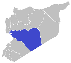
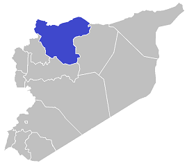
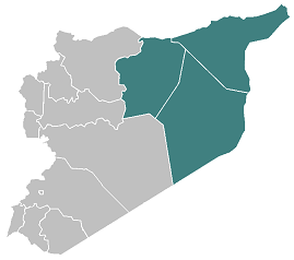
The population concentration
in northwestern Syria
In the Homs, Hama, Aleppo, Idlib, Latakia and Tartus Governorates
According to Syrian Government statistics 11,605,000 people, 54.3% of the population, lived in the northwestern corner of the country at the end of 2011.
Almost all the areas in the Idlib, Latakia and Tartus Governorates are inhabited, as is most of the Aleppo Governorate, the southwest corner of which is barren empty desert. About two-thirds of the Hama Governorate is inhabited and cultivated, but its eastern third is barren empty desert. Only the northwestern corner of the Homs Governorate is habited, and the remaining 90% is barren empty desert.
- - - - - - - - - - - - - - - - - - - - -
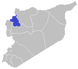
The Homs Governorate
The Homs Governorate, geographically the largest in Syria, has an area of 40,920 sq. km (15,799 sq. miles) and had, at the end of 2011, a population of 1,803,000 - a population density of 44 people per sq. km.
46% of its population lives in rural areas and 54% in urban areas.
Its capital, also named Homs, which is located near the Orontes River and Lake Qattinah, had an estimated population of about 762,000 at the end of 2011.
Essentially all of the population of the Homs Governorate lives in its fertile northwestern corner in or near the city of Homs. The remaining 90% of the governorate is barren empty desert.
- - - - - - - - - - - - - - - - - - - - -
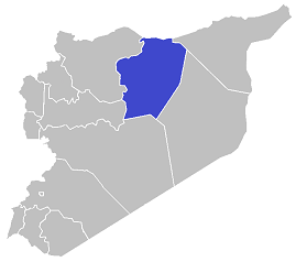
The Hama Governorate
The Hama Governorate has an area of 10,180 sq. km (3,931 sq. miles) and had, at the end of 2011, a population of 1,628,000 - a population density of 160 people per sq. km.
63% of its population lives in rural areas and 37% in urban areas.
Its capital, also named Hama, which is located on the Orontes River, had an estimated population of about 364,000 at the end of 2011.
Most of the population of the Hama Governorate lives in the fertile western third of the governorate. The central third of the governorate is more arid but still cultivated, while the eastern third is barren empty desert.
- - - - - - - - - - - - - - - - - - - - -
The Aleppo Governorate
The Aleppo Governorate has an area of 18,500 sq. km (7,143 sq. miles) and had, at the end of 2011, a population of 4,868,000 - a population density of 263 people per sq. km.
The Aleppo Governorate is the most populous governorate in Syria, and Aleppo is Syria’s largest city and second largest metropolitan area, after Metropolitan Damascus.
36% of its population lives in rural areas and 62% in urban areas.
Its capital, also named Aleppo, had an estimated population of about 2,552,000 at the end of 2011.
More than 50% of the land in the Aleppo Governorate is cultivated, but the areas in the west of the governorate are more arid and less productive. Its northwest corner is highlands, and the southern 15% of the governorate’s area is barren empty desert.
- - - - - - - - - - - - - - - - - - - - -
The Idlib Governorate
The Idlib Governorate has an area of 6,100 sq. km (2,355 sq. miles) and had, at the end of 2011, a population of 1,501,000 - a population density of 246 people per sq. km.
71% of its population lives in rural areas and 29% in urban areas.
Its capital, also named Idlib, had an estimated population of about 117,000 at the end of 2011.
Almost all of the land in the Idlib Governorate is cultivated. A small area in its northwest is highlands and the climate in its southeastern areas is more arid.
- - - - - - - - - - - - - - - - - - - - -
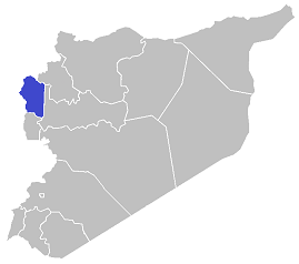
The Latakia Governorate
The Latakia Governorate has an area of 2,300 sq. km (888 sq. miles) and had, at the end of 2011, a population of 1,008,000 - a population density of 438 people per sq. km.
The Latakia Governorate has a Alawite majority.
49% of its population lives in rural areas and 51% in urban areas.
Its capital, also named Latakia, is the principal port city of Syria and had an estimated population of about 438,000 at the end of 2011.
The Latakia Governorate enjoys good rainfall and is very green but is also rugged and mountainous which limits agriculture to some degree.
- - - - - - - - - - - - - - - - - - - - -
The Tartus Governorate
The Tartus Governorate has an area of 1,900 sq. km (734 sq. miles) and had, at the end of 2011, a population of 797,000 - a population density of 419 people per sq. km.
The Tartus Governorate has a Alawite majority.
71% of its population lives in rural areas and 29% in urban areas.
Its capital, also named Tartus, is the second largest port city in Syria and had an estimated population of about 129,000 at the end of 2011.
The Tartus Governorate enjoys good rainfall and is very green but is also rugged and mountainous in which limits agriculture to some degree.
- - - - - - - - - - - - - - - - - - - - -
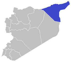
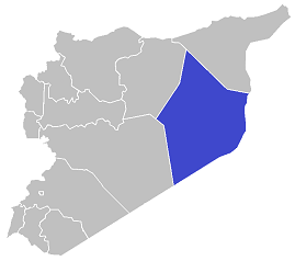
The population concentration
in northeastern Syria
In the Ar-Raqqah, Al-Hasakah
and Deir ez-Zor Governorates
According to Syrian Government statistics 3,695,000 people, 17.3% of the population, lived in the northeastern corner of the country at the end of 2011.
This is Syria’s most sparsely populated area. While most of the Al-Hasakah Governorate and two-thirds of the Ar-Raqqah Governorate are inhabited and cultivated, only about 10% of the Deir ez-Zor Governorate is.
- - - - - - - - - - - - - - - - - - - - -
The Ar-Raqqah Governorate
The Ar-Raqqah Governorate has an area of 19,610 sq. km (7,571 sq. miles) and had, at the end of 2011, a population of 944,000 - a population density of 48 people per sq. km.
61% of its population lives in rural areas and 39% in urban areas.
Its capital, also named Ar-Raqqah, which is located where the Balikh River joins the Euphrates, had an estimated population of about 262,000 at the end of 2011.
In the Ar-Raqqah Governorate narrow strips of land along the banks of the Euphrates and of the Balikh River, a perennial river which originates at a spring just south of the Turkish-Syrian border and then flows southward until it joins the Euphrates, are heavily cultivated. The remainder of the area north of the Euphrates in the governorate is more lightly cultivated due to the low amount of annual rainfall it receives. Most of the area in the governorate south of the Euphrates, about a third of its total area, is empty barren desert.
- - - - - - - - - - - - - - - - - - - - -
The Al-Hasakah Governorate
The Al-Hasakah Governorate has an area of 23,330 sq. km (9,008 sq. miles) and had, at the end of 2011, a population of 1,512,000 - a population density of 65 people per sq. km.
The Kurds are probably in the majority in the Al-Hasakah Governorate, which also has a significant number of Assyrians and Chaldians.
64% of its population lives in rural areas and 36% in urban areas.
Its capital, also named Al-Hasakah, which is located on the Khabur River, had an estimated population of about 249,000 at the end of 2011.
The governorate’s other major city, Qamishli, which is located just south of the Turkish-Syrian border and is considered to be the unofficial capital of the Kurdish people in Syria, had an estimated population of about 244,000 at the end of 2011.
The Khabur River is a perennial river which flows from north to south through the governorate, and the Tigris forms the short northeastern border of the governorate and of Syria.
Oil and natural gas are produced in the Al-Hasakah Governorate, and most of its land is cultivated, but the southern half of the governorate is more arid than the northern half.
- - - - - - - - - - - - - - - - - - - - -
The Deir ez-Zor Governorate
The Deir ez-Zor Governorate has an area of 33,060 sq. km (12,765 sq. miles) and had, at the end of 2011, a population of 1,239,000 - a population density of 37 people per sq. km.
The Deir ez-Zor Governorate is predominately Sunni Arab, but the governorate has a significant number of Armenians.
55% of its population lives in rural areas and 45% in urban areas.
Its capital, also named Deir ez-Zor, which is located on the Euphrates, had an estimated population of about 256,000 at the end of 2011.
The Deir ez-Zor Governorate is the major oil and natural gas producing governorate in Syria.
In the Deir ez-Zor Governorate narrow strips of land along the banks of the Euphrates and of the Khabur River, a perennial river which flows south from the Al-Hasakah Governorate until it joins the Euphrates, are heavily cultivated. A small area in the north of the governorate is lightly cultivated due to the low amount of annual rainfall it receives. All of the remaining area in the governorate, about 90% of its total area, is empty barren desert.
- * - * - * - * - * -
- · The Largest Cities in Syria and Their Estimated Populations at the End of 2011 · -
Metropolitan Damascus* 3,500,000
Aleppo 2,552,000
Homs 762,000
Latakia 438,000
Hamah 364,000
Ar-Raqqah 262,000
Deir ez-Zor 256,000
Al-Hasakah 249,000
Qamishli 244,000
Daraa 118,000
Idlib 117,000
Tartus 129,000
As-Suwayda 86,000
* Damascus had a population of 1,754,000 at the end of 2011.
- * - * - * - * - * -
- · Syria’s Economy and Basic Economic Indicators · -
Syria’s economy grew reasonably well between 2000 and 2010. However, Syria’s large population and population growth, the large number of Iraqis (more than 1.5 million) who fled to Syria during this period, a severe drought from 2006-2010, and controversial economic reforms implemented at the behest of the EU all had negative effects.
At the end of 2010, Syria’s Total Government Gross Debt was 27.459% of GDP, about $16.24 billion, and Syria had total reserves of $20,631,905,972.62.
The life expectancy at birth in Syria rose from 74 years in 2000 to 76 years in 2010.
Syria’s Total Government Net Borrowing
as a % of GDP 2000-2011 (- Deficit / + Surplus)
2000 -1.361
2001 +2.305
2002 -2.023
2003 -2.704
2004 -4.182
2005 -4.408
2006 -1.098
2007 -3.977
2008 -2.868
2009 -2.897
2010 -4.821
2011 -6.804
Annual GDP Growth in Syria 2000-2011 (2011 estimated)
2000 2.7%
2001 5.2%
2002 5.9%
2003 0.6%
2004 6.9%
2005 6.2%
2006 5.0%
2007 5.7%
2008 4.5%
2009 6.0%
2010 3.2%
2011 -2.0%
Syria’s GDP in Current USD 2000-2010
2000 19,325,894,913
2001 21,099,833,784
2002 21,582,248,882
2003 21,828,144,686
2004 25,086,930,693
2005 28,858,965,517
2006 33,332,844,575
2007 40,405,006,007
2008 52,581,913,978
2009 53,934,534,351
2010 59,147,033,452
Syria’s GDP per Capita in Current USD 2000-2010
2000 1,209
2001 1,282
2002 1,272
2003 1,248
2004 1,393
2005 1,561
2006 1,767
2007 2,099
2008 2,678
2009 2,692
2010 2,893
Syria’s GNI per Capita, PPP in Current International $ 2000-2010
2000 3,180
2001 3,350
2002 3,480
2003 3,480
2004 3,750
2005 4,010
2006 4,270
2007 4,600
2008 4,790
2009 5,040
2010 5,090
Syria’s Annual Population Growth Rate 2000-2011
2000 2.67%
2001 2.92%
2002 3.09%
2003 3.11%
2004 2.94%
2005 2.66%
2006 2.04%
2007 2.04%
2008 2.04%
2009 2.04%
2010 2.04%
2011 1.81%
- * - * - * - * - * -