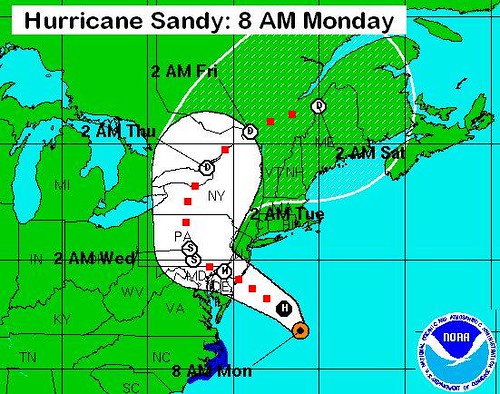
Sandy tracked around to West-By-North-West 280-degrees.
Then 50 miles out, Sandy turned north to NNW 330-degrees and came ashore just south of Atlantic City.
This turn is sharper than what was anticipated 16-hours ago. The storm is moving at 28 mph with winds of 90 mph. If the current direction does not go further west, landfall is projected for Cape May, New Jersey.
This is 65 miles south on the coastline from the midline predictions yesterday evening. Track line has moved from NWN 330 to WNW 280 in the last 5 hours.
It is was still going along at 28 mph. Here's the old track line from this morning.
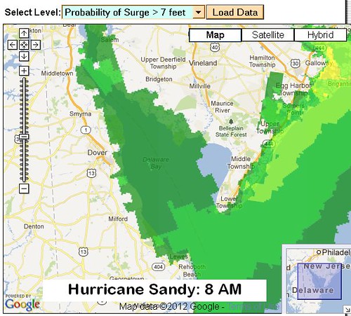
Storm surge projections at NOAA indicate they have been updated as of 11 AM using the data from NOAA's main 8 AM cycle. These maps do not reflect this new 4 PM info that the track line has rotated to the Cape May line.
Keep close watch on these charts, particularly if you are near Delaware Bay or up Delaware river.
Early on a smallish 5% "cone" probability was assigned to the eye going all the way south, directly into the Delaware Bay. That event now depends only on seeing another 10 miles of southerly "kink" to the tracking line.
This would bring the main force "eye" wall of water right into the Bay.
This situation is the worst case for residents on Delaware Bay and Delaware River. All of a sudden their shore would get hit with storm surge similar to the barrier islands on the Jersey Shore.
Main force risk applies to southern New Jersey, Delaware, Maryland and southern Pennsylvania. Text from the NOAA 4 PM Update, the Delaware Bay situation, and links below le chignon d'orange....
ALL OF THE FOLLOWING TEXT IS OUTDATED.
SANDY KINKED NORTH. HIT JUST SOUTH 0F ATLANTIC CITY.
LIGHT ON DEATHS, HEAVY ON PROPERTY DAMAGE IN $50-BB RANGE.
Landfall for the eye is now tracking just up the coast from Cape May.
National Hurricane Center
Anyone near Delaware Bay should now consider themselves in the bulls eye.
If and if... the landfall moves the eye another 10 miles south that puts it right through Delaware Bay. The "cone" for track line probabilities assigned no more than 5% to that possibility as of last night.
Stranger things have happened.
With the eye pushing its wall of water ahead of the track line, a major storm surge would then be rammed right into the Bay and up the Delaware River.
Here is a surge map based on a still-northerly track line. That will be updated during the day. Don't be surprised to see a 12-hour delay between track line changes and surge map changes.
If the track line takes the southerly 5% route and shifts to put the eye directly into the Delaware Bay, then everything changes for that region.
A main force surge into the Bay and up the Delaware River would look like the projections for the barrier islands.
Probabilities ??? No way to know, other than to rely on the "cone" map and its attempt to apply historical statistical patterns. (Here, for Sandy, there's no history. No similar storm in the records. So the earlier "5%" rating was a guesstimate when it came out.)
The observed overnight change that moved the track line to the south away from New York City and toward Cape May is similar to a 50-mile southward "kink" that Andrew took just before hitting Florida in 1992. Instead of utterly wrecking Miami Beach and Miami, Andrew chose instead to obliterate Homestead.
"Obliterate" as in "gone." Such is the innate perversity of inanimate objects.
Andrew came in with 922 millibar pressure, very high velocity winds, ordinary point-by-point duration, and he caused $26-billion damage. Sandy is P.O.'d that she can only muster 940 millibars as of this morning. (#17 was Rafael, #16 was Patty. She's a she.)
She is also livid that the Presidential Debates ignored her god of creation, who be'eth Climate Change.
Hurricanes are alive. Despite being inanimate.
Trade off high winds for very long point-by-point duration and Sandy is starting to look more and more like Andrew. Expect a near record-breaking release of destructive energies.
The National Hurricane Center web site, for its part, is relatively easy to use for info:
-- On the main page, titled Hurricane Sandy, scroll down half-way.
-- You will see a dozen icons, mostly map thumbnails.
-- Warnings/Cone Static Images -- simple storm tracking
-- Storm Surge Probabilities and the Exceedance -- massive coastal flooding
Here's the warning from 8 AM, as presented with the 11 AM Update info that showed higher winds and lower air pressure:
BULLETIN
HURRICANE SANDY ADVISORY NUMBER 29
NWS NATIONAL HURRICANE CENTER MIAMI FL
0400 PM EDT MON OCT 29 2012
...SANDY MOVING MORE QUICKLY TOWARD CAPE MAY NEW JERSEY...
...LANDFALL EXPECTED EARLY THIS EVENING...
(And earlier -- still true:
...EXPECTED TO BRING LIFE-THREATENING STORM SURGE AND COASTAL HURRICANE WINDS PLUS HEAVY APPALACHIAN SNOWS...)
Location: 38.6°N 74.0°W
-- ABOUT 50 MI...SSE OF ATLANTIC CITY NEW JERSEY
-- MAXIMUM SUSTAINED WINDS...90 MPH...
-- PRESENT MOVEMENT...280 DEGREES AT 28 MPH...
MINIMUM CENTRAL PRESSURE...940 MB...27.76 INCHES
Track direction has westerlied significantly overnight and now sits at 280-degrees.
THIS LOOKS TO MOVE DELAWARE BAY INTO PLAY.
We need a "cone" update.
The earlier expectations at NOAA had landfall as late as 6 AM tomorrow. No way. 0630 PM is more like it.
Cooling off with water temperatures falling from 79-degrees F. in the Gulf Stream to the 70s and then 60 F. at the coast will have minimum impact on Sandy's energy content.
Don't be too angry at the modellers - they've never ever had to deal with a storm like this one.
The 940 millibar surface air pressure should scare anybody in harm's way. That is very powerful. Don't be fooled by wind speeds -- duration matters and the water yield from Sandy will have to be measured when we have her ashore.
Sandy is set up now to deliver across an 800-mile storm front and do it over as much as a World Record point-by-point 40-hour duration.
The good news, such as it is, is that the "loop back" scenarios have faded from the models.
Those possibilities had Sandy going ashore, moving into Pennsylvania, then turning south (!) and sitting over West Virginia and Maryland for the better part of a day. Soil would have reached saturation, followed by trees being shaken far beyond their natural limits. Not one house in ten is built to withstand such wind forces and such amounts of water over such a time period without sustaining structural damage.
Sandy is projected now to plow on into Pennsylvania for a couple hundred miles, then turn right to points north. (Go Canada!)
That "loop back" result could have produced Katrina-scale destruction for a swath of Maryland and southern Pennsylvania and West Virginia. The point-by-point energy release would have been similar in effect to a super-size Cat I tornado with inland flooding.
Storm surge problems for New York City are difficult to project. We are seeing 50:50 probabilities all along the cost for 9-foot and 11-foot surges with 20-foot waves on top of the surges. If Sandy does track to further to the south, that has to take some of the pressure off NYC. But not by much as this is an 800-mile wide storm. A 50-mile change along the center of the storm front ain't much of a difference for generating storm surge.
The 100 miles of barrier islands at the Jersey Shore -- fergitaboutit!
Waves are generated by a combination of wind speed and oceanic straight-line push. These waves on the frontal northeast quadrant of 800-mile-wide Sandy will be hitting the barrier islands with surges, plus waves that can easily max out at twice the height of the current 12- to 24-foot oceanic averages.
As the Samuel-Man says in his Obama commercial: "Wake the f*ck up !!"
Get out of there if you are anywhere to the north along the Jersey or Long Island or Connecticut coastlines or in line even 100 miles ashore for a main force visit from Sandy. Go read up on Andrew if you want a preview to what is likely to happen this evening and Tuesday morning.
God bless all of you and on the eastern seaboard -- Lord knows anybody near the Delaware Bay -- good luck !
