UPDATES:
New Jersey Department of Environmental Protection spokesman Larry Hajna said “there doesn’t appear to be any immediate, imminent threat” to the area’s water.
-source
After exposure to vinyl chloride gas, dozens of people went to ER rooms for first aid. On the train that crashed, the chemical was being transported as a pressurized liquid. When the container broke, some of the chemical reverted to its gas state and some undoubtedly contaminated the water.
Authorities said that Mantua Creek was boomed this morning so tidal waters would not stir up contaminated sediment. IMO, this indicates that vinyl chloride, a known carcinogen, is likely in the water.
SUMMARY:
The Philadelphia Water Department has a computer model that can calculate if a major source of Philadelphia's drinking water (the Baxter Water Treatment Plant) is in eminent danger of contamination from today's vinyl chloride spill.
In November of 2004, there was an oil spill in Paulsboro, which is also the site of the current train crash and spill of vinyl chloride. That oil got within 3 miles of the intake point for drinking water, meaning the oil was able to travel upstream with tidal flows for over 15 miles.
Is vinyl chloride going to contaminate Philly's drinking water? At dangerous levels? Can a release of water from reservoirs help protect this source of drinking water?
--- --- ---
Background Information:
The Baxter Water Treatment Plant treats an average of 200 million gallons a day...Baxter provides water to almost 60% of the City's population. It also serves some parts of Lower Bucks County.
- City of Philadelphia
The Baxter Water Treatment Plant is located in the tidal zone of the Delaware River and can therefore be affected by contaminants moving north to south with the river flow and south to north with the tidal waters.
Source: Pennsylvania Department of Environmental Protection, "Delaware River Watershed Source Water Protection Plan (PWD Baxter Intake – PWSID# 1510001)". 2007. PDF
(continued below)
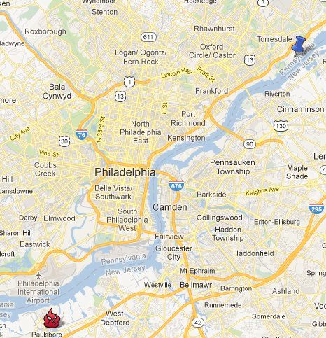
Here's a map showing the location of the leak and the general location of the drinking water intake. The water intake location is about 20 miles up the Delaware River from the Mantua Creek.
The other two water treatment plants for Philly (the Belmont and the Queen Lane) are not at risk because they are located on the Schuylkill River above the Fairmount Dam, which is the uppermost tidal limit of the Schuylkill River (source PDF).
The people in charge of protecting Philadelphia's drinking water are most likely responding to this problem right now:
The Philadelphia Water Department has developed a time-of-travel model that can be
used to calculate the amount of time it would take a contaminant to flow towards the
Baxter Water Treatment Plant. This model can be used for emergency response
preparations as well as actual events.
Two prominent threats are the rupture of a buried underground pipeline and a spill
within the tidal zone near the Baxter Water Treatment Plant.
[snip]
previous accidents, such as the Athos I spill, can be used to improve emergency response in the unfortunate occasion of another spill or contamination event.
[snip]
On November 26, 2004 around nine o’clock at night, the 750 foot single-hulled Athos I
oil tanker was punctured while attempting to dock at the CITGO asphalt refinery in
Paulsboro, New Jersey.
[snip]
The Baxter intake did not have to close during the Athos I spill, but the situation was
closely monitored. The spill model was used to accurately predict the upstream extent of
the oil spill. The oil spill occurred on the southern border of the Zone A source water
area delineation at Paulsboro, New Jersey and spread to locations within Zone A. Of
serious concern was the northern reach of the spill near the Tacony-Palmyra Bridge that
came within three miles of the Baxter intake. Although oil never reached the intake and
a majority of the oil spilled was recovered, oil that has settled onto river bed sediments
can be dislodged and circulated during storm events posing a current threat.
Source: Pennsylvania Department of Environmental Protection, "Delaware River Watershed Source Water Protection Plan (PWD Baxter Intake – PWSID# 1510001)". 2007. PDF
I have no idea if water releases from reservoirs can help the situation, but it might be a good question to ask the authorities. If they aren't sure, then perhaps a precautionary release of water may be a good idea.
Water releases from five reservoirs are used to help repel, or flush back, the salt-laced water. Three reservoirs -- Pepacton, Neversink and Cannonsville -- are owned by New York City and are located in the Delaware River's headwaters in the Catskill Mountains in New York State. When full, these three reservoirs hold 271 billion gallons of water. Two additional reservoirs -- Blue Marsh and Beltzville -- are located in Pennsylvania along the Schuylkill River in Berks County and the Lehigh River in Carbon County, respectively. These two lower basin reservoirs hold nearly 20 billion gallons of water when full.
- Delaware River Basin Commission
Also, during this morning's press conference authorities reported that the Mantua Creek was boomed in order to keep tidal waters from stirring up any contaminated sediment at the site of the train crash...
