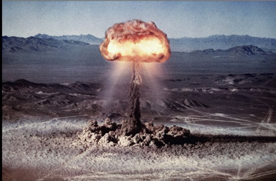
In this continuing armchair virtual tour series, and thanks to the community for being so receptive to same, we’re headed back to the desert country, this time in the Moab, Utah vicinity. Canyonlands is second to no other canyon in the world, and as the name implies, it is a series of canyons in the context of a greater mother canyon. Indeed, its province is separated into three huge parcels. This tour will introduce to each sector, as well as discuss many of this national park’s facets: geology, natural and human history, but this time more background will be provided. The reason is because Canyonlands may be the most ideal terrain to learn about peripheral subject matter, such as desert ecology, salt (of all things), and a fascinating human history starting with the Ancestral Puebloans and extending to the Mormons and cowboys of the 19th and 20th centuries, and uranium miners in the 1950s. In fact, Atomic City (a/k/a Los Alamos, New Mexico) could not have functioned without its post World War II life had it not been for the uranium boom in this part of Utah’s Great Basin Desert.
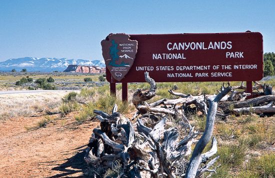
Location/Geography: In south central Utah, San Juan, Wayne, Garfield and Grand Counties. Closest city: Moab. Area: 337,570 acres (527 square miles/1,366 sq. km).
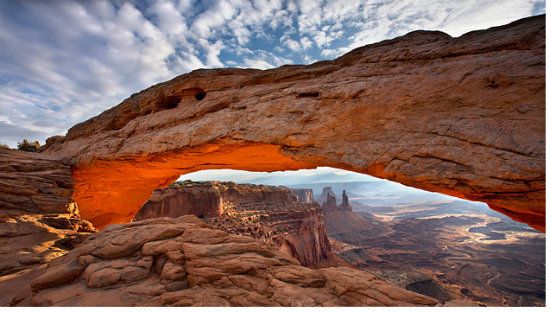
Spotlight: The first of the great canyons inscribed by the Colorado River, where it merges with the Green River above Moab. A spectacular sandstone maze of mini canyons featuring three distinct districts.
(Continues after the fold.)
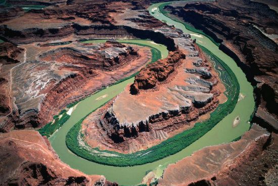
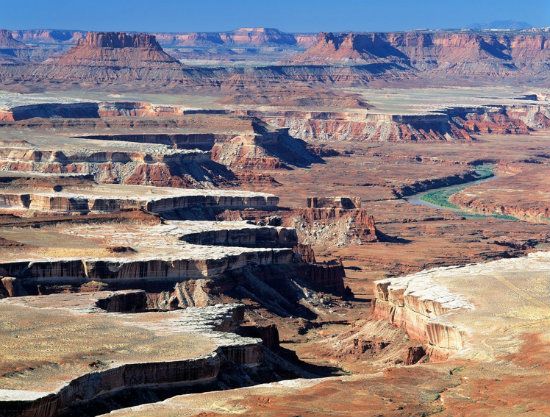
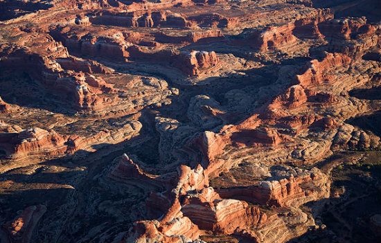
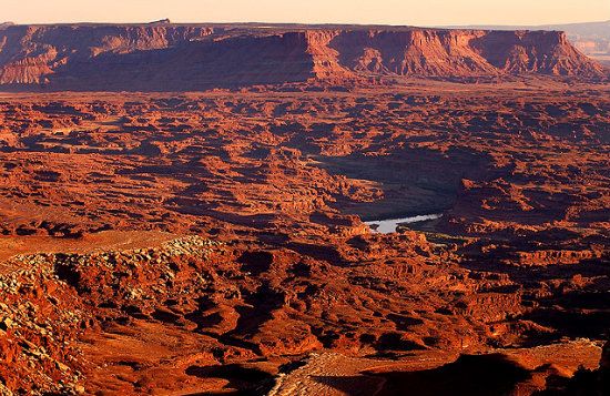
Snapshot: Canyonlands is a sprawling landscape of sedimentary rock located in the heart of the Colorado Plateau. From the raven's perspective, it is a convoluted landscape dissected by the Colorado and Green rivers, where both sibling drainages merge.
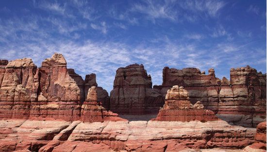
When it was designated a national park status in 1964, relatively few people were even familiar with this remote multi-chasm terrain spread out below the backdrop of the La Sal Mountains. For a time, prehistoric people had managed to sustain a fragile existence in an equally fragile environment. Still, the sparsity of their numbers says what it does about the hardships of settlement in this locale, especially relegated to poor farming conditions. To a large degree, Canyonlands remains untrammeled today. Its minimal network of roads access only a few areas of the park (mainly part of the Island in the Sky and the Needles, which are two of three major districts dividing the park’s vast holdings). However, trails remain primitive to backcountry (though there is some decent day hiking trails here and there). Water and gravity are the prime architects that have fashioned the mesas, buttes, arches and pinnacles throughout this mostly backcountry domain. Time and erosion have also done wonders in hewing an array of landscape features. Nearly all the rocks are pinkish in color, brick red or salmon in some places; also, tinted with varying amounts of the mineral hematite. Patina (a/k/a "desert varnish") stains some of the broader surfaces with telltale blue-black streaks. Sometimes these artistic designs on rock facades border on the exotic. Canyonlands takes its name from hundreds of lesser canyons with the same geological features and setting seen more abundantly here. Indeed, here is nature's greatest gift in the guise of a broad landscape accented by scrimshaw-carved canyons.
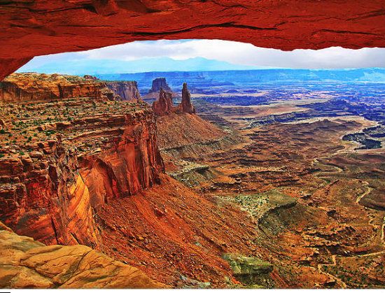
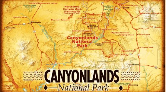
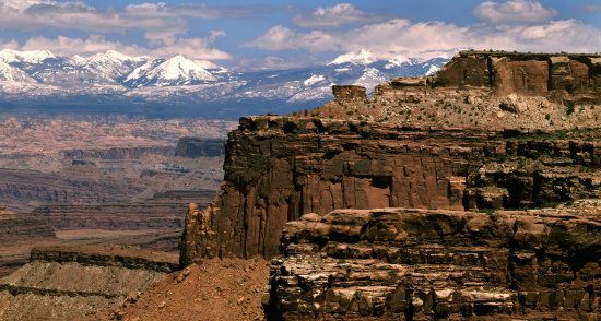
Guided Tour Essentials: Canyonlands oversees three regions initially incised by the Green and Colorado rivers flowing hundreds of feet below the high rims: the Maze, Island in the Sky, and Needles districts. To the north, the Island in the Sky district overlooks the canyon country from a lofty mesa top 1,000 to 2,000 feet above the surrounding terrain. Bordered by the Green River on the west and the Colorado River on the east, this facet of the park boasts the most spectacular views of tributary canyons and geologic formations. Maze-like in every respect, there is an unpaved road through this sector, though recommended only for four-wheel drive.
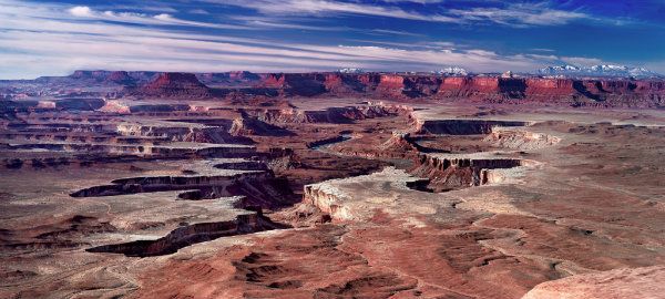
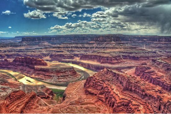
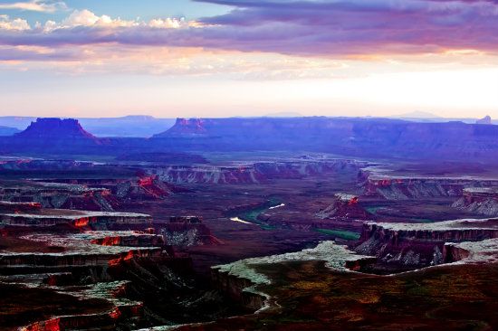
Neighboring Dead Horse Point also offers an exceptional and higher view of the confluence.
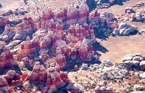
Across the Colorado, the Maze district is the least accessible. The Orange Cliffs Unit of the Glen Canyon National Recreation Area shares the western boundary of the park. Sometimes referred to as a thirty square mile puzzle inscribed in sandstone, this apt description of this district’s landscape says it all. The Maze is also known for its extreme backcountry terrain, where landforms and the layout of its geography is nothing less than dazzling and bizarre. With its fourteen amazing arches (thus far, this is the count), the Maze Overlook, the Golden Stairs, the ornate and convoluted Land of Standing Rock (a/k/a/ the Doll House), and The Chocolate Drops (trail), to mention just some, a trip into the Maze guarantees a superlative, rugged adventure in every sense. Indeed, visitors who venture here are also 100 miles (160 km) from anywhere. Still, the scenery and solitude is worth the risk for those who are in good physical shape. It should also be noted that four-wheel drive is required on vehicles. Likewise, the punishing drive to get to the Maze is often called the most strenuous part of the visit. The Wall, Standing Rock, and Chimney Rock Camps are not a drive for the faint-hearted nor recommended for street vehicles and drivers who think they can handle the terrain with back-road experience.
The seeming indescribable pinkish and white Doll House (just so you know what its terrain really looks like):
Completing the trinity of Canyonlands is the Needles district. Aptly named for its colorful spires and fins of sandstone, this popular facet of the park is also the most visited sector (mainly because it is more accessible than the Island In The Sky, and especially the bone-jarring and jaw-loosening entry into the Maze district. (There is no hyperbole given this description.) Moreover, the Needles is suited for passenger vehicles and buses.
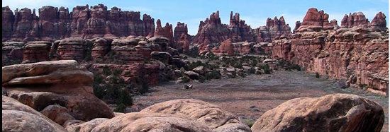
From a more distant perspective, a Martian-like landscape, I think:

Situated in the southeast corner of the park, this district has another advantage over the other two facets: it’s the most popular backpacking destination in the entire region (and that's really saying something). In select places, the Needles sector doubles as another popular four-wheel drive challenge: Angel Arch, Elephant Hill, Confluence Overlook, and Chesler Park are some of the most popular attractions in this outback, and usually bone-jarring, trip in any vehicle. There’s also another facet to Canyonlands, though not a district in the same league as the other three: Horseshoe Canyon. Annexed in 1971, this equally scenic attraction is now a detached unit of the park. Famous for its rock art and home to prehistoric Indians for hundreds of years, this sector eventually became home to European settlers, sheep and cattle ranchers, even outlaws. In the mid-20th Century, oil and uranium prospectors came here by the hoards. Then again, look how huge this estate was and it was all for the taking, that is, until the Department of the Interior stepped in and said, "Take nothing but pictures; leave on footprints." Thus a Leave No Trace policy that has been with us ever since.
Notably, each aspect of the park shares a common and primitive atmosphere, thereby preserving a desert environment as diverse in its flora and fauna as the canyon topography is craggy, maze-like and utterly contrasting. Each district, plus the annexed Horseshoe Canyon, offers its own special rewards. Throughout this protected turf roam the Great Basin Desert's iconic predators, avians, reptiles and smaller mammals (see below), all of which keep Canyonlands feral and free.
Geology: Advancing and retreating seas and oceans each left thick deposits of beach sands and marine limestones. Various river and stream systems moved tons of additional sediment from such eroding mountain ranges as the Ancestral Rocky Mountains (a/k/a the "Uncompahgre Highlands"), which preceded today's second Rocky Mountain province. The accumulated and additional sediments were deposited in low-lying areas. This storehouse and foundation material would eventually serve as the setting for Canyonlands geography and inscribed topographical features. When the Colorado Plateau was elevated (starting about 66 million years ago), the Four Corners region became primed for erosion and downcutting by streams and rivers. Under enormous heat and pressure, buried sediment turned into solid rock. Overlying layers and percolating water through the permeable sandstone and limestone cemented the various and distinct layers below. Thanks to the perseverance of the Colorado and Green River architects, these fluid waterways, the two principals of the Colorado Plateau, carved deep canyons over 2,000 feet, making this region a veritable landscape of canyons within the context of the greater mother canyon. (See “Geology Layers” below for a continuation of Canyonlands specific geologic blueprints.)
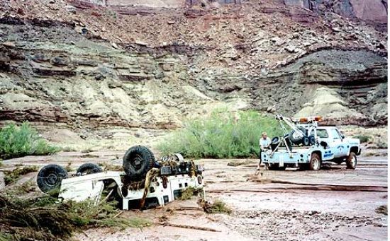
The Power Of Water: Thousands of smaller canyon fissures represent a common site here, all initially cut by water and fashioned by erosion. Canyonlands sparsity of vegetation also abets the process. The barren soil and a plethora of exposed cliff and mantle-rock facades is what ultimately makes this landscape highly vulnerable to flash flooding. With little soil and vegetation to hold the water, runoff from powerful thunderstorms accelerates the erosion. The monsoon season (July to early September) might also be dubbed the speedy erosional wet season. During this typically stormy spell throughout the Southwest, arroyos and lesser washes explode from torrents of rushing water. The contour of canyons become tight, winding expressways for moving debris, including any living creature that happens to get caught in such forceful currents. The power of the water is also exponential as it funnels into the myriad canyon sectors. Erosive scouring caused by debris in the sediment-laden water is nothing less than formidable. This process during parts of the year is what deepens the canyon annexes and helps make each chasm a little wider each time flash floods occur. In this terrain, look for rushing red water and get the hell out of the way. . .it's more powerful than you think:

And don't you just love it. . .dunderhead types who think their Hummers are vehicles-almighty? Well, in flash floods it's water that's almighty. Never underestimate their awesome power. Of course, the tow truck driver won't underestimate the hefty cost of retrieving the vehicle!
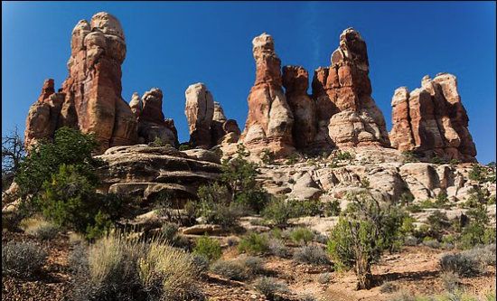
Scenic Marvels: Why and how do needles and spires form, and why are such geologic formations plentiful throughout sectors of the park? The unique architecture of Canyonlands is another form of erosion over the eons.
A few hundred million years ago this region suggested little more than a mundane appearance: a low-lying basin of immense proportion and partially open to the sea. (Remember: there were no mountain ranges to the west at this time, specifically the Sierra Nevada Range.) At times, the basin would fill with saline water. The usually arid climate would eventually evaporate the water until only salt remained––make that megatons––of salt that accumulated, congealed and compacted in many layers. Frequent cycles of flooding, evaporation, and salt deposition continued until a thick stratum of gypsum, halite (rock salt), sylvite (potassium chloride), and dolomite (a type of limestone) added to the foundational material. Combined, these materials created the lithified Paradox Formation, the dominant geologic bequeathment in this region. As additional rock layers were later deposited over these softer layers, pressure increased on the softer layers and liquified them. Eventually, as in nearby Arches National Park, the salts began to flow with the consistency of pliable putty. These flows vectored away from the areas of highest pressure, moving into areas of lowest pressure.
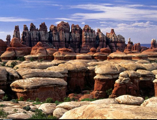
Stockpiled in huge masses, the salt material later pushed and squeezed its way upward, easily bending the overlying rock layers. For instance, in the Needles district parallel cracks formed as the overlying rock mantle slid toward the Colorado River on the relatively slippery salt below. The result, as seen from a high vantage point, would be a virtual checkerboard landscape with the appearance of a rumpled tablecloth, its usual tincture being burnt sienna. Rainwater and snow penetrated the weaker joints and thus the cracks widened over time. Erosion merely accelerated across an increasing area until its surface revealed thin fins and needles of rock remaining from the earlier non eroded layer. Hence, the geologic reasoning behind this suitably named sector of the park, the Needles. Moreover, soft rocks that might normally become sloped can morph into spires, that is as long as the rocks have a layer of erosion-resistant caprock on top.
Geology Specifics––Cliffs And How They Form: Most of the palisades throughout the park reveal a classic cliff profile. The uniform sandstone layers of (principally) Wingate and Cedar Mesa Sandstone are ideal for forming sheer facades. Gravity is equally an important partner in abetting the elements of erosion that continuously hone and refine Canyonlands profile. The effect of gravity causes softer underlying layers to erode more quickly than those harder layers above. This process (called "differential erosion") undercuts the harder upper layers, which then peel or break off, sometimes in huge slabs. The sandstone formations are quite ideal for arched alcoves. However, it's essentially the vertical-cliff profile that describes the overall layout of Canyonlands features; also the park's distinctive sloping facade adds to the landscape's appeal. Poorly cemented and softer layers of sand and shale (Organ Shale and the Chinle formations) are responsible for the noticeably askew appearance. Usually, their surfaces are covered with loose sediment, with fallen rock slabs from overlying cliffs mixed in with the crumbled material.
Geologic Layers: The rock footing of this sweeping territory of aesthetic contrasts gently arcs across the anticline of the broad Monument Uplift, which directly affects this region. As previously mentioned, for much of the Paleozoic Era (roughly, 541 to 251 million years ago) this region lay beneath a shallow sea, the water covering thousands of square miles/kilometers that resulted in the deposition of marine limestones, sandstone and shale. The subsiding basin was sometimes wet and sometimes dry. During the Pennsylvania Period (roughly, 321 to 299 million years ago) seawater was trapped in the basin, then eventually evaporated. Soon afterward the salt beds began to flow. This ongoing permutation feature of the region may have lasted until sometime in the Mesozoic Era (roughly, 251 to 66 million years), which we see in the dominant sedimentary layers of the park today. Of course, multilayered rocks were merely the basic and unadorned materials of a base foundation until the great uplift of the Colorado Plateau from which all else followed (possibly a two or three-pulsed uplifting period from (roughly) 71 to 41 million years ago).
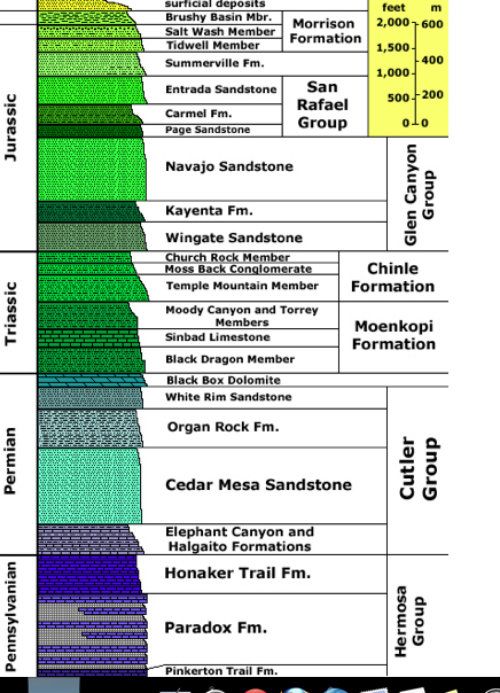
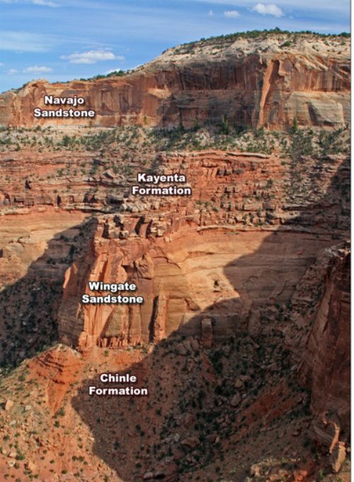
Besides the ubiquitous Wingate, Cutler Mesa, and Paradox formations, other prevalent rock strata throughout the park create a conspicuous layer cake profile, much like the distinct and numerous formations of the Grand Canyon, only not as colorful in Canyonlands. For instance, the gray-tinctured layer is the Honaker Trail Formation (a mixture of limestone, sandstone and shale), and the Halgaito Shale and Elephant Canyon formations (each created by coastal lowlands). These materials became part of a layering phase of varying sediments deposited over millions of years. Other materials also washed in, which added to the overall content. For instance, extensive alluvial fans that helped fill the basin, eventually mixing with the Uncompahgre Highlands and resulting in the iron-rich Cutler red beds (a/k/a/ "Arkose Sandstone"). Afterward, the underwater sandbars and blowing sand dunes mixed with the red beds, which accounts for the white-tinctured and cliff-forming Cedar Mesa Formation; also bright-colored oxidized muds later deposited to form the Organ Rock Shale. Another common formation in the park is the Moenkopi Sandstone. Its base materials came from vast flood plains and covered an equally ranging lowland, thereby burying the eroded surface with accumulated mud from tidal flats. Where Moenkopi rocks are found, the colorful and sterile-looking Chinle Formation also appears. Its blue and purple-colored formation blankets the eroded surface.
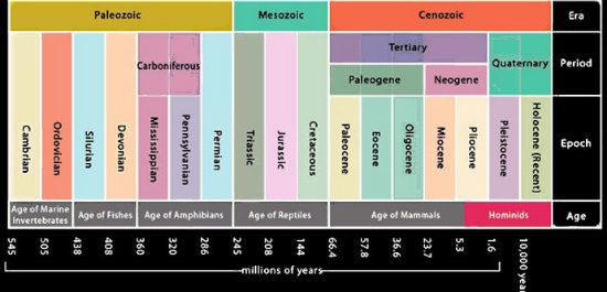
The alternating dry and wet climate naturally introduced various and different kinds of building materials. During the Mesozoic's Triassic Period (roughly, 251 to 201 million years ago), the climate became increasingly dry, resulting in more encroaching sand dunes that accumulated and shifted for hundreds of thousands of years. Later, when the sand compacted and congealed, their petrified remains were classified as the Wingate Sandstone Formation. The climate changed again, this time the Kayenta Formation monopolized geologic events. Its contribution to the layering effect was followed by yet another long stretch of aridity, so that much of western North America was again covered by a sweeping desert. Later, those desert sands created the materials for the cross-bedded Navajo Sandstone laid down on top of all the previously deposited rock layers. Mudflats followed and its material formed the Carmel Formation and Entrada Sandstone. From all the above description, the formula for Canyonlands layered appearance comes down to the obvious: different types of rock laid down over long periods and deposited in different layers. Once compacted and congealed, the uplifted terrain (the uplift of the Colorado Plateau) was primed for downcutting by the Green and Colorado rivers, among lesser regional streams. From the initial etchings into the back of the terrain, the elements of erosion then worked in concert with the combined downcutting-uplifting process. . .by which all has followed: Canyonlands noble and faceted features.
Bonus Details: By description, the Colorado Plateau's most characteristic feature is the land of flat-lying rocks. This means all the strata are laid down one at a time, the oldest stacked at the bottom. Compare this region to the Rocky Mountain province's vertical appearance. Thus, the literal uprising of mountains compared to the laying down of seas, swamps, deserts and other environments that accounts for the sedimentary deposition process of the Colorado Plateau.
Human History: Paleo-Indians first entered this region some 10,000 years ago. This estimate is a fairly common anthropological reference, though the date more than likely is much older. This designated benchmark comes from evidence of circular pits prehistoric people used for cooking. Since only humans use fire and create such designs, scientists rely on Carbon-14 methods, sometimes called radiocarbon dating. Carbon-14 is especially accurate when dating objects up to 40,000 years or younger (and by some estimates, 50,000 years is the limit).
Dendrochronology (tree-ring dating) is another accurate method to reference sites. By contrast, paleontologists delve into artifacts millions of years old. Thus, their benchmarks rely on other dating methods, such as radiometric comparisons between the observed abundance of a naturally occurring radioactive isotope and its decay products, using known decay rates. In short, radioactive parent elements decay to stable daughter elements.
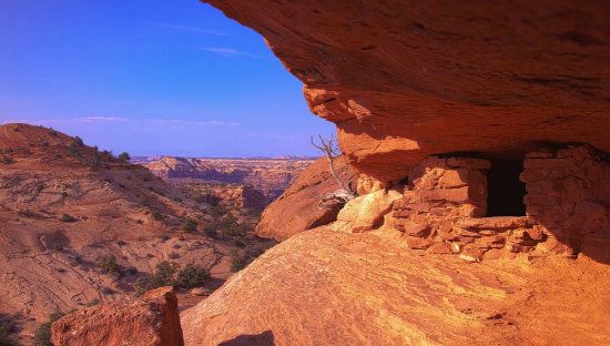
Since paleo times, there have been numerous tides of human occupation passing through this area, all of whom depended on the availability of natural resources, especially water. If the geologic setting is conducive to plant and animal life, it follows that humans can also manage a foothold and endure for as long as natural resources last, especially water. The first people known to inhabit the territory were Archaic Era hunter-gatherers. They were here between 2,000 to 10,000 years ago. Like all hunter-gatherers, they came in search of large game animals and edible plants. They were a migratory culture and tended to live wherever natural shelters provided a stopgap and temporary home. Once the game and edible plants diminished, they merely moved on to another region. Their migration was ongoing due to the continuing depletion of resources. Indeed, many archeological sites reveal that the original dwellers stayed in one region for about thirty years, then migrated elsewhere. This insight is mentioned, because the late comers, the Ancestors, though still prehistoric people, were also hunter-gatherers, yet with a proclivity to settle. This region, however, was not favorable for their settlement due to limited water resources and a genuine lack of soil in a predominant sandstone pavement country.
After the Common Era began prehistoric people of varying cultures tended to be more settled, particularly the Ancestral Puebloans. Agriculture was the key to settlement since they became farmers, grew corn, and constructed slab-lined cists for storing grains. The Basketmaker-agriculturist era was born. During this period, these people lived in and around present-day Canyonlands (albeit the majority lived farther south in places like the San Juan Basin country). They constructed pit-houses and made fine, utilitarian basketry. Around 451, a form of crude pottery emerged, and likely was something learned and traded from people who lived off the Colorado Plateau (the Hohokam and Mayans, most likely). Other practical innovations came as well. For instance, the bow and arrow and new construction techniques resulting in multi-roomed dwellings, and some with kivas. As for the Ancestral Puebloans who ventured into this region in the latter part of the 13th Century, it was a marginal existence at best. Because of this setting’s isolation from the main melting pot of Ancestors living far to the south, Canyonlands, as a frontier, may have been a dead-end to their culture; at least this speculation is noted during the mass diaspora of their culture from the Four Corners region (sometime during the late-13th Century). Even for protection, as in safety in numbers, or for the sake of preserving a cultural unity, once the message was received by all communities near or far, the people surrendered to a greater will of the once again united community that was summoned for imminent departure from the homeland (though without the Hopi and Acoma people joining the large group).
There were also some smaller communities that decided to stay behind, whose people likely chose living or hiding in their favored locations. Was the reason meant to escape of warfare, drought and famine to the south? It was difficult to get a foothold on the land and subsistence by agriculture was minimal at best, but what was on their minds that kept them here?
All that we really know is the majority of Ancestral Puebloans vanished off the Colorado Plateau, and forever. Well, the majority went elsewhere and changed names, though not the cultural legacy. So, and in a way, their doing so could be construed as a temporary hiatus until the people were later resettled in New Mexico, who then became the extended legacy under the name Puebloan. Wherever these people went or came from, they always left a message of their presence; intelligible and cryptic symbols inscribed on rocks over many centuries.
Meanwhile, the Colorado Plateau was mostly empty of people. Far to the south the Mimbres people, who previously had settled in parts of the Mogollon (pronounced mug-ee-own) Rim, managed to sustain their culture. As for others, it’s likely the Hopi and Acoma settlements became island civilizations in a greater ocean of geography that was not touched by human hands for possibly many decades (and by some estimates it is said this territory was not settled again for nearly one hundred years).
Eventually, new migrations of other tribal people, notably the Ute, Southern Paiute, and Shoshone ventured onto the Colorado Plateau, whose natural resources, by then, were nearly restored. Then came the latest historic people, the Navajo, who wandered into a revitalized region that developed a wetter climate, its natural resources thus recharged. However, the dates of these various immigrations to the Four Corners region are educated at best. It’s also thought that the Great Basin Culture (Utes, Shoshones and Southern Paiutes) was already in place long before the epic Great Drought began (sometime during the late 1300s). After 1301, and perhaps over a period of 100 to 125 years, the later tribal groups moved into the Four Corners region and stayed. The Navajo became the dominant culture, while most of the Puebloans lived near the Colorado Plateau country, mostly inhabiting parts of central and northern New Mexico.
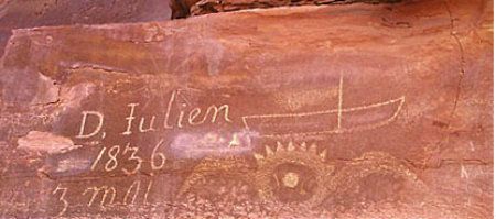
Other Notable Interlopers: When the acclaimed Franciscan padres, Escalante and Domínguez, started out on their 1776 expedition from Santa Fe, New Mexico they left with the hope of reaching present-day Monterey, California (which they failed to reach). Later, the U. S. Government was interested in acquiring this part of Utah from Spain (signing the Adams Onis treaty in 1819). Indeed, by the mid-19th Century politicians, assorted business owners, and similar enterprising people in the East were desirous of the Western territory, regardless who owned the land and lived here. (This great ambition began sometime during President Polk's term from 1845 to 1849). However, the covetous ownership policy did not deter mountain men from previously entering the future Canyonlands, whose vanguard of hardy men came to this territory earlier in the 1800s. From 1836 through 1838, an enigmatic trapper named Denis Julien left his moniker carved in sandstone faces throughout this region, including select canyons of the Colorado and Green River rivers.
Because settlers were coming to the West, many of whom were initially headed for the Northwest, the military was engaged in helping open the Western territory. The Army was also eager to know more about this region’s desert and canyon country. For instance, in 1859 Captain John N. Macomb was sent on an expedition to explore the Colorado Plateau (and many others like him followed), ostensibly to search for a wagon route from the New Mexico territory to Utah, which was already staked out by the Mormons. The expedition members drew the first accurate maps of southeast Utah, compiling geographical and geological information of the area. But the captain was no particularly enamored with the scenery in this part of the West's desert terrain and remarked, Perhaps no portion of the earth's surface is more irredemiably sterile, more hopelessly lost to human habitation. Still, some of us would have loved being in his boots on some of the harrowing adventures he mapped and explorer. The next best thing, of course, is to read about his and other adventures in a landscape that was primal as it was virgin territory poised before an eventual first major wave of emigration beyond the 100th Meridian.
Easily the most famous of all Western explorers is Major John Wesley Powell. Starting from Green River, Wyoming, he and his men mapped a huge expanse of the territory, mainly from river corridors. His two famous and distinct river expeditions took place in 1869 and 1871. The second expedition was the longer of the two, providing more data and information that finally put an accurate face on a nebulous terrain. His most important contribution in launching both intrepid down-river safaris came from putting crucial cartographic lines and data onto maps of all the canyon country from Wyoming (just below Green River) to the end of the line, the Grand Canyon.
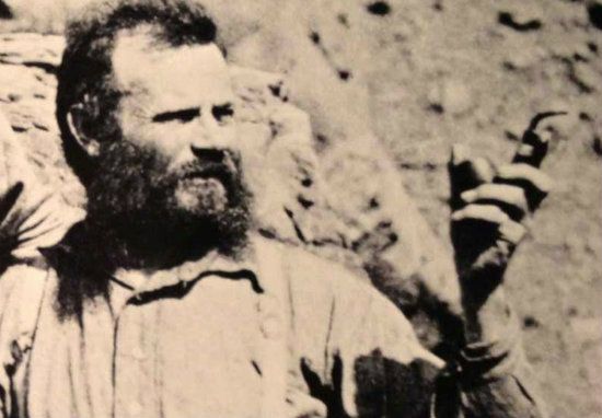
There were no pictures taken on the first expedition, but here's a photo taken on the 2nd, and look how the man aged in those two years:

Just kidding. The major just got older like everyone else and decided it was too hard to shave (him missing part of his right arm and all. . .)
Around the turn of the 20th Century, other famous river runners followed and passed through the Canyonlands region: the Brown-Stanton survey party (which was a mitigated disaster by all accounts), Bert Loper, Charles S. Russell, and E. R. Monett. Julius Stone was the first to hire a guide, Nathaniel Galloway, to take him down the river in 1909. The first motion pictures of the nexus of great canyons in the West were later filmed by Emery and Ellsworth Kolb on their 1911 lengthy odyssey. Then in 1937, Norman Nevills started commercial river trips on the Colorado River. The contemporary Twentieth Century commercial river runners and their passengers arguably had first dibs on Canyonlands best backcountry assets. In time, hikers and backpackers came to see and experience the sights by foot. Of course, so did those who preferred driving paved and unpaved roads to experience the majesty and intrigue of the future national park.
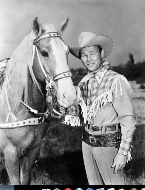
The Cowboys: As far as settlements following the Native Americans who once lived here, this sandstone-carved territory became a rugged home-on-the-range for cowboys and ranchers. Cattle grazing in the White Canyon region near Natural Bridges began in 1891. Ranchers soon found the desert country ideal for letting thousands of cows loose in various places, and where cow hands could drove the cows or round them up. (Sheep herders soon followed this practice.) The Island in the Sky district became another popular grazing locale. With cows and sheep also came rustlers. But this famous c'boy and his trusty steed was not one of the locals. . .
Why did rustlers and such prefer this setting? Because some of the canyon annexes provided ideal hideouts for famous outlaws like Robert Leroy Parker, better known as Butch Cassidy. Robbers Roost, which is west of the Maze District, also served as a secluded refuge for gangs of outlaws eluding posses led by sheriffs and marshals who probably weren't too keen on tracking desperadoes in such hostile country. Essentially, lawmen patiently waited for outlaws to venture into the open country where they hoped to coral their quarry. Mostly, the sheriffs and posses captured these desperadoes, dead or alive.
If, as it's said of Ebenezer Bryce's famous quote (about Bryce Canyon), "It's a hellava place to lose a cow," then consider how the Maze District could easily hike 10,000 or more:
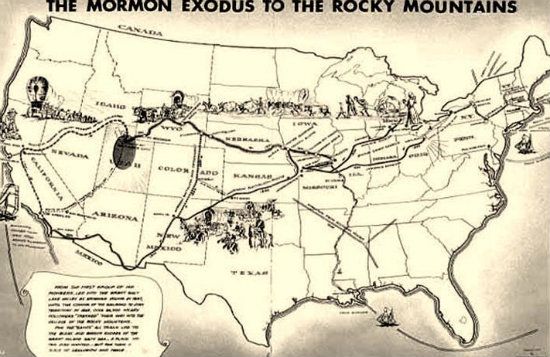
Mormons: Meanwhile, Mormons who immigrated to the Western territory in the late 1840s to avoid religious persecution of their sect denote the second large-scale emigration after the Spanish and Mexicans. There were a few Mormon settlements around Canyonlands toward the latter part of the Nineteenth Century, which were scattered throughout the state as well as into Arizona. In March 1883, the Denver & Rio Grande Railroad joined with the Rio Grande Western Railroad near Green River, Utah, and provided rail transportation to southeastern Utah. This convenience, combined with the vogue policy of moving Native Americans to reservations during the late 1900s, nurtured the growth of farming and ranching communities such as Moab and Bluff. With the Utes since removed to the Uinta Reservation, Mormon settlers soon reclaimed their abandoned pioneer community of Moab. Mormons from the town of Bluff later branched out to build Blanding, Monticello, and La Sal.
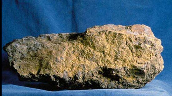
Prospectors: Despite these early settlers, much of the Canyonlands area still remained relatively inaccessible. Then came the great uranium boom in the 1950s that changed everything. The catalyst was none other than the atomic bombings in Japan that effectively ushered in the nuclear age. The Atomic Energy Commission also offered incentives for mining uranium ore.
Imagine, from this stuff the prospectors dug out of the rocks. . .
Came this bright flash and destruction. . .
The uranium-rich Canyonlands region lured droves of prospectors who stood a chance to make a great deal of money. Uranium, as it turned out, was sure gold, meaning prospecting was finally profitable. These men built and braided roads that opened up miles of previously unexplored public lands. The boom, however, was short-lived. Once the Department of the Interior set up shop (by Congressional mandate), Canyonlands was given protected status and all mining ceased. Outlaws, on the other hand, probably still used parts of the park to hide from the law. Likely, someone like this dude. . .

Canyonlands High Desert Country: The word "desert" usually conjures up visions of barren, desolate landscape void of life, with high temperatures and no water. Yet in the Southwest’s desert terrain, there’s no void here; not in this rich diversity of life and life forms. Canyonlands Great Basin Desert features abundant animal, avian and plant life representing myriad genus species. A classic high desert, geographic landforms create a climate of less than 10 inches of accumulated moisture annually, and potential evapotranspiration exceeds precipitation.
And, most certainly, there is snow in the winter:

The park lies at a latitude north of the equator where dry air masses constantly descend toward the planet’s surface. Its territory is deep in the interior of a large continent and far away from marine moisture. Thus the extended rain shadow of the Sierra Nevada Mountains. All of these factors act to produce the territory’s arid environment amounting to an average of 9.2 inches of precipitation each year. Most of this moisture comes from melting winter snows. It's the high elevations throughout the park and the winter snow that classify this region as a cold or high desert community of plants and animals. Ranging 4,000 to 6,000 feet, it’s also the dryness of the air that has an impact on the environment, where more moisture is evaporated from plants and the ground terrain than accumulates during the year. Thus, the potential for, what is called evapotranspiration, which is 8.5 inches. This figure translates to approximately 76 inches more than what is normally available! Low moisture in the air also allows more sunlight to reach the ground, thereby raising daytime temperatures, especially during the hotter months. This vital aspect of climate defines another distinguishing feature of a desert. Throughout the park the assemblage of plants and animals therefore generates a lively blend of life not found in other deserts of the world.
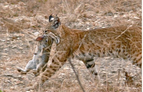
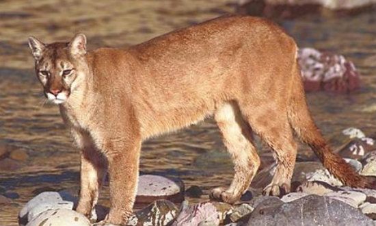
Flora and Fauna: Given the seeming scarcity of life forms in Canyonlands during the hotter months, the best chance to see critters is at night, because most prefer lower nocturnal temperatures to avoid the extremes of heat during the warmer months. Since there are fewer people and less traffic park at night, which tends to keep animals away, early morning and evening are ideal times to see mammals, from small to large and in between. The common predators––coyotes, bobcats, pumas (mountain lions) and foxes––are favorites of visitors. There’s also an amazing array of avians, including raptors, like the ubiquitous red-tail hawks. Rodents, rabbits, snakes and lizards are common as well. Insects, however, prefer darkness, especially scorpions.

In this seeming naked rock country, desert plants and trees are decidedly scarce. However, trees and plants, especially those that prefer riparian (streamside) conditions, are relatively abundant. Whether plant, tree, flower, animal or avian, each manages to survive by devising ingenious ways to adapt. Even when it appears there's no water to be found, especially during the summer heat, all is not lost. For example, drought evaders such as moss simply dry up, then suddenly come alive when moisture returns, soaking up everything nature provides. Most creatures manage to contend with temperature and moisture stresses because they are mobile, and with unique behavioral adaptations. Some even undergo adaptive physiological changes. The environment thus continues as a living, thriving desert terrain; a home to numerous plants and trees, animals of all kinds, and birds, even during periods of extreme climate.
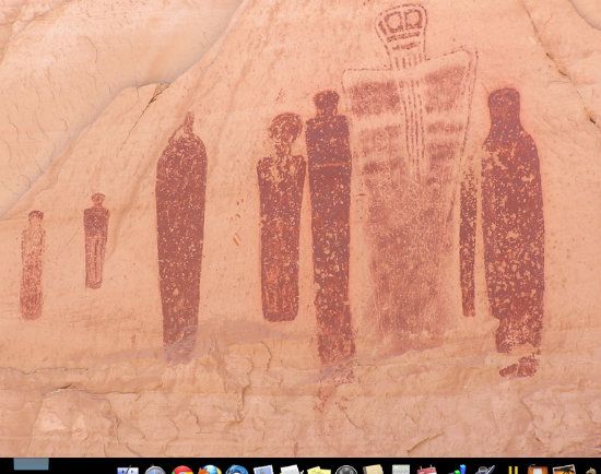
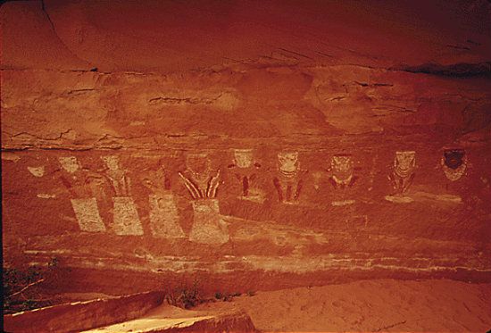
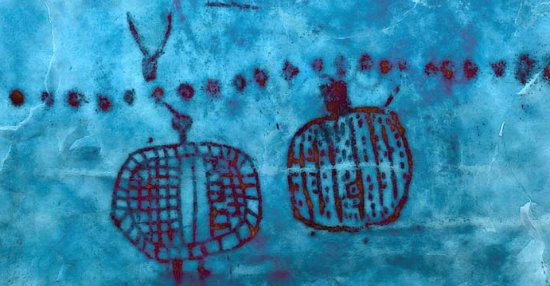
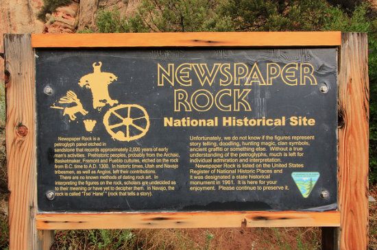
Additional Bonus Details: Hiking and driving trails within Canyonlands NP are too numerous to list. However, it's highly recommended that hikers research this information to determine what might be suitable for a day trek or even overnight backpacking. Whether by foot or vehicle, there's almost too much to see and experience here. What is best to experience depends on how much time and energy travelers have to spend and what they're mostly interested in. Some claim the best hiking in the park is the Needles district. Treks range from fairly easy to fairly strenuous. Hikers should know their limitations and rely on a practiced skill of orienteering (using topographical maps and a compass). One suggestion for those interested in the region’s primal people is to visit nearby Newspaper Rock. This large, flat-standing rock is found in Newspaper Rock State Historic Monument, situated in the Needles district. The weathered and stained surface of its acclaimed landmark boasts one of the largest known collections of symbols painted and preserved on the same surface. The 200-square-foot upright alter (for it is just that to many viewers) is part of the vertical Wingate Sandstone cliffs that enclose the upper end of Indian Creek Canyon. Literally covered by hundreds of ancient petroglyphs, this aptly named icon is one of the largest and best preserved displays of rock art in the Southwest.
The Fascination and Mystery of Rock Art: Newspaper Rock’s petroglyphs have a diverse mixture of human, animal, material, and abstract forms. Thus far, no one has been able to fully interpret their meaning. The site is old, with the first carvings made around two thousand years ago. Although a few are as recent as the early-20th Century, and left by the first modern day explorers of the region, the main group were made by the Ancestral Puebloans (1 - 1300), Fremont people (700 - 1300), and Navajo (1500 onward). Hikers can see in one setting intriguing drawings of several prehistoric to historic periods. Repatination (preserving) of surface minerals reveals their relative ages, but, again, the reason for such a large concentration of petroglyphs remains an engaging conundrum that also inspires constant debate related to interpretation. Have fun, yes, but always keep safety and common sense in mind.

Directions: From Moab, drive north on Hwy. 191 for about 10 miles (16 km) to Hwy. 313, then west toward Dead Horse Point, and follow signs into Canyonlands. (Hwy. 191 is south of I-70 and north of Monument Valley, on Hwy. 163). For the Needles District, take Hwy. 191 south of Moab for about 37.5 miles (60.3 km), then go west on Route 211, and follow the road into the park. For the Maze District on the other side of the Green River, which is mainly four-wheel-drive terrain, take Hwy. 95 near Hite (on Lake Powell) or else Hwy. 24 via Hans Flat, and take the turnoff (for Hans Flat) north of Hanksville. For Horseshoe Canyon, which is south of the Goblin Valley turnoff, go north of Hanksville to a dirt road heading east from Hwy. 24 (which during inclement weather is passable only with four wheel drive).
Contact Information: Canyonlands National Park, 2282 SW Resource Blvd, Moab UT 84532. Phone (General Information): 435-719-2313; Backcountry Information: 435-259-4351. Fax 719-2300. Typical NPS Email: http://www.nps.gov/... %20%20%0A&r=/cany/index.htm
And so, DKos community, we come to the end of another trail, another armchair tour. I trust you learned a thing or two from the spiel. Stay tuned for tomorrow's special diary: two relatively easy hikes in Canyonlands (and one the park service is reticent about giving directions to its locale).
As always, your thoughtful commentaries are welcomed.
Rich
http://www.nmstarg.com/...
http://www.grandcanyon.org/...
Here is a parting shot that may entice or evince you to one day to visit (or return) and see this magnificent national park from a closer view:

P. S. In case you haven’t read any or some of the other diary-missives posted on this site, here is a current list you might be interested in reading:
An Archeological Timeline:
http://www.dailykos.com/...
Colorado Plateau Human History:
http://www.dailykos.com/...
Zion Canyon (Hiking the Subway):
http://www.dailykos.com/...
Zion Canyon NP:
http://www.dailykos.com/...
Geology 101:
http://www.dailykos.com/...
Ethnobotany:
http://www.dailykos.com/...
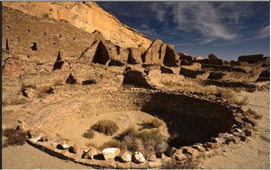
Chaco Canyon series:
http://www.dailykos.com/...
http://www.dailykos.com/...
The Colorado Plateau series:
http://www.dailykos.com/...
http://www.dailykos.com/...
http://www.dailykos.com/...
Res Dogs (prologue and chapter series):
http://www.dailykos.com/...
http://www.dailykos.com/...
Bryce Canyon NP:
http://www.dailykos.com/...
The Art of Backpacking:
http://www.dailykos.com/...
George Steck Vintage Glen Canyon film:
http://www.dailykos.com/...
A Companion Narration (for George Steck film):
http://www.dailykos.com/...
Monument Valley Tribal Park:
http://www.dailykos.com/...
The Lost Atlantis (Glen Canyon):
http://www.dailykos.com/...
Glen Canyon-Lake Powell series:
http://www.dailykos.com/...
http://www.dailykos.com/...
http://www.dailykos.com/...
http://www.dailykos.com/...
A Most Surprising Christmas:
http://www.dailykos.com/...
http://www.dailykos.com/...
(end)
