Trying to end the year on a positive note I always look back to my experiences in our National Parks, National Monuments and National Forests. These are among America's best ideas and still I worry in these penurious times about their future. But, this year I was able to return to Dinosaur National Monument, paddling on the Yampa to complete my journey through all areas of the monument.
Created in 1915, Dinosaur National Monument encompassed the Carnegie Quarry in the Morrison Formation. This quarry with it's Jurassic dinosaur bones is what most of the 260,000 visitors come to see. Here is a part of the wall. This section of the Morrison Formation was a riverbed. And, look at the alignment of the large bones, probably due to movement by rapidly flowing water. Other layers of bones have more random alignment due to drier conditions.
Far fewer people take advantage of the entire park with its marvelous canyons; Lodore, Whirlpool, Split Mountain, and The Labyrinth, all added in 1938. These canyons are at the Northernmost border of The Colorado Plateau and were the first major canyons, and rapids, encountered by the Powell expedition in 1869.
Lodore, the Northernmost of the canyons spectacularly divides the East-West trending Uinta mountains, the Green river cuts southward 18 miles from "The Gates of Lodore" to Echo Park and the confluence with the Yampa. This deep, narrow canyon, contains rapids all named by Powell and his men; Disaster Falls, Triplet, Hell's Half Mile. Disaster Falls was named when Powell's men lost the boat, No Name, and were left struggling to make the shore.
"The first fall was not great, only two or three feet, and we had often run such, but below it continued to tumble down 20 to 30 feet more, in a channel filled with dangerous rocks that broke the waves into whirlpools and beat them into foam. I turned just to see the boat strike a rock and throw the men and cargo out. Still they clung to her sides and clambered in again and saved part of the oars, but she was full of water, and they could not manage her. Still down the river they went, two or three hundred yards to another rocky rapid just as bad, and the boat struck again amid ships, and was dashed to pieces. The men were thrown into the river and carried beyond my sight."
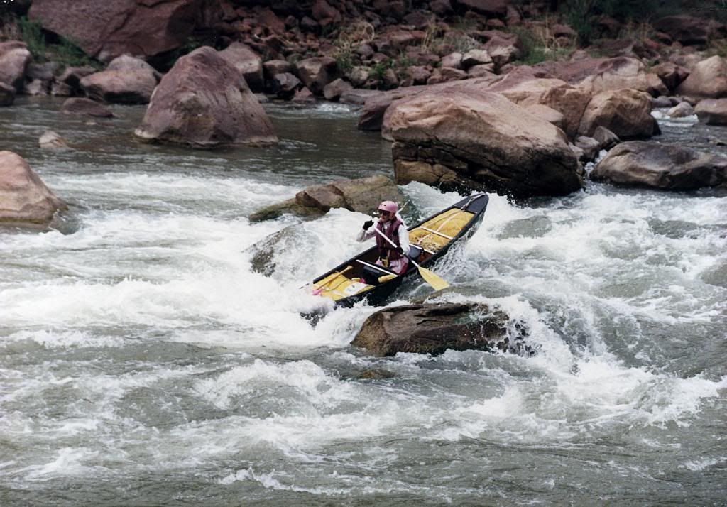
Here is my spouse as she runs Disaster Falls. Here calm demeanor belies the thoughts that go through one's mind.
But, regardless of the excitement, the scenery and geology are spectacular. Through Lodore, one may follow the faulting that influenced the path of the Green River . . . until Steamboat Rock, here, wakes you up to the recognition that you have just entered the monolithic sandstone of the Colorado Plateau. It is in this realm, that Powell correctly surmised that the Green River preceded mountain building and uplift. The Yampa river enters the Green here and at the confluence is Echo Park, a backcountry campground for intrepid car-campers.
Above is the entrance to The Labyrinth from Wagon Wheel Point. In the canyons of the Yampa river one is surrounded by the sandstones of the Pennsylvanian period, much older rock than the Jurassic of the Quarry.
Touring along the Yampa one is treated to vertical sandstone walls, sometimes coated with desert varnish, where high above the present river, scars of old meanders are seen. Rapids here are caused by side canyons dumping debris into the Yampa during floods - except at Warm Springs Rapid where a slab of the overhanging wall dropped into the Yampa in the fall of 2012, augmenting an already nasty rapid. For luck and safe passage one plants a kiss on the Tiger Wall, on the right.
Through Whirlpool Canyon, from Echo Park to Rainbow Park, the theme of Pennsylvanian sandstone continues, and the river runner can lay back and relax. Along the way, a clean, clear little river, Jones Hole Creek, enters the Green. Camping here is a joy. A short hike up the creek leads to Freemont petroglyphs and pictographs. Always a fascinating visit to ponder that we are preceded by peoples who knew our continent in a different way.
Finally, exiting Whirlpool Canyon, the Green River lazily wanders through Rainbow Park and, hidden from view until nearly the last minute, is the Split Mountain Anticline.
On my first trip through here, I was totally unprepared to see this; a naked anticline that the Green river splits from North to South. I was so in awe that in this section I spent more time looking at the geology than the river and let a little wave flip me. Alas, at the end of Split Mountain is the take-out, the end for any river trips through Dinosaur National Monument.
For those wanting more information, besides the Dinosaur National Monument website, there is the "Dinosaur River Guide," Belknap, Westwater Press.
I hope those of you who have the opportunity will visit and explore this and the other units of our National Park system. When people think about canyons, and about whitewater, their thoughts usually go to the Grand Canyon and they little realize the spectacular canyons of the Green and its tributaries on the Colorado Plateau. One section, Desolation and Gray Canyons, just above Green River Utah in the Tonto National Forest is stunning, yet remains unprotected, but much loved by river rats.