The Grand Coulee, North Central Washington State
October, 2015
The third leg of my October trip over the North Cascade Mountains (first and second here) into the cataclysmically shaped Eastern Washington landscape included visits to:
- The terminal Moraine of the Okanagan lobe of the giant Pleistocene’s Cordilleran Ice sheet,
- The terrain engraved by the Ice sheet and resultant massive floods down the Columbia River drainage, such as The Grand Coulee and Dry Falls,
- The Grand Coulee Dam – a modern day American engineering wonder,
- The upper Columbia River below the Grand Coulee Dam
|
The Daily Bucket is a regular feature of the Backyard Science group. It is a place to note any observations you have made of the world around you. Insects, weather, meteorites, climate, birds and/or flowers. All are worthy additions to the bucket. Please let us know what is going on around you in a comment. Include, as close as is comfortable for you, where you are located. Each note is a record that we can refer to in the future as we try to understand the patterns that are quietly unwinding around us.
|
Remnants of the Cordillian Ice sheet:
We began heading east from Chelan, across the Columbia River and up onto the Columbia Plateau. In what would generally appear to be a desolate farming area with few points of interest, our guide (GaryK) directed our attention to several geologic features worthy of attention. First, we were in the vicinity of the southern and terminal edge of the Okanagan lobe of the Cordilleran Ice Sheet. What looks like generic hills to the uninformed eye, were in fact the terminal moraine itself. These hills had been built up and pushed along as the ice sheet plowed south until it eventually stopped, melted, and receded, leaving its freight as hills.
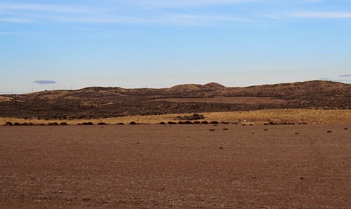 Terminal Moraine of the Okanagan Lobe of the Corderillian Ice Sheet.
Continuing north and east onto the Waterville Plateau where the ice sheet last had been some 17,000 years ago, we saw in the fields what appeared to be haystacks. In fact they are called Haystack Rocks. These are large lumps of basalt that had been carried along with the ice sheet as it moved west and south and finally were deposited here when the ice melted. Although there is much basalt along the river and south, there are no actual basalt outcroppings in this area. Thus, these hay stacks are erratics, and some big ones at that.
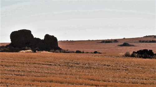 Haystack rocks, erratic basalt boulders in a wheat field
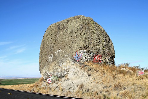 One hunkin’ big erratic
The Grand Coulee:
A coulee is a broadly used term referring to a water drainage system, typically one that has been carved by erosion. The term coulee comes from Canadian French, coulee, from French, meaning “to flow.”
The Grand Coulee is a specific, large coulee set in north central Washington State and is the product of multiple forces that eroded the ancient basalt flows.
This coulee was carved out of the basalt over many thousands of years by a combination of forces. At one point, this coulee might have been the river bed of the Columbia River that was subsequently displaced to its present course, a short way to the north by various glacial ice sheets during the Pleistocene era. However the Grand Coulee itself is considered too large to have been eroded by the Columbia River alone. Portions of the Corderillian Ice sheets, the Lake Missoula floods, and the Lake Columbia floods, most likely contributed to this scabbed and scrapped waste land.
The coulee runs about 25 miles long and is greater than 2 miles wide for most of this length with sheer vertical walls rising to around 700 feet. The entire Grand Coulee is spectacular in itself but it has several standout geological features that in part define it.
Upper Grand Coulee has been dry since the last floods receded, but is now an artificial lake (Banks Lake) holding water pumped from Grand Coulee Dam’s, Lake Roosevelt. The water is then dispersed into the Columbia Basin Irrigation Project.
Within this shallow reservoir sits Steamboat Rock: a massive hunk of basalt that now rises 742 feet above Banks Lake.
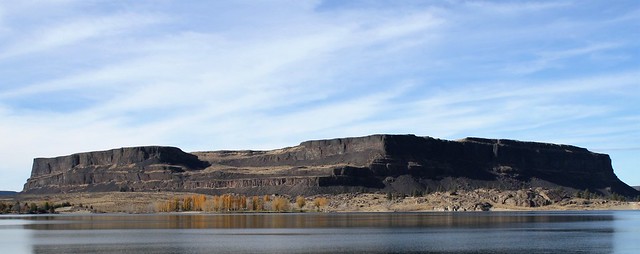 Steamboat Rock, Upper Grand Coulee, Banks Lake.
The multiple floods that eroded the coulee left this basalt butte as a sentinel that became a landmark to all who traveled through this area as noted on the sign below. Today this huge mesa hosts a popular State Park at its foot, and numerous hiking trails on and around it.
 Steamboat Rock history, Grant County, WA
Moving south down Banks Lake, we come to Coulee City where a Department of Reclamation dam is located that retains the water of Banks Lake to be distributed for irrigating over 600,000 acres of prime farm land of the Columbia Basin.
Dry Falls
A short way south of Coulee City and the Upper Coulee, we come to a second monumental geologic feature - Dry Falls, located in the Lower Grand Coulee.
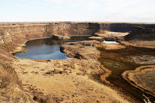 A portion of Dry Falls
Although Dry Falls is now dry, this structure is believed to have once been the largest waterfall in the world. The water now seen below in the lake is runoff and seepage. The full falls is so extensive that it is difficult to photograph the whole thing at one time unless in panorama or from an aerial perspective. Below is a video of the dry falls. The fall’s shelf over which the torrents flowed, curves even further around to the right and then back north. (See the video)
|
DRY FALLS IS A 3.5 MILE LONG SCALLOPED PRECIPICE IN CENTRAL WAshington, ON THE OPPOSITE SIDE OF THE UPPER GRAND COULEE FROM THE COLUMBIA RIVER, AND AT THE HEAD OF THE LOWER GRAND COULEE. AT FIVE TIMES THE WIDTH OF NIAGARA, DRY FALLS IS THOUGHT BY SOME TO BE THE GREATEST KNOWN WATERFALL THAT EVER EXISTED, BUT THE REFILLING OF THE MEDITERRANEAN 5 MILLION YEARS AGO PROBABLY DWARFED IT. ACCORDING TO THE CURRENT GEOLOGICAL MODEL, CATASTROPHIC FLOODING CHANNELED WATER AT 65 MILES PER HOUR THROUGH THE UPPER GRAND COULEE AND OVER THIS 400-FOOT (120 M) ROCK FACE AT THE END OF THE LAST ICE AGE AT THIS TIME, IT IS ESTIMATED THAT THE FLOW OF THE FALLS WAS TEN TIMES THE CURRENT FLOW OF ALL THE RIVERS IN THE WORLD COMBINED.
|
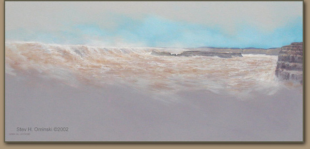 Depiction of Dry Falls when it was flooding. This Painting is posted at Dry Falls State Park, Artist: Stev Ominski
As the great floods from Lakes Missoula and Columbia raged down the Grand Coulee and over the falls, they tore loose chunks of basalt from the shelf, dashing them into the plunge pool below. Progressively, over many such floods, these falls have eroded up stream some 15 miles from where they started around what is now Soap Lake.
A little way below Dry Falls and down the coulee our guide pointed to another erosion - produced feature in the landscape that we would never have figured out on our own. This is the remnants of a monocline. A monocline is a stratum of earth that drops down from an otherwise flat lying horizontal surface.
In this case the monocline is truncated, with the flat lying surface above the hill to the left in the photo below, the middle part was washed away by the eroding flood waters. What we now see in the photos below is a cliff that has been eroded and in the second photo, two triangular blocks of the same strata that are in the bottom of the coulee. The layered strata are angled upward pointing to where they once were attached to the cliff. At one point before the floods, these layers were continuous, although sloping downward.
 Upper Strata of Monocline
.JPG?1450130395 "DSCN1025_(3).JPG") Lower limb of Monocline strata
Lower limb of Monocline strata
The Grand Coulee Dam
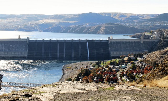 The Grand Coulee Dam from the Crown Point Gazebo
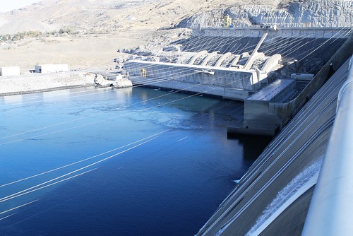 Third power plant in the center, looking down on the spillways from atop the dam.
Native Americans first inhabited the Columbia Basin around 11,000 years ago. Because of the dryness they avoided much of the Columbia Plateau, preferring to stay closer to the Columbia River with its bountiful salmon runs and to be closer to the mountains for bigger game.
In spite of the dryness, European settlers came to the area in the mid 1800s. It was apparent to them that there was much potentially fertile land that only lacked irrigation water and there was a seemingly endless supply in the huge river nearby. The future they believed was a dam from which they could draw irrigation water.
The concept for damming the Columbia River began in the early 1900s when local attorney, William “Billy” Clapp originated the idea that ultimately took root and developed into a plan to build Grand Coulee Dam. They hoped that this dam would provide irrigation water for a million acres of the Columbia Plateau and Basin in Central Washington. Three local attorneys championed the project and floated a county bond issue to pay for it. Although this bond issue failed, the concept lived on. During the New Deal era Congress and President Roosevelt became involved and the rest is history.
After much political haggling, construction began in 1934 which is a story in itself and began basic functioning in 1942. Expansion of both the electrical and the pumping project and irrigation water distribution continued for years before fully completed. The full Columbia Basin irrigation was not fully functional until 1952.
|
Grand Coulee Dam dwarfs the Great Pyramids of Egypt and generates more power than a million locomotives. An engineering wonder, it is also the country’s largest hydroelectric project. Grand Coulee Dam is one of the largest concrete structures in the world, containing almost 12 million cubic yards of concrete. It towers 550 feet above bedrock (as high as the Washington Monument) and is 500 feet wide at the base. There is enough concrete in the dam to build two standard six-foot wide sidewalks around the world at the equator.
|
 Irrigation water pumping pipes. Each pipe going uphill is 12 ft in diameter. Water is pumped into Banks Lake on the other side of the hill. Photo taken from atop the dam
Although the Grand Coulee Dam is not technically in the Grand Coulee itself, the two are clearly connected as the Columbia River probably flowed through the Grand Coulee historically before being redirected to its present course. They are also related in that the original purpose of building the dam was to use its reservoir from the backed up Columbia River as a source of irrigation water. That water is now pumped into the Upper Grand Coulee as Banks Lake seen above.
A Caveat on the dam.
|
I have One Caveat on the magnificence of the Grand Coulee Dam. As much as the irrigation did and does for the agricultural productivity of the Columbia Basin and the cheap power it produces for the region, it also decimated the upper Columbia River salmon. When the dam was built, the Corp of Engineers did not include a fish ladder to allow passage for the huge Columbia River salmon runs that came through this region and that were a major subsistence fishery for the local Indians. With the loss of the salmon, went a huge part of their food and culture that had sustained the tribes for thousands of years. The dam was too high for a ladder. This omission wiped out the salmon runs throughout northern Washington and all the way up into Canada. They were lost forever.
|
Down the Columbia River Drainage
Heading home, I first traveled from the Grand Coulee along the upper Columbia River drainage which has some remarkable geologic features of its own. The title image at the top of this diary is from this stretch of the the river.
 Lincoln Rock, Columbia River, Chelan County
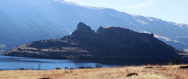
Like Steamboat Rock in the Grand Coulee, Lincoln Rock, situated in the middle of Columbia River is a large sphinx-like basalt mass. From a certain perspective, the rock formation forms a likeness of Abe Lincoln, hence its name.
A bit further south and towering along the Columbia River, “Broken Mountain” as it was called by the local Indians (Ribbon Cliff today), was formed when a 1872 earthquake literally broke the mountain. The resultant rock slide blocked the river’s flow for several hours. The ribbons seen in the cliff face are lava fissures that infiltrated the base rock and likely weakened it such that it split off during the quake.
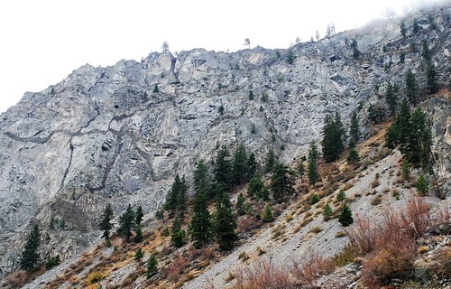 Ribbon Cliff (Broken Mountain) along the Columbia River
The final image from this trip was captured by my brother just a short way passed the Broken Mountain along the Columbia River. These majestic Bighorn Sheep were once widely distributed throughout the west, ranging from Alaska to Mexico. Due to over hunting, disease, and human encroachments, the Bighorn Sheep nearly disappeared by the early 1900s. However due to a recent highly successful restoration program their numbers are rebounding.
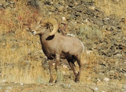 Bighorn Sheep along the Columbia River, Chelan County, WA (Attribution: DickK)
This completes my four day trip to east side of Washington State exploring the astounding geologic and man-made history that has formed and transformed this region. If anyone is interested in the Ice Age Floods that sculpted this area, I refer you the trail map and this website.
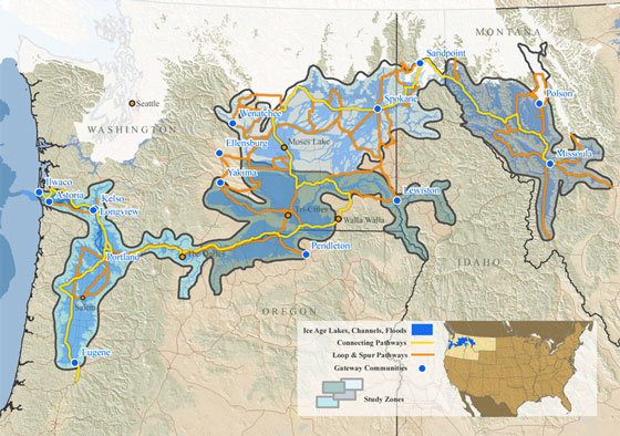 Route of the Ice age Floods National Trail,
Other diaries in this series:
Lake Chelan: www.dailykos.com/…
North Cascades Highway: www.dailykos.com/…
Ice age Mammoth Dig: www.dailykos.com/…
Columbia Reach, Erratics, Hanford nuclear Reservation: www.dailykos.com/…
Columbia Plateau, floods, and viticulture: www.dailykos.com/…
 "Spotlight on Green News & Views" will be posted by Meteor Blades every Saturday at 1:00 pm Pacific Time and every Wednesday at 3:30 Pacific Time on the Daily Kos front page. Be sure to recommend and comment in the diary.
Your turn: What’s going on in your neighborhood and surroundings? What bit of nature have you observed recently that you’d like to share?


