Larger Image
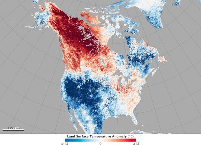
The map above shows North American land surface temperatures from May 17–24, 2015, compared to the 2001–2010 average for the same eight-day period. Shades of red depict areas that were hotter than the long-term average; areas in blue were below average for the week. White pixels were normal, and gray pixels did not have enough data, most likely due to excessive cloud cover. NASA Earth Observatory
This temperature anomaly map is based on data from the Moderate Resolution Imaging Spectroradiometer (MODIS) on NASA’s Terra satellite. Observed by satellites uniformly around the world, land surface temperatures (LSTs) are not the same as air temperatures. LSTs reflect the heating of the land surface by sunlight and they can sometimes be significantly hotter or cooler than air temperatures. (To learn more about LSTs and air temperatures, read: Where is the Hottest Place on Earth?)
On May 23, the air temperature at Fairbanks International Airport reached 86 degrees Fahrenheit (30 degrees Celsius), breaking the record of 80°F (26.7°C) from 2002. That same day, thermometers hit 91°F (32.8°C) in Eagle, marking the earliest 90-degree day in state history. The town had nine consecutive days above 80°F. In Barrow, Alaska, on the shores of the Arctic Ocean, temperatures climbed to 47°F on May 21, close to 18°F above normal. Temperatures normally do not reach that high until mid-June.
To the south and east, at least 12 temperature records were set in Canada’s Yukon and Northwest Territories. Temperatures in Faro reached 81.3°F (27.4°C), 14°F (7.5°C) above the old record. With humidity levels between 10 and 20 percent, civil agencies warned of wildfire. At least 31 fires were reported in the Yukon alone as of May 24.
The town of Eagle Alaska, near the border with the Yukon Territory experienced temperatures in the 80's for seven straight days. The warmest was 86. Interior areas of Alaska are now experiencing high fire danger areas, rapid snow melt that is draining into rivers. On Monday, the
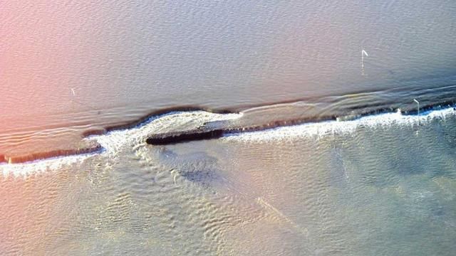
Dalton Highway which is the only road to the North Slope oil fields, was shutdown by up to 2 feet of water flooding the road.
The image below is not a picture from flood ravaged Texas or Oklahoma. This image was taken at mile post 394 on the north slope of Alaska.

Flooding and erosion of Alaska's Dalton Highway at milepost 394 on May 18, 2015. (State of Alaska Department of Transportation and Public Facilities)
Weather.com explains that this happened due to Super Typhoons, Noul and Dolphin.
"A series of two western Pacific super typhoons -- Noul and Dolphin -- have done a number on the (jet stream) pattern across the north Pacific following their extratropical transition," says Dr. Michael Ventrice, Operational Scientist at The Weather Channel Professional Division.
Ventrice says the ex-typhoons created "high-latitude wave breaking," creating a pronounced northward diversion of the jet stream over the eastern two-thirds of Alaska and northwest Canada.
A subtle southward dip in the jet stream, or trough, may edge far enough east from the Bering Sea to take the top off temperatures in Alaska's interior early next week.
Otherwise, blocking high pressure aloft -- known by meteorologists as an "omega block" because it resembles the Greek letter omega -- will generally remain over Alaska and western Canada into much of next week.
This means more 70s along the Gulf of Alaska coast, 80s in the interior, and yes, more highs flirting with the 40s in Barrow.
The
global view can be see here.
NASA explains:
The global view of land surface temperatures for May 17–24 reflects cooler temperatures in eastern Canada, where vineyards lost some of their crop due to late-season frost. In the southwestern United States, cooler temperatures and data gaps reflect the persistent cloud cover and rainfall over much of the area.
Around the world in southern Asia, however, the LST map shows its limitations. India has also been caught in a heat wave. However, the MODIS sensor did not observe a single cloud-free day across the entire country in the eight-day period. Cloudy patches on different days over different parts of the country may have caused the heat signal to be smoothed out. It is also possible that warm, humid air masses were more responsible for the heat wave than direct solar heating of the ground. Either way, daytime land surface temperatures did not register as anomalous compared to other years.


