Good evening, Kibitzers! I know you have been following the volcano news from Hawaii. It’s worrisome and sad for the people whose homes and lives are involved, but there’s no denying it’s also fascinating. I visited Hawaii Volcanoes National Park, near where this activity is taking place, ten years ago. Some of my pictures might be interesting in this context.
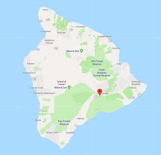
In the past, I’ve posted some of my favorite pictures from that trip, of the observatories at the 14K-foot summit of Mauna Kea, and when I saw eruption headlines, I had to think for a minute — but no, Mauna Kea is not an active volcano (which is why they felt okay about building half a dozen fancy observatories and a visitors’ center on it). It’s the little green “pin” in the northern part of the island on the map, about in the middle. Kilauea, at the red “pin”, is the culprit in this case. Hawaii Volcanoes National Park includes its summit, and it’s been erupting continuously since 1983, just not in a big splashy Pompeii sort of way . There are definitely structures at the top of Kilauea too, but Hawaiian Volcano Observatory, on the rim of the caldera, keeps a pretty close eye out, and anyway, being outside the park is no guarantee either, as we’ll see.
Let’s start by looking straight down. From the ISS:
You can see there’s a big roundish flat area, which is the caldera of the volcano. That’s not the same thing as the “crater” or “vent”, the hole where the lava comes from (or the baking-soda foam, in the case of papier-mâché volcanoes). It’s a larger area that forms when the cone collapses into itself. The actual crater, whose name is Halemaumau, is the smaller, deeper roundish area at the top of the caldera in the image, with the big plume of ash/steam/etc. coming out of it.
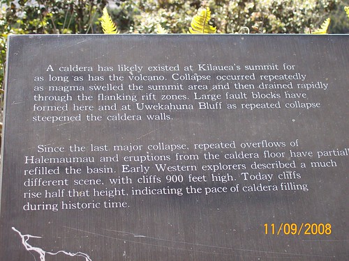 “A caldera has likely existed at Kilauea's summit for as long as has the volcano. Collapse occurred repeatedly as magma swelled the summit area and then drained rapidly through the flanking rift zones. Large fault blocks have formed here and at Uwekahuna Bluff as repeated collapse steepened the caldera walls.
Since the last major collapse, repeated overflows of Halemaumau and eruptions from the caldera floor have partially refilled the basin. Early Western explorers described a much different scene, with cliffs 900 feet high. Today, cliffs rise half that height, indicating the pace of caldera filling during historic time.”
You can walk to the rim of the caldera, and drive around it except as they may close areas because of fumes or some similar threat — it’s a long way around, about 11 miles. In most directions, it looks pretty harmless.
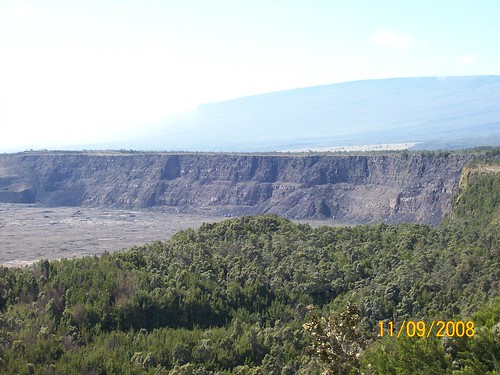 These are the cliffs that the explanatory sign above says were once 900 feet high but are now only half that, because the caldera gradually filled with lava.
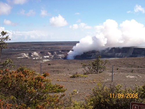 And then there’s Halema’uma’u.
A photo by the US Geological Survey from a higher vantage point lets us look down into Halemaumau, set into the floor of the caldera that stretches out around it. Most of its floor is hardened lava too, but one corner is busier.
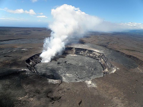 Public domain: US Geological Survey
A new vent had opened in March of 2008, 7-8 months before my photo, forming a lava lake there that has been circulating ever since. That’s what you see fuming in both the above pictures. At this link is a pretty amazing USGS time-lapse video of the lake overflowing across the Halemaumau floor about three weeks ago — the most extensive of the overflows shown covered about 90 acres.
Here’s how the lake looked at night in November 2016:
All that, though, isn’t really what’s causing the trouble now, at least so far. We said before that Kilauea has been erupting since 1983, and then we said there wasn’t much doing in Halemaumau until 2008. That’s because Kilauea has another trick. Unlike your baking soda volcano, it can tear fissures in the ground anywhere along the underground path of the magma that’s feeding the volcano, and push lava out of them, either as a slow ooze or as violent explosions that send “lava bombs” high into the air. It’s opened 18 new fissures as I write Monday night; it’s been some years since it last destroyed houses and roads outside the park, but this is not the first time it’s done so.
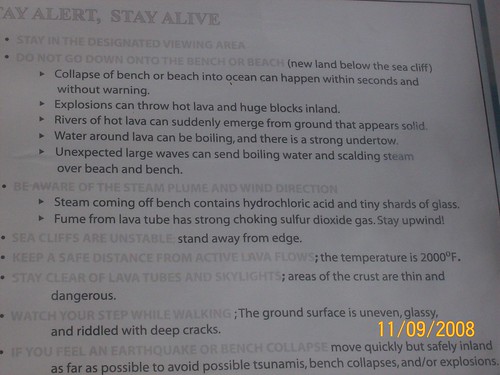
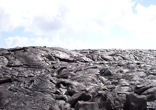
In 2008, lava emerging in the “Lower East Rift Zone” was dropping into the sea. We drove out to where you could see how it had passed over land some years earlier, and it still covered and blocked the road a few miles in. We didn’t make the lengthy hike to the coast from that point to watch it hit the water. We’d showed up in the afternoon, not at all dressed to hike across lava rock, and so we just took some lava photos and admired the dire warning sign. (“Steam coming off bench contains hydrochloric acid and tiny shards of glass” won the prize as the item we’d be least likely to tell our moms about.)
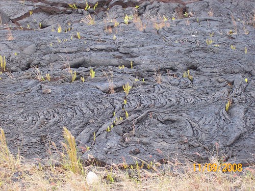 After some time, the lava rock starts to weather and plants start moving in.
Now, the Lower East Rift Zone is again getting unwelcome visits from Pele manifesting as lava. The residents of the affected area are at risk not only from lava flows, but also lava fountains, steam jets, and “spattering”, where explosions can launch hunks of hot lava rock high into the air. The existing fissures may emit further lava, and new fissures may open up in either direction along the rift. There could still be a more active eruption from Halemaumau at the summit, especially of heavier ash, and seismic activity is elevated everywhere.
The National Park Service’s “plan your visit” page for the park has some interesting videos and also, if you scroll down, quite up-to-date news and warnings about volcanic activity. (That’s because they do volcano monitoring.) This is Daily Kos, so I don’t need to say any more of the stuff I’m thinking about the proper uses of government and our taxes. So now, since I’ve said and shown and linked everything I’ve got on this, I’m ready for all the lurkers with PhDs in volcanology to show up and tell me I’ve got it all wrong. ;)
|
Kitchen Table Kibitzing is a community series for those who wish to share part of the evening around a virtual kitchen table with readers of Daily Kos who aren’t throwing pies at one another. Drop by and tell us about your weather, your garden, or what you cooked for supper. Newcomers may notice that many who post diaries and comments in this series already know one another to some degree, but we welcome guests at our kitchen table, and hope to make some new friends as well.
|
|
It is now 16 days until the new hurricane season starts.
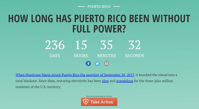 I grabbed this screenshot overnight from the NY Daily News interactive page on the crisis in Puerto Rico. HERE is the live page, with more details and a “Take Action” button. The page is a very good link to share on social media.
PUERTO RICO and USVI DISASTER RELIEF DONATION LINKS
The Daily Kos community has its own project: Puerto Rico resident Bobby Neary (newpioneer) leads a small team dedicated to helping a specific rural elder who was left by the storms without power, water, a roof, or any belongings but a moldy mattress. If you like to see concrete results, this is the project for you. See newpioneer’s diaries for ways to help. See this one in particular, and this comment with photos.
PLEASE FOLLOW Denise Oliver Velez and the SOS Puerto Rico group for the latest news about developments in Puerto Rico and the USVI. Denise’s most recent Puerto Rico diary is here.
|