It's eldfjallavakt time here at Daily Kos, as Iceland's extremely dangerous volcano Bárðarbunga keeps up its activity. Join me below the magma-colored squiggle for the latest news!
(reminder: It's pronounced "BOWR-thar-Boon-ka" :) )
Well, after receiving almost no news coverage, Bárðarbunga - Iceland's biggest volcano and the "big sister" of Laki (the deadliest volcano in recorded history) - is finally starting to get noticed by the news. Good! This is one to watch even if you're not as close to the eruption as I am ;)
Let's get you all updated!
1. Is she still threatening to erupt?
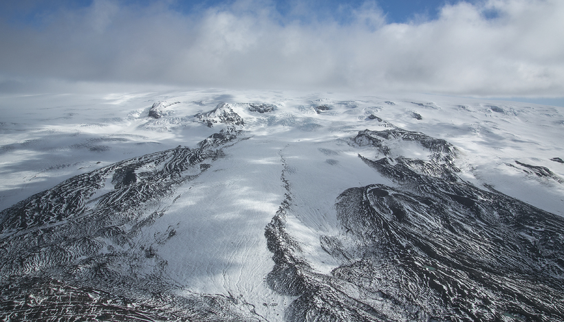
Yes! Here's an animation I made showing her rumblings over time. But some others have made IMHO more interesting graphs (which I'll link later)
The Icelandic Met office considers it likely that Bárðarbunga will go off. She currently has an orange indicator for aviation warning maps, the highest ranking possible without the volcano being in a state of eruption. Seismologists report that their GPS meters show continual uplift and that all signs show the magma is on the move. There is no indication that quake activity is on the decline
2. Does that mean that she absolutely will erupt?
No. It's quite possible that the magma could stop moving and she could calm down again. We don't know right now.
3. How are people monitoring the volcano?
There are many different ways. As you can see, there's quake and GPS montioring. There are flow meters on the rivers heading out of the glacier. There's also a webcam where anyone can see any eruptive activity live. Iceland is also re-routing one of its data-collection aircraft from a mission in Italy (it'll be back this evening).
4. How are people preparing for the eruption?
The general public, not much; however, the government and municipalites are actively going over their disaster plans. Roads in the area are closed. A mobile radar dome is being deployed to near the volcano to get good readings on the potential ash cloud.

5. What's going on underground?
Some nerds with more time on their hand than me put together some great animations where you can see how the magma has shifted with time.
First, an interactive map.
Another great interactive page is here.
Now, some videos:
6. What would be the global consequences?
It totally depends on the size of the eruption. Laki's last major eruption changed the weather so much that there was ice in the Gulf of Mexico and the Nile almost entirely dried up, and emitted so much poisonous gas that tens of thousands died from the direct consequenses of gas inhalation in Scotland. The level of gas emission was over ten times that of Mt. Pinatubo, the largest eruption fo the 20th century. Bárðarbunga hasn't had as big of eruptions in modern times, but its pre-settlement eruptions have been as much as twice as big as that eruption.
Let it suffice to say, "major". IF it's a big eruption. However, as noted, just because a volcano can have big eruptions doesn't mean that they will be big; more often, they're on the smaller end of the volcano's capabilities. Which we all certainly hope for!
7. What would be the consequences in Iceland?
Right now, scientists are predicting that she'd launch a major flood north down the Jökulsá á Fjöllum river, as the eruption would be under as much as 800 meters of ice. That could be nearing the outflow of the Amazon River, racing down the highlands to the sea. The trip would take 9 hours. Dettifoss, currently the most powerful waterfall in Europe, would be getting a LOT bigger. If the water makes it into Ásbyrgi, the area would be scoured clean. The whole river landscape would be utterly transformed by that much water, it's enough to hurl boulders around like playtoys.
That's the good scenario. Because if the flood went west instead of north, it coul take out almost half our power supply. And with loss of power we'd lose our aluminum industry, with permanent damage to the facilities. Regardless of the strength of the eruption, it'll probably kill tourism here for a good while. What affect it'd have on our fishery is unknown.
If it's a high gas eruption like Laki, we could have another "mist hardships", where an acrid, dangerous fog descents on the country for a year or so. Hopefully that won't be the case - things like that are thankfully pretty rare. Laki also contaminated the water supply with excess fluorine, leading to severe skeletal fluorisis in people; about 80% of the sheep and 50% of other livestock died as well from fluorisis and ash falls. Again, that's a worse case. I think farmers today could better protect the other livestock, but the sheep are pretty vulnerable, they graze loose up in the mountains this time of year and the roundup isn't for another month.
So yes, I'm very hopeful that this doesn't become another 8 month gassy fissure eruption and instead is just a nice friendly "tourist eruption"! Or that it doesn't happen at all, which - as mentioned earlier - could still happen.
I'll keep you all updated!
Update #1, 21:00 12 august: And we have this:
Magma believed to be streaming into the volcano with great force
A general warning has been issued this evening concerning the degree of danger north of the Dyngujökull glacier and it has been decided that the highlands there will be vacated. A great quantity of magma is considered to be streaming up into the Bárðarbunga volcanic system and scientists say that the event is extremely powerful. The transportation office says that the bridges over the Jökulsá will not survive a catastrophic flood like the one that hit Skeiðarársandi 18 years ago. Tremors now are calling attention and the air traffic control managers have now prepared to close the airspace because of the possibility of ash clouds.
The volcanic system Bárarbunga is now considered threatening and the reaction of the authorities to it has become extensive. North of Vatnajökull glacier, where it's feared that a flood sturge will break out, highland roads have been closed and all traffic banned, both driving and walking. Bárðarbunga is now in the world news, with the international media raising the issue of the disruption that Eyjafjallajökull caused in 2010.
From the seismometers of the Met Office specialists see that the activity within Vatnajökull is continuing to be strong. Kristín Vogfjörð, a seismologist and investigator of the Met Office, says that this is a very powerful event.
"Therefore this is simply moving forward. There's a great deal of activity, this is many times more now than what's happened over the previous years."
Kristín says that there's a great volume of magma streaming under the volcanic system and to the northeast in the irection of Kverkfjall. She says that the magma is remaining 5 to 10 kilometers underground and does not see a sign that it's on the way to the surface. When asked whether she thinks it probable that an eruption will begin within a day she responded:
"I don't think so. There's nothing which suggests that it is breaking out. But because there's so much activity and such a major event there's every reason to be focused on what's happening and prepare because it could happen."
In the head office of the Transportation Department people are going over how to react to an eruption. The three bridges over the Jökulsá are Öxarfjörð, Gímsstaði and Upptyppinga and Hreini Haraldssyni, the traffic manager, says that they won't withstand a flood like happened at Skeiðarársandi.
"No, they wouldn't withstand that, none of them. They'd wash away immediately," he replied. He says that scientists however think it's possible that the flood could be smaller. The transportation office is preparing to be able to bring in construciton equipment with little warning to detach the roads from the bridges to reduce the stress on concrete structures, if a flood should come which would be of a dangerous magnitude.
To lose the bridges would mean a 20-30 million dollar loss, the breaking of the Ring Road and all road connections between the North and Eastern parts of the country. The transportation department says that it would be perhaps more social damage to lose this transportation for a long time, because of the long time it would take to rebuild the bridges.
Approximately 400 aircraft fly over the Icelandic airspace every day. The warning stage was set up to the second highest stage yesterday but the air traffic control office at the Reykjavík Airport var sett upp á næstefsta stig í gær en í flugstjórnarmiðstöðinni á Reykjavíkurflugvelli is continuing as usual and traffic is not circumventing Iceland, according to Friðþórs Eydals, the spokesman for Isavia.
People have a lot of experience, after Eyjafjallajökull and Grímsvötn, and many who have booked flights undoubtedly fear being stranded if an eruption occurs. Thus it would be resorted to close the region which is considered the most dangerous to air traffic.
Update 2: Our research aircraft TF-SIF has
arrived back in the country. It will be repeatedly launched in the coming days and will use a sensitive height-mapping radar to monitor shifts of the surface and an infrared camera to spot any heat flux.
Update 3, 8:40 20 august: No change in status last night. The police and rescue services are done evacuating the highlands near the volcano to the best of their ability, including visiting all of the shelters in the area, where about 100 tourists were apparently still camped.
