Update 12:00 EST: See new thread
THERE ARE AN EST 300,000 PEOPLE (?) REMAINING IN NO/LA.
Latest From Steve Gregory at WeatherUnderground at 8 PM EST:
URGENT WARNING!! CATASTROPHIC HURRICANE APPROACHING NEW ORLEANS. LANDFALL-- 7AM ON DELTA / 11AM NO-GULFPORT [CDT]. Cat 5- Winds 165-195; storm surge 20-25 ft. Katrina has gone 'steady state' and has been at this intensity for 8 hours. Models stressed, but Katrina could began rare, rapid, pulsating of the normal Eye Recycling Process and possibly strengthen back to previous wind max. Steve's e-mail and latest track profile in extended.
LOCAL CHANNEL 4 IN NEW ORLEANS UPDATES & LIVE STREAMING VIDEO
National Hurricane Center: Katrina & Projected Path
Live, Local, Weather & Travel by ZIP Code
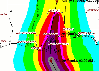
Most recent projected track from WU
Steve Gregory's most recent e-mail alert:
But here's a WAG on what I think MAY be happening with this storm. As discussed yesterday, there really has never been such an intense storm in the Atlantic region that has been able to maintain this type of intensity for very long. 24 hours is about the longest on record, and 12 hours is probably the average. EVERY storm I know of in which we have been able to observe eye wall replacement cycles has always gone through the process to some degree. It's now been 24 hours since the last cycle finished. And at the moment, satellite imagery and the RECON data shows that the eyewall is clearly expanding. It never was able to get lower than 20NM early this morning.
Last night I conjectured that we may have seen an eye wall replacement cycle start this evening, and if it went slowly, the storm would weaken some before making landfall. (This is in addition to the potential for some light wind shear impacting the system before landfall.) At the risk of hitting enter on this, only to see Katrina begin a real eye wall cycling begin, I am wondering if what we are going to actually see is a 'pulsation effect' where the exiting eye wall expands out to say 40NM, and then shrinks back down towards 20NM by morning. And because there are absolutely no other known environmental variable (except some light shear in the NW quadrant by morning....) this would result in some additional easing of winds during the next few hours, followed by an increase back up to as much as 175mph winds again by daybreak.
Other than that - the track remains unchanged, and the 18Z model runs continue to show landfall along the SE coast of LA with the eye passing over New Orleans. The 12Z model runs, and the 18Z runs, all have pegged the speed of the storm that matches current trends, and there is no way to determine the precise point of landfall. NHC has shifted their track a wee bit further west to match what I had 'relayed' to everyone earlier today. They have, however, adjusted the landfall intensity to be a high end CAT 4 at landfall, and most of the local NWS, with guidance from NHC, have eased back a bit on the max storm surge. Instead of 20-30 feet, many of the current local hydrological forecast are looking for 18-22 foot storm surge, with localized potential of 25 feet. All of which is still in the category of Hurricane Camille. Except, this storm is bigger than Camille!
The logical premise that the storm will in fact weaken a bit before landfall is a very high probability outcome - no doubt about it. But as I alluded to above, there is a chance that this storm could actually intensify late tonight but before morning. But even if my 'eye wall pulsation cycle theory' I just created out of thin air comes to pass - there still is the issue of increasing wind shear affecting the storm in the last 6 hours before land fall as the developing TROF in the central U.S. which led to Katrina's curve northward to begin with -- could simply over power the storms massive circulation just enough to weaken Katrina anyway. But given the immense size and intensity of this once per century type storm -- there may be 'no stopping' this storm -- since Super Storms, like Katrina, create their very own , self sustaining environment -- and can 'deflect' small outside influences - such light wind shear, or areas of dry air.
Personally, as a scientist who's lab is the world around him -- I would be exhilarated to see the 'pulsation cycle' unfold -- as long as we then get a lot of shear to weaken Katrina and prevent what may be the most catastrophic natural disaster in modern times for the U.S.
For a lot of reasons, I have chosen to make this Advisory the more 'detailed one' for he evening. From this point on through landfall -- I will only send out observational data and imagery. A more detailed analysis will only be provided if there is a significant change in the forecast. The next update will be around 9PM CDT
To those living in the area being impacted by this storm - my personal prayers are with you.
Steve Gregory
Wundergroud

