Updated: Ida has now officially returned to a Category 1 Hurricane. If you look at the forecast maps below it is expected to strengthen to Cat 2 before weakening due to wind shear in the Gulf before it makes US landfall.
Ida was a hurricane when it made landfall on Nov. 6th in Nicaragua and proceeded to dump up to 11 inches of rain along the coast resulting in flooding in many remote areas and destroying up to 80% of homes in places such as Sandy Bay Sirpe in eastern Nicaragua. Fortunately no deaths/injuries due to Ida have been reported. Ida dumped rain along the east coast of Nicaragua & Honduras and eventually weakened as hurricanes often do over land but survived and is now approaching the warm waters of the Western Caribbean.
Join me over the fold for forecast & graphics:
One of the best sites for detailed info (aside from official sites like the NHC) is of course Dr. Jeff Masters' Wunder Blog. Not only does he have lots of info but the commenters often post up to date radar pics, graphs etc for the weather geeks amongst us. According to his blog entry today:
The moderate wind shear of 15 - 20 knots should allow for continued slow but steady intensification of Ida through Sunday afternoon, as long as the center remains over water. I give Ida a medium (30 - 50% chance) of reaching Category 1 hurricane strength before arriving at the Yucatan, since the total heat content of the ocean in the Western Caribbean is so high.
And this has resulted in a Hurricane Warning being posted for parts of the Yucatan peninsula in Mexico.
Updated: Now a Hurricane Warning has been issued for part of the Yucatan Peninsula.
The NOAA public advisory from 1:15 AM CST:
000
WTNT31 KNHC 080711
TCPAT1
BULLETIN
HURRICANE IDA SPECIAL ADVISORY NUMBER 16
NWS TPC/NATIONAL HURRICANE CENTER MIAMI FL AL112009
115 AM CST SUN NOV 08 2009
...HURRICANE WARNING ISSUED FOR PART OF THE YUCATAN PENINSULA...
AT 115 AM CST...0715 UTC...THE GOVERNMENT OF MEXICO HAS ISSUED A
HURRICANE WARNING FROM PLAYA DEL CARMEN TO CABO CATOCHE. A
HURRICANE WARNING MEANS THAT HURRICANE CONDITIONS ARE EXPECTED
SOMEWHERE WITHIN THE WARNING AREA WITHIN 24 HOURS.
A HURRICANE WATCH REMAINS IN EFFECT FOR THE YUCATAN PENINSULA OF
MEXICO FROM TULUM TO PLAYA DEL CARMEN. A HURRICANE WATCH MEANS THAT
HURRICANE CONDITIONS ARE POSSIBLE WITHIN THE WATCH AREA...GENERALLY
WITHIN 36 HOURS.
A TROPICAL STORM WARNING REMAINS IN EFFECT FOR GRAND CAYMAN ISLAND.
A TROPICAL STORM WARNING REMAINS IN EFFECT FOR THE YUCATAN PENINSULA
OF MEXICO FROM PUNTA ALLEN NORTHWARD TO SAN FELIPE. A TROPICAL
STORM WARNING MEANS THAT TROPICAL STORM CONDITIONS ARE EXPECTED
WITHIN THE WARNING AREA...GENERALLY WITHIN 24 HOURS.
A TROPICAL STORM WARNING REMAINS IN EFFECT FOR THE CUBAN PROVINCE OF
PINAR DEL RIO.
A TROPICAL STORM WATCH REMAINS IN EFFECT FOR THE ISLE OF YOUTH.
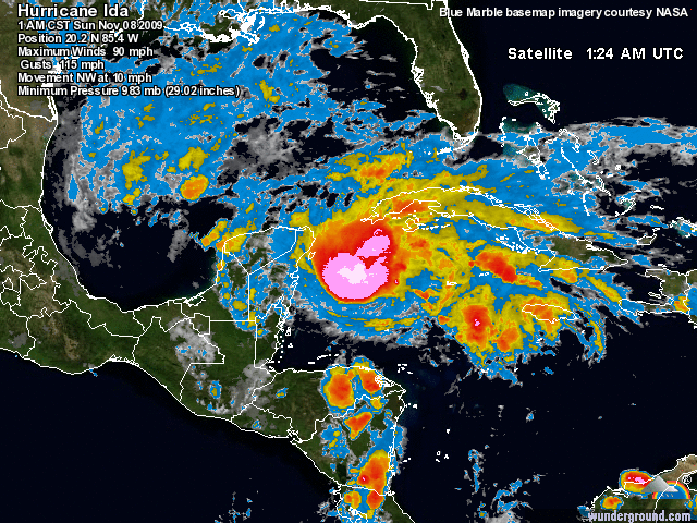
Here is a satellite loop of the storm.
This is the 5-day forecast for the storm. Note it looks to head right to the SE Gulf Coast.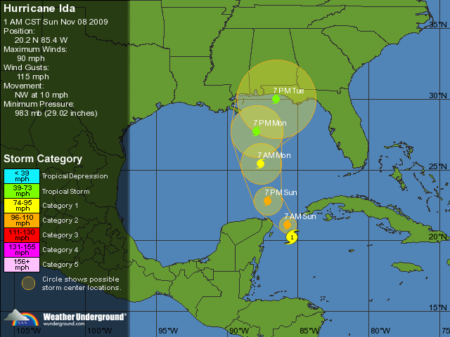
Dr. Masters says:
Once Ida crosses into the Gulf of Mexico on Sunday night, the storm will encounter much cooler SSTs and a strong trough of low pressure that will dump cold air into the storm and bring 40 knots of wind shear. This will cause Ida to lose its tropical characteristics and become a powerful extratropical storm with 45 - 55 mph winds. It is highly unlikely that Ida will hit the U.S. as a tropical storm, but it could still bring tropical storm-force winds of 45 mph to the coast next week as an extratropical storm.
So thankfully we are not looking at a strong hurricane but it still could pack a whallop for folks along the SE Gulf Coast. You can look at models, wind speed etc here and at the NOAA site as well here:Tropical Storm IDA
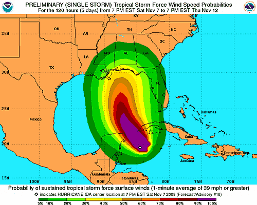
This is the updated NOAA Tropical Storm Force Wind Speed Probability map:
I know some of you are already battening down the hatches so to speak in those areas so feel free to add important info in the comments & I will do my best to update the diary as needed! Be safe!
