Burning petroleum (BP) and coal caused the warmest January through May surface temperatures on record. Despite El Nino, it should have been cool because 2008-2009 was the coolest solar minimum in 100 years. But Burning Petroleum (BP) [coal and natural gas] has consequences.
NASA GISS surface temperatures hit all time highs for the first 5 months of 2010.

Then comes the wind.
The Gulf's environmental problems go far Beyond Petroleum (BP) in places like the Dry Tortugas.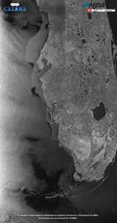
The sinking Mississippi delta, rising seas and warming oceans spell disaster for much of the Gulf.
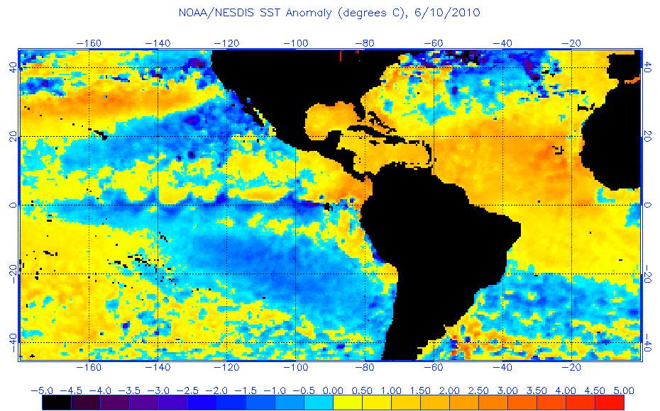
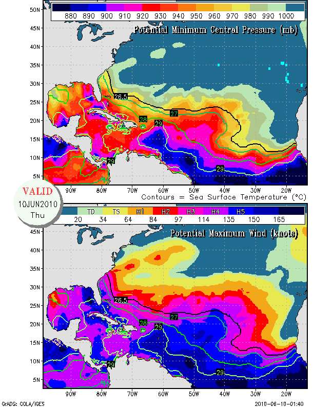
May sea surface temperatures in the main development region (MDR) for Atlantic basin hurricanes smashed all records. The MDR's water temperature was 1.5 Celsius - almost 3 degrees Fahrenheit - above normal.
May SSTs in the tropical Atlantic set a new record.
Sea Surface Temperatures (SSTs) in the Atlantic's Main Development Region for hurricanes had their warmest May on record, according to an analysis of historical SST data from the UK Hadley Center. SST data goes back to 1850, though there is much missing data before 1910 and during WWI and WWII. SSTs in the Main Development Region (10°N to 20°N and 20°W to 80°W) were a remarkable 1.51°C above average during May. This is the fourth straight record warm month, and the warmest anomaly measured for any month. The previous record warmest anomaly for the Atlantic MDR was 1.46°C, set last month. Third place goes to June 2005 and March 2010, with a 1.26°C anomaly
NOAA nightime SST anomalies show cool water on the equator in the eastern Pacific (El Nino is over) and record warm water temperatures in the tropical Atlantic.
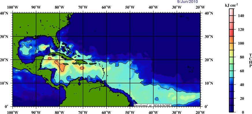
Analysis by NOAA's Atlantic Oceanographic and Meteorological Lab (AOML) show that the heat content of the upper Atlantic ocean in the main development region is higher at this date in 2010 than the this date in the record Atlantic hurricane year of 2005.
Tropical Atlantic heat content June 9, 2010
Tropical Atlantic heat content June 9, 2005
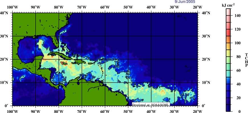
Most of the tropical Atlantic basin has warm enough water to support major hurricanes today.
Wind shear, the factor that rips tropical waves apart before they can become hurricanes has weakened across the Atlantic's MDR. By July, the first month that intense hurricanes form in the Atlantic, westerly winds aloft that cause wind shear will retreat further north. Because El Nino, which generates westerly winds in the tropical Atlantic, is over, wind shear is likely to be low by July. Record warm water temperatures and low wind shear in the tropical Atlantic basin provide ideal conditions for tropical storm development.
Wind shear in the tropical Atlantic has decreased. Tropical storm development is now possible in the MDR.

Three different respected organizations are making their strongest forecasts ever for Atlantic basin hurricanes.
The British private forecasting firm Tropical Storm Risk, Inc. (TSR) has joined the ranks of NOAA and Colorado State University in calling for an exceptionally active 2010 Atlantic hurricane season. The latest TSR forecast issued June 4 calls for 17.7 named storms, 9.5 hurricanes, 4.4 intense hurricanes, and an Accumulated Cyclone Energy (ACE) 181% of average. These numbers are much above the 50-year average of 10 named storms, 6 hurricanes, and 2 intense hurricanes, and are an increase from their April forecast of 16.3 named storms, 8.5 hurricanes, and 4 intense hurricanes. The TSR June forecast numbers are the highest they've ever gone for in the eleven years they've been issuing Atlantic hurricane season forecasts.
2010 hurricane season forecasts from CSU and NOAA
NOAA's 2010 Atlantic hurricane season forecast, issued May 27, called for 18.5 named storms, 11 hurricanes, 5 major hurricanes, and an ACE index 210% of normal (using the mid-point of their range of numbers.) The 2010 Atlantic hurricane season forecast from Colorado State University (CSU) issued on June 2 called for 18 named storms, 10 hurricanes, and 5 intense hurricanes. So, the consensus forecast from NOAA, CSU, and TSR is 18 named storms, 10 hurricanes, and 5 intense hurricanes. The June forecast numbers from all three groups were the highest they've ever gone for in their history of issuinhttp://www.dailykos.com/story/2010/6/10/195944/451g Atlantic hurricane season forecasts.
The BP Gulf oil gusher is a disaster. The effects of climate change will be far worse.
June 9, 2010 MODIS Terra satellite true color image shows silvery oil slick.

A bright silvery oil slick extends from the Deepwater Horizon drill site to Mississippi 's Gulf coast. A large dark mass of what may be oxidized weathered oil lurks off of the coast of Texas.
