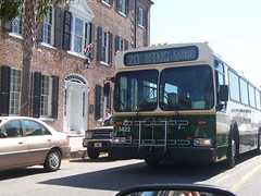
Mount Pleasant, SC- We’re going to begin an attempt to crowd source performance data on the new #401 East Cooper Connector Route today as an interim approach to providing real time location data on our new neighborhood bus.
 Ultimately, we hope to install a GPS beacon on the bus which will give users direct, real time access to the location of the bus.
A temporary experiment doing this was deployed downtown on a DASH bus by City Slicker last winter.
We're East Cooper CARTA Riders, an independent riders advocacy group: www.eastccrider.com.
It appears we can have such a system up and running on the #401 for an entire year for less than Two Hundred and Fifty Dollars ($250.00). See the Amazon website for more information: http://www.amazon.com/...
We’ll need to get such a project funded and approved.
However until such a device can be paid for and deployed, we need some way to monitor the bus now. Starting today, East Cooper CARTA Riders is developing a spotter network which will use twitter hashtags to update people on the location of the #401.
Just post the location of the #401 and the time it was observed with the hashtag #carta401 on twitter. We’re began building the spotter network today. Boulevard Diner on Coleman Blvd. is the first participant. We’ve asked them to report the time the bus passes their business going East. Since they’re not familiar with twitter, they’re going to call their reports in to (843) 870-5299. I’ll tweet those reports out and any others received from our @eastccrider twitter presence.
I can't expect everyone at the Boulevard Diner to stop making omelets to watch for the bus every hour, so we'll need a lot of spotters using twitter to make this work. If it does, we'll be able to know where the bus is, at least some of the time, by searching for #carta401 on twitter from our smart phones.
That should result in better on time and on route performance which will benefit the people riding who don't have smart phones. Of course if there is a crowd of people at a stop, whoever has an internet capable phone can share the information with others. Then everyone will be ready and stop time should be reduced at least some of the time.
I got this idea from the way people in Cairo tracked tanks during the revolution three months ago. They used this exact method so that the community on Tahir square knew what the Egyptian army was doing by tweeting the location and time where the tanks were observed. Street vendors and shop owners helped. The army, foolishly had a number painted on each tank. The tech camp on the square mapped the data to the internet and everyone knew what the army was doing in real time.
If Twitter can overturn a corrupt government with tanks in Egypt, maybe it can let people in Mt. Pleasant know when the #401 bus is coming.
Thanks for reading. Transit is a journey we make together. Starting now, lets make it a smarter, more reliable trip.
