Massachusetts redistricting is well under way. The Legislative Committee on Redistricting has concluded its round of public hearings and is now scheduled to begin drawing maps over the next couple of months. In the spirit of Common Cause Massachusetts's Redistricting Olympics, I thought that it was appropriate to produce some of my own maps. I have started with the Congressional map.
These attempts prioritize several considerations while generally neglecting others.
First, these maps insisted on creating one majority-minority district while generally preserving the city of Boston. Second, these map insisted on maintaining two districts west of highway 495. And third, this map attempted to promote communities of interest above all else. In general, very few towns are split between multiple districts.
These maps did not take into consideration incumbency or which current House members will run against each other. Several districts did remain generally intact (D-3: Tsongas, D-4: Tierney, D-7: Keating). However, that is due to following the considerations above, not intentionally preserving their seats.
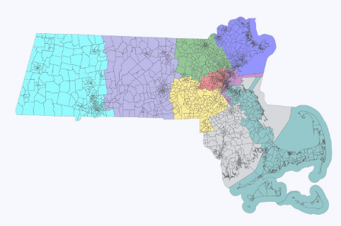
And so without further ado, I present you the Massachusetts Congressional Map:
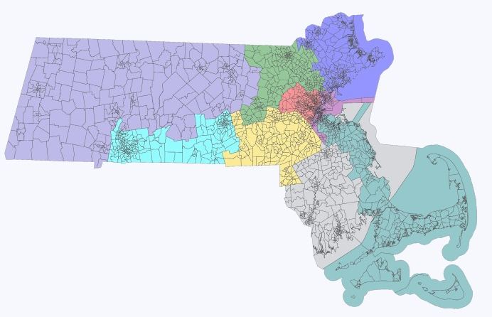
After publishing this first attempt I have tried to incorporate comment critique into a different map while still abiding by the three considerations above. This map is not finished (I need to decide which towns to split in order to fulfill the equal population requirement. The Lowell district is currently 9,000 people too large with others hovering plus or minus 2,000 from the ideal. The revised Congressional map:
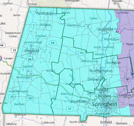
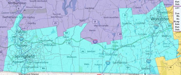
MA-01: Western District
In order to maintain two Western MA dominated districts, one district needs to be anchored by Springfield and one by Worcester. This first district is anchored by Springfield and surrounding satellite towns. MA-01 is compact and preserves Western MA unity.
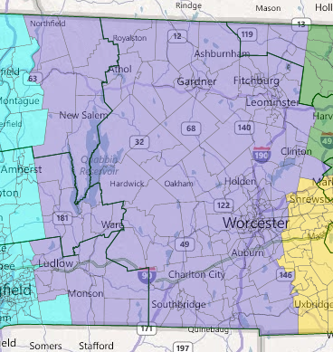
MA-02: Worcester County District
MA-02 is the other Western district that also picks up some of central MA. Following the shape of MA-01 it is also highly compact given its large geographical size. Its main anchor town is Worcester.
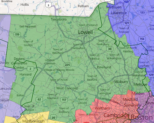
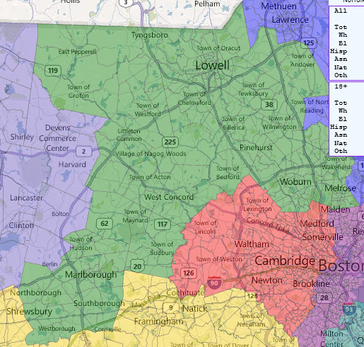
MA-03: Lowell District
MA-03 is largely Tsongas's MA-05 district in the current map. Again this district is compact and preserves the communities of interest in the central North portion of the state.
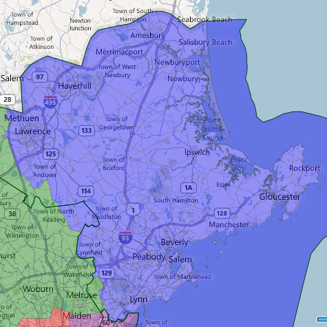
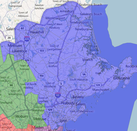
MA-04: Essex County District
Again MA-04 is quite similar to Tierney's current MA-06. The population of this region is roughly ideal in size and homogeneity for a district and I see no reason for splitting it up.
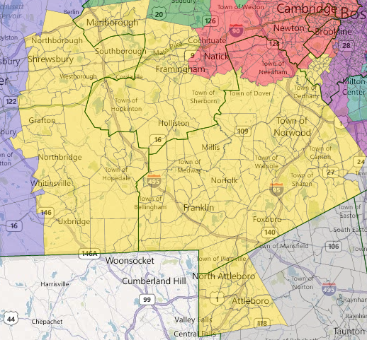
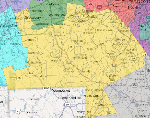
MA-05: Central District
This is my least favorite district and unfortunately ends up being somewhat of the scraps after drawing the others. However, I think the communities of interest are still fairly strong in this area and it is compact except for the addition of the Attleboro region which had to be included to satisfy equal population requirements.
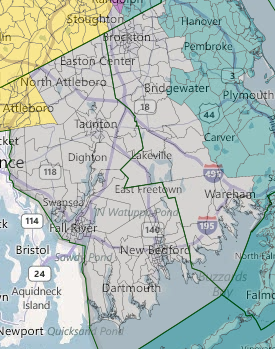
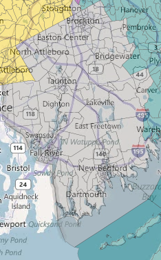
MA-06: Fall River/New Bedford District
MA-06 replaces Barney Frank's current heavily gerrymandered MA-04. This district keeps in tact the Fall River and New Bedford areas and then proceeds North to pick up more population. This district is highly compact and makes a lot more sense then the current district.
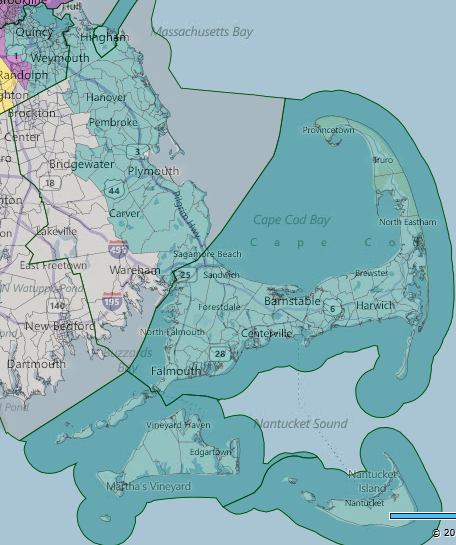
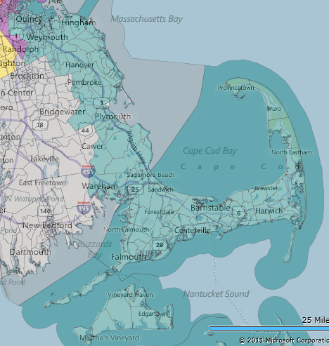
MA-07: Cape/South Shore District
This district is almost identical to Keatings current district. In terms of preserving communities of interest I think that it makes sense to include the South Shore with the Cape and Nantucket. I did originally want to cut Quincy from this district but other considerations (mainly the Boston district) prevented me from doing such.
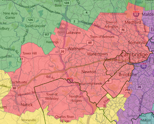
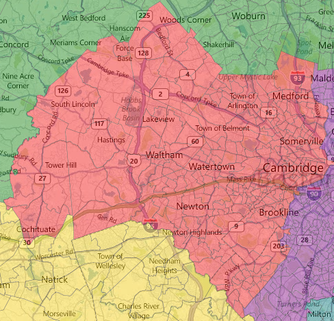
MA-08: Metro West District
Rather than carving up this area into multiple districts as the current maps does I thought that it made more sense to bring all of the Boston suburbs into one unified district. MA-08 begins with Somerville, Cambridge, and Brookling and then moves West along I-90 picking up Newton, Watertown and Waltham.
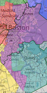
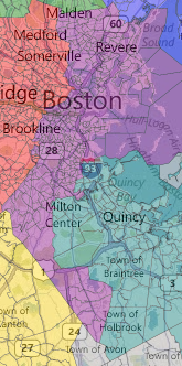
MA-09: Boston District
This district began it all. I purposely started with Boston so that I could create a reasonable majority-minority district while at the same time keeping Boston mostly intact. In order to do this I had to sacrifice compactness by going all the way down to Randolph and up into Everett to pick up more minority votes. I believe I accomplished that, although by only a small margin. MA-09 is 50.7% non-white just barely making it majority-minority.
*******
SECOND TRY
*******
MA-01: Western District
One of the biggest changes from the original map. After hearing some concerns about the vertical approach to Western MA I decided to go for more of the horizontal approach that currently exists. This Western district is truly a Western district and comprises of all rural area.

MA-02: Worcester/Springfield District
In order to unite all of rural Western MA there had to be a union of Springfield and Worcester which arguably makes a lot of sense as both are large cities west of 495. The only down fall is having to include the area between the two cities which will be largely silenced by these two large competing interests.
MA-03: Lowell District
This district remains largely the same with several differences. It dropped a few precincts in Methuen and North Reading but picked up all of Andover in the North and Marlborough, Westborough, Northborough, Southborough in the Southwest corner.
MA-04: Essex County District
Remains largely the same except addition of North Reading and loss of Andover.
MA-05: Central District
Loses the Borough towns to the Lowell district but picks up Natick to unite with Framingham.
MA-06: Fall River/New Bedford District
Picks up several small towns (Halifax, Carver) on the eastern coast but loses Wareham.
MA-07: Cape/South Shore District
Gains Wareham while losing several of its smaller towns on the western coast.
MA-08: Metro West District
Loses Natick and Needham. Picks up Lexington, Roslindale and West Roxbury to unite the Metro West area.
MA-09: Boston District
A few minor changes but remains majority-minority actually increasing minority VAP to a whopping 50.9%
And so that wraps up Massachusetts's nine new Congressional Districts.
As a recent dailykoser also found, the map that emphasizes communities of interest over incumbency results in a map that is highly favorable to three current Reps. with the least likelihood of keeping their seats (Tsongas, Tierney, and Keating). Some of the more senior members find themselves with very different looking districts.
Please continue to comment. I still need to solve the equal population requirement problem. I would love to hear what you think and if others have found better ways of draw a map that abides by the principles laid out above.
Also do not forget that Common Cause Massachusetts is hosting their Redistricting Olympics until August 30. Get your maps in sooner rather than later.
