We will begin with the Senator. The Weather/Dam info has been updated from last nights diary.
Senator Ben Nelson is stressed about the two nuclear plants in his State of Nebraska. Dam Report.
THE LETTER
In a letter today, Senator Ben Nelson expressed his concern regarding a statement made by a representative of the US Army Corp of Engineers in charge of the Missouri River flooding, specifically the Corps stated
"Nebraska's two nuclear plants aren't being factored into the Army Corps of Engineers schedule of dam releases." He went on to say, "Flood-risk reduction is our priority right now. We are working closely with OPPD and NPPD, so I would never say that we wouldn't consider adjusting releases, but I can't imagine all the possible scenarios. Currently, there is just no flexibility in the system."
Senator Nelson responds with
"General, given the heightened state of concern from the public at large regarding the flood's impact on Nebraska's two nuclear facilities, I am certain you are appreciative of the trepidation arising from the above comments by the Corps"
I also wish to learn more as to what steps the Corps is taking in conjunction with the NRC, OPPD, and NPPD to ensure the structural integrity of the structures protecting the Fort Calhoun and Cooper Nuclear Stations.
Here's the latest video of Ft. Calhoun Nuclear Plant:
But what can the Corps do to prioritize the water level abatement at the nuclear plants?
That is what Senator Nelson would like to know. In his letter he asks for additional concern for the nuclear plants
Given our discussion last week on the Corps' responsibility to protect the people, communities, and infrastructure along the Missouri River, additional concern and caution would seem necessary in addressing the two nuclear facilities.
THE ARMY CORPS OF ENGINEERS CHALLENGE
The present flood stage management hinges on one thing: NO more HEAVY RAIN
Protecting the integrity of the dams has to be a first priority because, if an upstream dam were to fail, that would surely jeopardize the water levels at the nuclear plants as well. This sometimes leaves the Corp with the hard choice between one plan that will cause harm to some and/or another plan that will cause harm to others.
As of June 3rd
The U.S. Army Corp of Engineers remains focused on increasing water flows on the Missouri river. The plan is to reach 150 - thousand cubic feet per second by mid-June.... is the first time in history that that much water has passed through the four dams in South Dakota.
And they have done so. This all the information I could find in an understandable format. The source copied it from somewhere, but didn't offer a link. If you can find a better source, let me know asap. Thanks. As of today, there are not a lot of wiggle room.
NEW
Missouri River Dam flow information for June 30, 2011
(preceeding 24 hour period)
Fort Peck.......: Inflow.. 44,000; Outflow 51,000; ..Flow held back ..... N/A
Fort Garrison...: Inflow 151,000; Outflow 145,000; Flow held back ...6,000
Oahe.............: Inflow 157,000; Outflow 150,000; Flow held back ....7,000+-
Big Bend ........: Inflow 152,000; Outflow 154,000; Flow held back ......N/A
Fort Randall.....: Inflow 168,000; Outflow 155,000; Flow held back ...13,000 +-
Gavins Point....: Inflow 159,000; Outflow 160,000; Flow held back .......N/A
Total Flow Held Back last 24 hours = 26,000 cf/s
Dam Reservoir storage information as of June 30, 2011:
(new category: Acre Feet of storage capacity remaining in impoundment to 100% FC level)
Fort Peck.....: Flood Control max level ... 2250 : current level ... 2250.8 : FC storage 106% : Acre Ft avail -0-
Garrison.......: Flood Control max level ... 1854 : current level ... 1854.4 : FC storage 102% : Acre Ft avail -0-
Oahe...........: Flood Control max level ... 1620 : current level ... 1619.6 : FC storage. 96% : Acre Ft avail 181,000
Big Bend.......: Flood Control max level ... 1423 : current level ... 1420.1 : FC storage.. 2% : Acre Ft avail 174,000
Fort Randal...: Flood Control max level ... 1375 : current level ... 1373.4 : FC Storage. 93% : Acre Ft avail 170,000 (Fort Randal pool level increase .3 feet over the preceeding 24 hours)
Gavins Point..: Flood Control max level ... 1210 : current level ... 1206.1 : FC Storage. 26% : Acre Ft avail 105,000
Acre feet of storage available June 29 was 826,000
Acre feet of storage available June 30 is.. 630,000
(note: When viewed through the prism of remaining available storage the problem is NOT getting any better but is in fact getting worse. New rain in the watershed will only aggrevate the problem)
THE GOOD NEWS
The good news at Fort Calhoun nuclear plant is that they are safe from flooding the nuclear reactor unless water levels rise another 8 feet which is unlikely. The spent fuel pond is even safer from flooding. As long as the cooling systems remain operational at Calhoun and Cooper nuclear plants, the public is safe from radiation releases.
FLOODING
Accounting for the present mass of water, including the snow melt, upstream from the nuclear plants, the Corps reports
As of June 16, 2011
Because of the extraordinary volume of water, Browning anticipates that the overflow discharge will continue through August, which means that the base level of the river will stay about 3 feet over flood stage throughout the summer.
From the same article on June 16, 2011
Predictions are based on current water flow and include only the next 24 hours of precipitation forecast, he said.
"What happens ultimately depends not only on the amount of rain but also how it falls," he said. "It's more problematic if it falls in a concentrated period rather than extended over time."
THE BAD NEWS
So, what happens? It rains day in and day out ever since.
It rains in Western Montana over the Fort Peck Dam. It rains in North Dakota over the Garrison Dam. It rains in South Dakota over its dams. And it rains and rains and rains almost daily over the rivers flowing into the Missouri River from all sides and north of the Nebraska nuclear plants. In Nebraska itself, it also just keeps raining.
It's raining right now over the Fort Peck Dam and in Nebraska. Click on this link to view the radar weather in Western Montana and Nebraska
http://www.wunderground.com/...
And this is why I raise concerns, and I would not be surprised if this is why Senator Nelson is also concerned, and maybe why the Corps representative told the truth in his statement quoted in the introduction.
Again he stated:
"Currently, there is just no flexibility in the system."
So the true reality regarding the safety of Fort Calhoun and Cooper nuclear plants rests on the shoulders of the brave men and women fighting a mighty battle to keep these plants dry and their reactors and spent fuel ponds cool and full of water regardless of what happens to the river.
It was said best by
NRC Chairman Gregory Jaczko had solemn words for the staff of Fort Calhoun after touring the plant on Monday.
"In the end," Jaczko said, "this challenge is yours."
Call it fear mongering, whatever, the fact on the ground is that it has rained ever since the June 16th Corps appraisal of the situation. That we haven't had higher water levels at the nuclear plants is a testament to the Corp and all the others involved in calculating and controlling the flow of waters into the Missouri River and through the dams to date.
THE NEVERENDING RAIN
I will share that I have been watching the weather in general since April, alarmed by the tornado-laden storms that caused the deaths of 300+ people on April 27th.
I have also watched the weather affecting the dams very closely because of record snow falls this year.
The following are screen shots taken of the weather in the areas that are critical to controlling the flooding of the Missouri River:
Montana, North Dakota, South Dakota, Nebraska, and the areas that feed run off into the Missouri
since the June 16th statement by the Corps of Engineers. I can only imagine their alarm and frustration due to what seems like the neverending rain. These are just a few pics of the weather since June 16th.. Not all days are represented.
I looked and couldn't find the rainfall archives from NOAA. But here is the precipitation archive that is complete through April, 2011. At a glance, it doesn't look that foreboding. Scratching my head. But it is a record.
http://www.cpc.ncep.noaa.gov/...
NOAA Severe Weather reports are archived and can be viewed from June 16th - Today. However, these are just the severe storms. Tornadoes, hail, and high winds. You will see that the areas feeding the Missouri have had more than their share.
WEATHER REPORT June 12, 2011 to Present
I will begin with the reports I recorded on youtube for the days June 12, 2011 then I will place a link to the NOAA Severe Weather Report above the youtube recording of the day. This way you can get a good idea of just how severe the weather has been, day after day.
NOAA Severe Storm ReportJune 12, 2011
http://www.spc.noaa.gov/...
NOAA Severe Weather Report
http://www.spc.noaa.gov/...
June 13, 2011 Almost identical repeat of the weather on June 12, 2011.
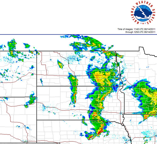
NOAA Severe Weather Report June 14, 2011 (no video for this day)
http://www.spc.noaa.gov/...
NOAA Severe Weather Report June 15, 2011
http://www.spc.noaa.gov/...
Midnight, go to minute 5:00 to see similar storms in the Dakotas
NOAA Severe Weather Report for June 16th
http://www.spc.noaa.gov/...
NOAA Severe Weather Report for June 17th
http://www.spc.noaa.gov/...
June 16 and 17 Peck and Garrison Dams are still getting rain. Go to minute 5:18
NOAA Severe Weather Report for June 18th
http://www.spc.noaa.gov/...
June 18, 2011 Peck and Garrison rain, go to minute 6:42
Prediction for Severe Weather for June 19, 2011 Dakotas and Nebraska, 1st 2 minutes
NOAA Severe Weather Report for June 19th
http://www.spc.noaa.gov/...
And the prediction was accurate. Weather on June 19th in Missouri flood areas. Go to minute 1:11
NOAA Severe Weather Report for June 20th
http://www.spc.noaa.gov/...
June 20, 2011 Huge storm system over Dakotas and Nebraska, go to minute 4:07
NOAA Severe Weather Report for June 21st, A day without severe weather in the Missouri run off areas, but rain nonetheless in Nebraska
http://www.spc.noaa.gov/...
June 21, 2011 Go to minute 6:46 to see the Nebraska Dakota storm
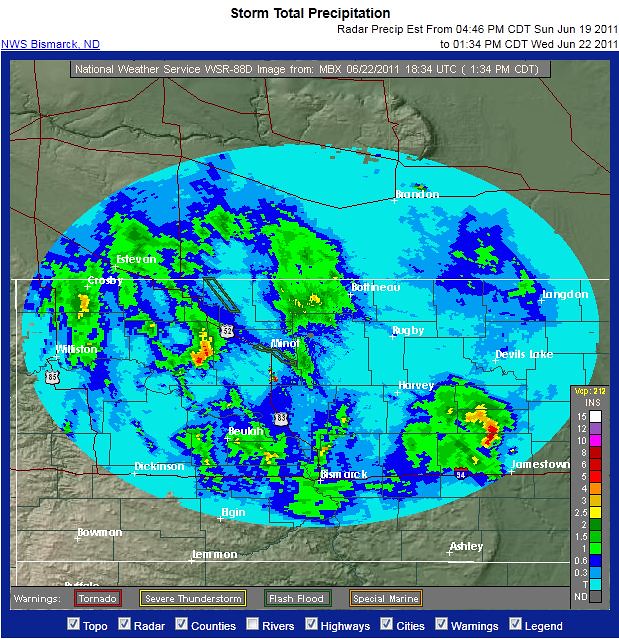
NOAA Severe Weather Report for June 22nd,
http://www.spc.noaa.gov/...
Rain in North Dakota
NOAA Severe Weather Report for June 23rd,
http://www.spc.noaa.gov/...
June 23 and June 24 More Rain Both days. Montana storms near Fort Peck Dam
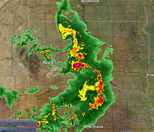
NOAA Severe Weather Report for June 24th
http://www.spc.noaa.gov/...
June 24, 2011 Storms
NOAA Severe Weather Report for June 25th
http://www.spc.noaa.gov/...

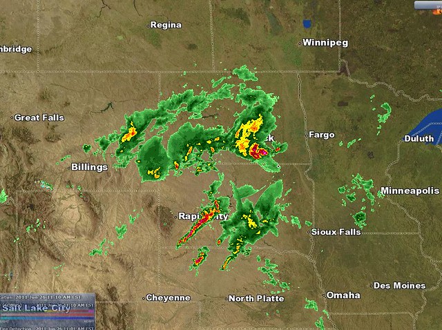
NOAA Severe Weather Report for June 26th, a very bad day for Nebraska
http://www.spc.noaa.gov/...
June 26, 2011 Storms Nebraska
Fort Peck, Montana
Garrison Dam, North Dakota
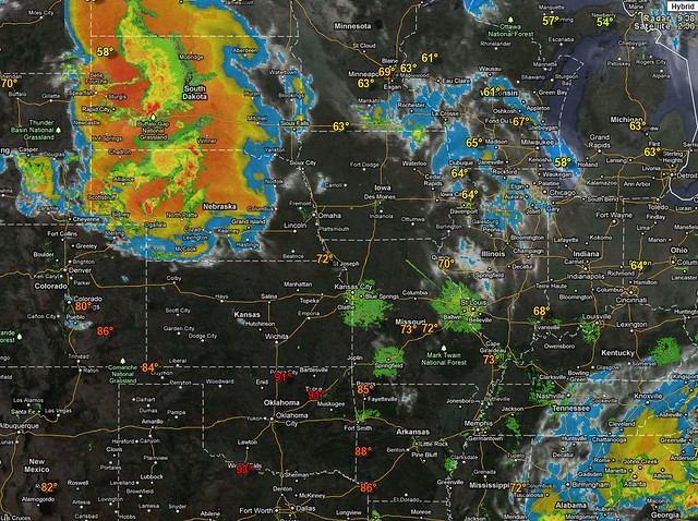
NOAA Severe Weather Report for June 27th
http://www.spc.noaa.gov/...
We have a recording of huge weather outbreaks in Nebraska on the 27th!
June 27, 2011 Still storming in Nebraska, even a tornado warning.
June 28th, a reprieve
http://www.spc.noaa.gov/...
June 29th, Western Montana above the Fort Peck Dam, rain Dakotas
http://www.spc.noaa.gov/...
And today, June 30th, Montana and the Peck Dam area got soaked again!
NEW 6/30/2011 PM More rain North Central Nebraska, the Dakotas, Eastern Wyoming.
NEW July 1, 2011 AM Weather/Dam Report
This is why I have great concern for the safety of the nuclear plants.
THE DAMS STATUS,
The status of water flow from each dam ispresented below in the order they descend along the Missouri River tributary system from Fort Peck, Garrison, and so on down the line.
Here's a picture of the dams and their proximity to the two nuclear plants in Nebraska:

On June 10th, at the Fort Peck Dam
water to flow through at 47,000 cubic feet per second (CFS), for a record 60,000 CFS flow rate through the powerhouse and spillway on the upper portion of the Missouri River, moving a record amount of rain down the river system.
On June 9th at the Garrison Dam
Releases will be increased Monday to 85,000 cubic feet per second.
Corps project manager Todd Linquist says the plan is to hold releases at that level until about June 9. Then releases will be bumped up to 105,000 cfs. The increase is necessary because of snow melt water coming into the Missouri River System.
Linquist wouldn't rule out higher releases and says Bismarck will prepare defenses even higher. "We are planning to coordinate with the cities to design our protective measures to a flow of 120,000 cfs.
June 19, 2011 at the Oahe Dam
Oahe Dam Increases Release to 1.2 Million Gallons Per Second
Even as the water creeps closer and closer to homes, the source of the water draws people to the dam.
No more increases are scheduled for the Oahe Dam, but as all these residents already know, that could change again.
June 17, 2011 at the Big Bend Dam
Discharges from Oahe and Big Bend dams will increase beyond the projected maximum of 150,000 cubic feet a second to make room for heavy rain expected this weekend, but officials said it will not affect releases from Gavins Point Dam.
But there is a problem now at Big Bend.
Fort Thompson, S. D.—The U.S. Army Corps of Engineers will inspect the spillway structure at Big Bend Dam July 1. Spillway gates will close so that personnel can inspect the concrete apron, wing walls and dissipation pillars via boat.
This is a more detailed analysis of the problem can be viewed by clicking this link.
In other words, the Army is concerned about erosion backward toward the dam (known as back-cutting).
If the back-cutting requires the closure of the spillway for any length of time, the Army will have to increase the water discharge rates through the dam’s tunnels to compensate. Big Bend Dam cannot just shut down on the Missouri. Since the reservoir behind the dam is small and was not built as a flood control reservoir, it cannot long store the high flows coming down from Oahe Dam. As a result, Oahe Dam would have to cut back on its discharge rates. But Oahe is almost full, so it cannot pull back on its outflows for long. Oahe will have to let water go eventually. If Big Bend Dam cannot release enough water through its tunnels, where will it go and how will it be evacuated through the dam without an operational spillway?
June 23, 2011 at the Fort Randall Dam
The Army Corps of Engineers is using four flood release tunnels to move water at the Fort Randall Dam.
The Corps began releasing water at 10 o'clock Thursday morning. Water is flowing through the 26-foot diameter pipes while equipment is being removed from the emergency spillway. Once that is done, extra releases from the dam will go back through the spillway.
The Corps says the recent repair work at the dam was routine and is not related to the high flows.
June 25, 2011 at the Gavin Dam
This is the dam keeping the floodwaters back from the two nuclear power plants. The Gavin Dam is holding back a lot of water. The Gavin Dam link above tells quite a story and I would encourage you to read the history of the area and the Randal and Gavin Dams.
From the site, the following is from "Notes from the field, June 14"
Today, the Army increased the volume of water released through the emergency spillway at Gavin’s Point Dam to 150,000 cfs. Gavin’s Point Dam is the southernmost of the Army dams across the Missouri.
Then there is the rain. Sioux City has received almost an inch of precipitation in the past two days. Points to the north and northwest of that city have received even more rainfall. The rain has no where to go, so it remains in the fields. The forecast for southeastern South Dakota, northwestern Iowa, and northeastern Nebraska, calls for a chance of rain in six of the next seven days.
Lewis And Clark Lake, South Dakota
Lewis and Clark Lake is the result of Gavins Point Dam on the Missouri River in Yankton County, South Dakota and is used for flood control, hydroelectric power, irrigation, improved navigation and recreation purposes. Construction was completed in 1958. It has a normal surface area of 50 square miles. It is owned by the U.S. Army Corps of Engineers.
Gavins Point Dam, also known as Lewis And Clark Lake is of earthen construction.
The core is earth.
The foundation is rock, soil.
Its length is 8,700 feet.
Maximum discharge is 584,000 cubic feet per second. (It's presently releasing 150,000 cfs, see above)
Its capacity is 540,000 acre feet.
Normal storage is 375,000 acre feet.
It drains an area of 16,000 square miles.
And that is just behind the Gavin Point Dam. There are millions of acre feet upstream.
IN CONCLUSION:
We have a very serious situation in Nebraska and throughout the Missouri River spillways. To down play this situation is irresponsible.
Alert your friends and monitor the situation closely.
The Notes from the Field series is a great way to get the information from a professional that is otherwise unavailable, imo.
I highly recommend the videos at this site:
http://www.youtube.com/...
It is important to note that the areas leading into the Missouri River are already flooded and many levees have already been breached or knocked down by the Corp.
Stay safe.

