Times zones seem like they should be pretty straight forward. Since a day—the time from one sunrise to the next—is generally accepted to contain 24 hours, it would seem to make sense to divide the world into 24 time zones with each time zone being one hour earlier or later than its adjacent time zones. So far, that sounds like a simple task.
Next, we have to take into consideration that the earth is basically round. For more than 2,600 years geographers have been describing the earth as a globe. In sixth century BCE, Anaximander, the Greek founder of scientific geography, had proposed the symmetry of the terrestrial globe, dividing it into four hemispheres surrounded by water.
It should be pointed out that there were heated arguments by some 19th century anti-science types who argued that the Bible says that the earth is flat and therefore science must be wrong. They also argued that gravity is simply a theory and is contrary to Biblical teachings. They felt that those who believed the world to be round and that gravity exists cannot be Christian. In spite of their arguments, just about everyone today admits that the world is round.
As a historical footnote, it should be pointed out that one of the first people to propose the idea of dividing the world into 24 time zones was the Italian mathematician Quirico Filopanti. In a work published in 1858, he proposed longitudinal days based on a meridian centered on Rome. His work was basically ignored and in 1879 the Canadian Sir Sanford Fleming proposed a worldwide system of times and is thus often credited with the invention of time zones. He proposed using a meridian passing through Greenwich, England.
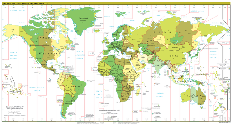
To divide the world into 24 time zones, one simply has to draw 24 imaginary lines, through the poles, around the world. Now the problem is determining the starting point. There is no obvious starting point, so this initial line is not only arbitrary, but also based on lots of political arguing. At the present time, most people (but not all) have accepted an imaginary line through Greenwich, England as the starting point. Now with this in mind, there has to be a place where there is a difference in days, somewhere where the day truly starts on the planet. Again, there has been an arbitrary solution: exactly half-way around the planet from Greenwich at 180° longitude is the International Date Line. Cross the line from the east to the west and a day is added. Cross from west to the east and a day is subtracted.
While it would be nice if the International Date Line was a straight line, political considerations have created some interesting zigzags. Going through the Bering Strait between Alaska and Russia, the line bends to avoid placing far northeastern Russia in a different day than the rest of the country.
One of the reasons for placing the International Date Line at 180° longitude is that means that the line cuts through the Pacific Ocean and doesn’t interrupt a lot of land-based nations. However, the line split the small island nation of Kiribati. In 1995 Kiribati unilaterally decided to move the International Date Line. Since the line is simply established by international agreement and there are not treaties or formal agreements associated with the line, most of the rest of the world simply followed Kiribati and moved the line on their maps. Moving the line meant that Kiribati is all within the same day. Eastern Kiribati and Hawaii, which are located in the same area of longitude, are a whole day apart.
Now the other 23 imaginary lines that divide the world into one-hour time zones have lots of zigs and zags brought about for political reasons. To confuse the issue, there are also offset time zones: these time zones are offset by a half-hour or even fifteen minutes off of the standard twenty four time zones of the world.
The second most populous country in the world is India. With regard to time zones, India is a half-hour ahead of Pakistan to the west and a half-hour behind Bangladesh to the east.
Iran, a country well-known today for being a little out of step with the rest of the world, is a half-hour ahead of Iran to the west. On the other hand, it is an hour behind Afghanistan to the east, and Afghanistan is a half-hour behind its neighboring countries of Turkmenistan and Pakistan.
Australia is a huge country. Its Northern Territory and South Australia are offset in the Australian Central Standard Time zone: they are a half-hour behind the east (Australian Eastern Standard Time) but they are an hour and a half ahead of the state of Western Australia (Australian Western Standard Time).
The Newfoundland Standard Time Zone (NST) which covers much of Newfoundland and Labrador in Canada is a half-hour ahead of the Atlantic Standard Time (AST). The island of Newfoundland and southeastern Labrador are in NST while the remainder of Labrador along with neighboring provinces New Brunswick, Prince Edward Island, and Nova Scotia lie in AST.
In 2007, President Hugo Chavez established Venezuela as an offset time zone: it is a half-hour earlier than Guyana to the east and a half-hour later than Colombia to the west.
Nepal is fifteen minutes behind the standard time zone of its neighbors.
