Prologue: Yesterday's Arches NP tour (http://www.dailykos.com/...) mentioned hikes ranging from the easy to the more strenuous. Its diary would not be complete without a more descriptive account of at least two hikes in the park that will appeal to those who not only enjoy hiking, but also are willing to go up against a formidable challenge when Nature's thermostat cranks during the warmer months. Then again, most people visiting this stunning national park tend to arrive during this period. The best advice in such conditions is to hike early. There's another saying I often passed along to my charges when conducting tours in such places: Lose sleep, beat the heat! Ergo, hiking early to me entails leaving well before that great big fusion ball in the sky gets high and hot enough to burn one's eyeballs and tap precious bodily moisture to the extent the physical and mental states begin to corrupt.
And, heck yes, this graphic account is necessary to point out, because in desert terrain, and when the heat is high, some people just don't get the point of hiking smart. In this supplemental diary, I will pass along the wisdom of the ages and experience that comprehends potential peril. There is also a Norwegian adage that applies: There's no such thing as bad weather, just bad clothing. In other words, dressing for the climate, but also taking precautionary steps that gives the hiker an edge.
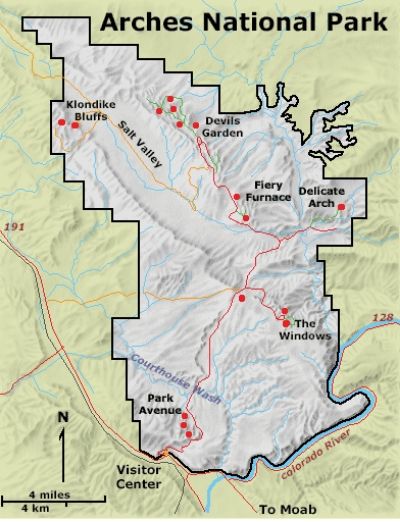
The two hikes I have prepared for this diary are the following:
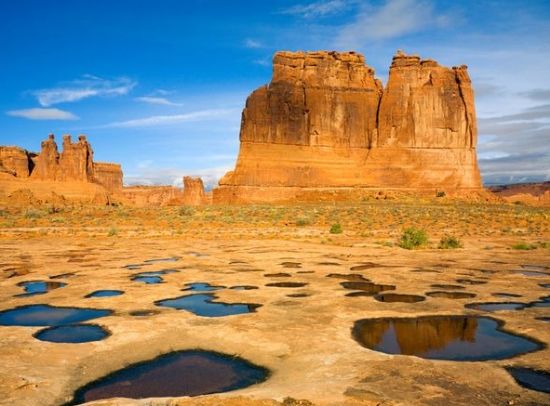
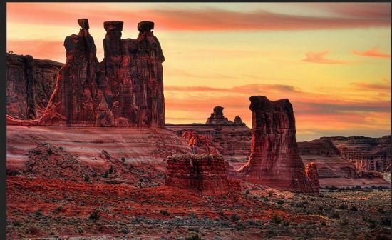
and this winsome-looking locale. . .

(Continues after the fold.)
 np sign
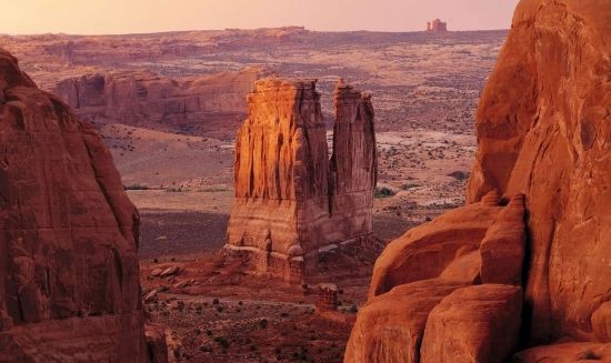
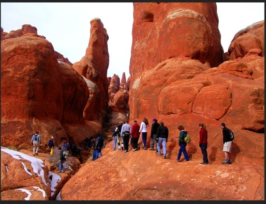
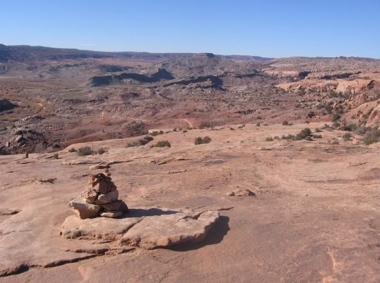
Of course, sometimes, and depending on the season and time of day, there might be a bit of a crowd hiking to some place or another. . .
Then again, sometimes there is so much solitude the mind can barely cope with the sensation (though of course, it does and will). . .
But always. . .always. . .the physical price of adventure generates serenity of the view and getting out there for those who love hiking is worth the effort and come what may. Right?
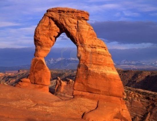
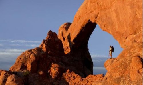
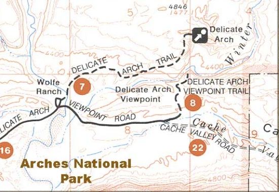
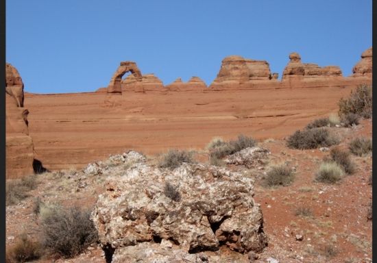
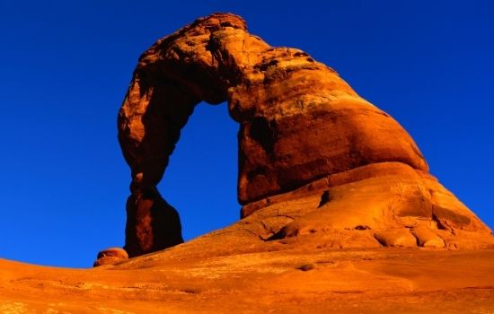
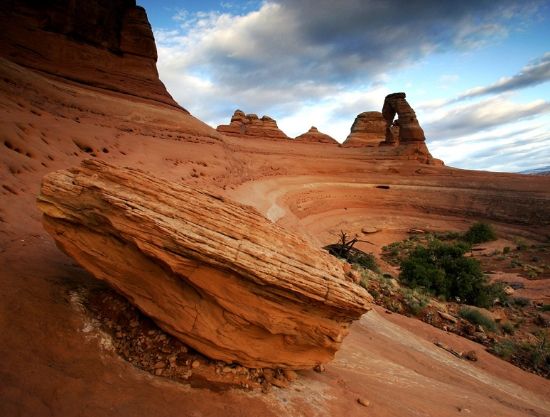
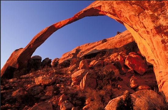
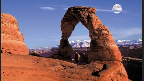
Easily, The Planet's Most Iconic Arch: The trail to the Delicate Arch destination leads to a remote sector of the park. Its well-traveled pathway departs from the Wolfe Ranch parking area. The first .5 mile is relatively easy and traverses over flat to gently inclined terrain, which marks the Morrison Formation overlying the Entrada Sandstone. The somewhat strenuous 3-mile roundtrip to this aptly named arch is perhaps the most photographed backdrop on the Colorado Plateau; certainly here in Arches NP. The caveat, however, is this particular icon is for hikers only. Although its iconic shape can be viewed from far away, it’s simply too far from any nearby road or walkway to do the camera lens any good in capturing the majesty of its formation as well as the engaging background of the La Sal Mountains. Note that there’s hardly any shade in this part of the park. Thus, it’s advisable to have plenty of water, a decent pair of hiking shoes, and of course a broad-brimmed hat. Some hikers even prefer carrying an umbrella for added shade.
The arresting thing about seeing this rare spectacle of nature is the suspense in getting there. It simply builds because Delicate Arch doesn’t come into view until the very end of the hike. (So the usual comments from many hikers is "Are we there yet?") Its freestanding sandstone sculpture clings precariously to the sloping edge of a large stone amphitheater. Like other arches in the park, this famed arch is constructed in the striking wind-blown layers of the Entrada Sandstone (Jurassic Period). Yet Delicate Arch stands alone: there are no flanking fins to protect it. This geologic fact also means it’s lifespan compared to other protected arches is relatively ephemeral.
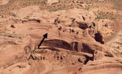
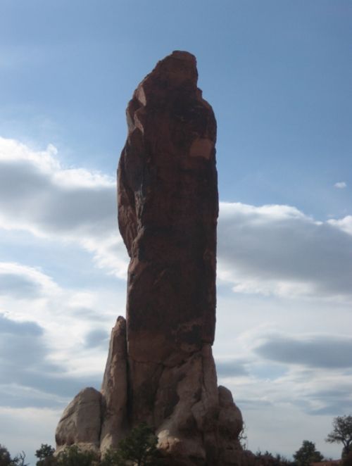
And from a high-flying raven's POV this landmark tends to blend in with its sandstone terrain camouflage. . .
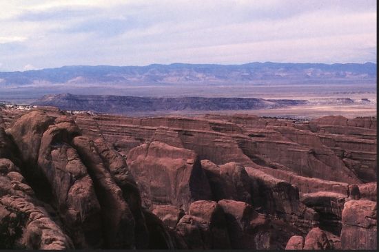
Situated high above Cache Valley––a collapsed salt anticline––and set against a picturesque background of the La Sal Mountains (meaning “the salt” in Spanish), the panorama here is nothing less than an outdoor shrine of sandstone beauty.
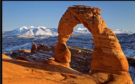
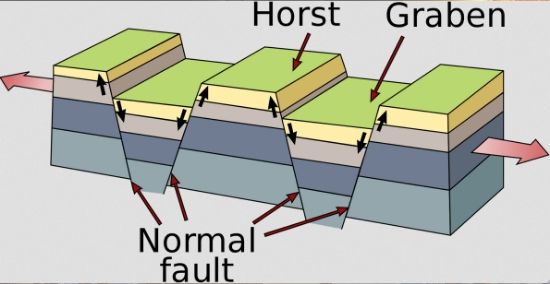
That towering mountain landmark beyond the unusually-shaped arch may appear like a mountain, but in actuality it’s a laccolith––formed by magma and domed like a mountain. In this vicinity of the park the strata of formations were broken and tilted by down-faulting along the margin of Cache Creek Valley. The valley is actually a graben (a depressed block of land bordered by parallel faults) that formed when the Cache Creek salt anticline collapsed millions of years ago.
What a splendid place to learn about geology (which is not a subtle way for me to introduce such stuff. . .but needs must). In this case, the aforementioned graben is the German word for "ditch" and can be singular or plural. A single or multiple graben can produce a rift valley. Grabens are produced from parallel (normal) faults, meaning compressional. Thus the hanging wall is downthrown and the footwall is the opposite, upthrown. Typically, the faults dip toward the center of the graben from both sides (hence, compressional). In short, the geologic result here reveals a huge block of land that’s literally downthrown which then produced a valley with a distinct scarp on each side. (A scarp is a steep slope or long cliff that results from erosion or faulting and separates two relatively level areas of differing elevations.) Graben often occur side-by-side with horsts which typifies the raised fault block bounded by normal faults or graben. Horst and graben structures are important to take note of, because they can indicate tensional forces including crustal stretching. Think of horsts as parallel blocks that remain between grabens. The bounding faults of a horst typically dip away from the center line of the horst.
Continuing the trail description, it passes the historic Wolfe Ranch cabin (on the left), then crosses a bridge over Salt Wash. The pastel-colored green and purple shale visible in the slope on the right represents mud that accumulated in the floodplain next to the Morrison streams (an ancient channel of some 151-million years ago). Beyond the bridge, at about the .4 mile point, the trail connects to a switchback up through the sandstone and shale layers, then levels out before winding down again. The large, irregular boulders along the trail are blocks of chert (a micro-crystalline variety of quartz). These vivid rocks called agate are weathered out of conglomerate layers in the Morrison Formation. The trail soon begins a precipitous climb to a slickrock surface in the Entrada Sandstone. At first, the terrain looks awfully homogenous. Keep your eyes peeled for trail markers (called "cairns") which will help keep you on the right path.
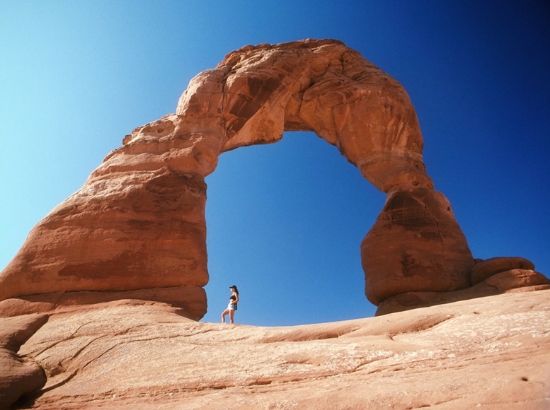
For about the next .5 mile watch for rock cairns that mark the route. After the steep climb the trail eventually levels out where it crosses sand and sandstone pavement of the ancient Entrada sand dunes (obviously long since petrified). Along the way twisting trunks of piñon pine and juniper trees accent the sandstone garden in this sector. When the trail begins its traverse along a narrow rock ledge the arch is close. Ultimately, the trail ends at the top of the ridge. Seeing Delicate Arch defines one of those special Ooo-ahhhh moments. It’s that breathtaking! The arch, which some think looks like a pair of legs minus the torso and head, artistically frames the symmetrical peaks of the mountainous backdrop appearing like a towering black boil raised on the skin of landscape.
Of course, perspective is everything and this arch is indeed massively sized.
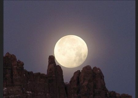
For some, who don't mind a long hike back to the trailhead in the dark, this celebrated landmark is even more stunning wit the backdrop of the cosmos (but you better bring along a flashlight with a backup):

And who knows, there might even be a full moon, whose ivory colored orb acts like a celestial lamp to help see where you're going. . .
The Awe Of An Arch: Delicate Arch is a marvel of erosion. It originally formed in a continuous sandstone fin. Gradually over time, the sandstone on either side fell away until only the arch remained. What keeps it standing, like a frozen monument? It’s the harder rock layer that caps the arch which is more resistant to erosion than the layers below. It’s also the hardness that keeps this arch from washing away, as in disintegrating this sublime spectacle. Of course, nothing lives forever––not even the rocks and most especially arches. Notice that the left leg of this majestic arch is thinner where it is weathering more rapidly than compared to the other side. As mentioned earlier, the leg will become thinner through time and ultimately Delicate Arch will catastrophically collapse in a heap of rubble, leaving only memories and pictures behind.
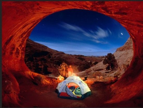
By the way, you do know camping in such places is 'for sure' illegal anywhere in the park, dude? Besides, can you imagine the surprise of having a chunk of sandstone suddenly break loose in the middle of the night and targeting the tent you're illegally sleeping in? Do tell!
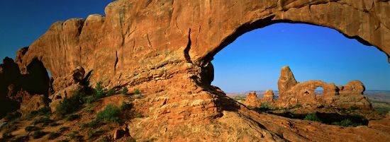
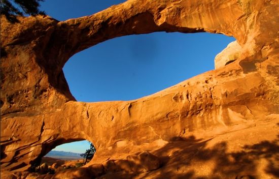
Is An "" The Same As A "Window?" Often people assume this to be the case. HOWEVER, both exquisite designs of Nature are really not the same. Equally, natural bridges are not arches. Albeit both are geological formations involving sedimentary rocks, usually sandstone, arches are formed as a narrow ridge and walled by cliffs. What is more important is that they are formed by erosion, where a softer rock stratum beneath a cliff-forming stratum gradually erodes OUT to the point a freestanding arch forms. Arches commonly form where cliffs are prone to erosion. In this typically dry region, rivers and streams provide ideal and natural weathering processes to do the job. Elements of erosion simply work on inherent weaknesses in rocks and make them larger until their solid foundations are breached. Thus, and from a small opening to a gargantuan aperture, it is fortuitous these marvels of creation appear here in this landscape like no other. . .and so many in number that it boggles the mind.
When you head back to the trailhead, occasionally turnaround and check out the perspective. Even though you traveled this trail en route to the arch it just looks different in the rear view.
See what I mean?
The next recommended tour in the park is much easier and includes a nearby campground. Guess who gets to gawk and not have to walk very far to see the majesty of this usually simmering setting?
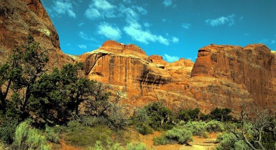
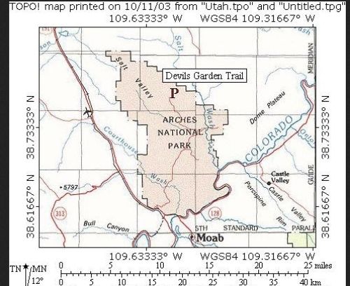
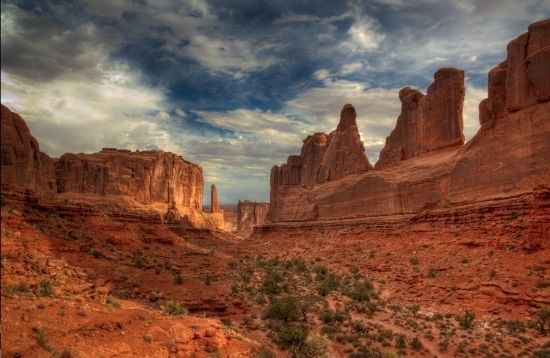
The Devil's Garden And Not The Garden Of The Devil: This interesting locale of Arches NP is also inside the park’s broad domain. This, the longest trail in the park, is a loop path that meanders to the Garden. It’s a wonderfully varied area of arches, fins, canyons and slickrock terrain beyond the far end of the road. The distance marks 6 miles along a direct route or 7.5 miles including various spur trails. For most people Landscape Arch is the chosen destination along this trail. Beyond this the route is rougher, though even more interesting. Here's part of what the backdrop looks like:
Following this pathway. . .
You head toward this wonderland of honed rock features:
And finally, into the reality of this strange and inviting setting:

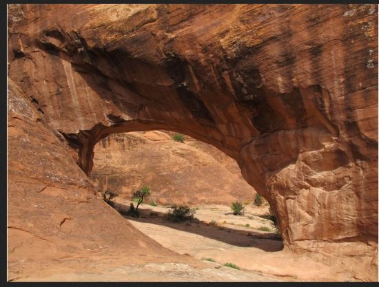
Landscape Arch rises along a ravine between two vertical blocks of sandstone.
Further down a slope stand the impressive Pine Tree and Tunnel arches.
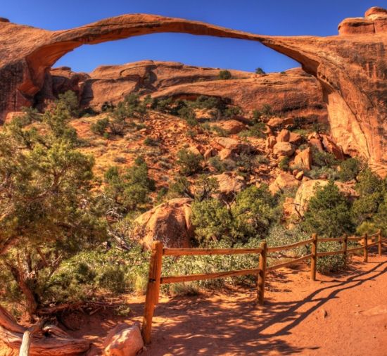
The main trail continues straight and level to the base of Landscape Arch which is .8 miles from the parking lot. Until recently visitors were allowed to walk under and around the arch. However, several rockfalls in recent years warrant keeping the area closed. It appears this magnificent arch will not survive much longer. Its huge 291-foot span is little more that 3.2 feet thick at its narrowest point and has several lengthy fractures.
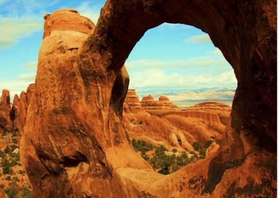
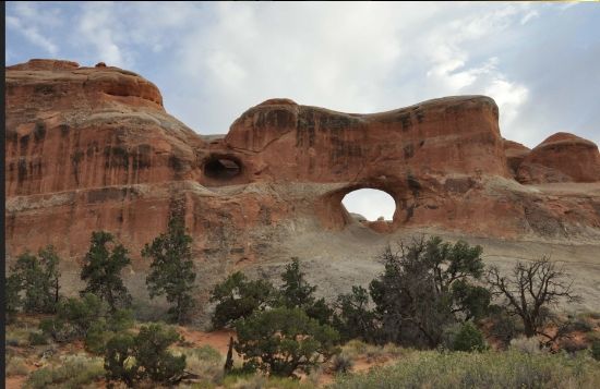
Beyond Landscape Arch the terrain becomes steeper and more uneven. The trail also gains appreciable height as it enters a maze of narrow, sandy-floored ravines between sheer fins and ridges. The next three landmarks are Wall Arch which is formerly the twelfth largest in the park. However, on the night of August 4, 2008 this epic landmark collapsed beside the main path. Keep going, because Navajo and Partition arches are next. Both are reached by two short side tracks on the southwest side. From this junction, and just after an exposed walk along a narrow ridge (though not dangerous), the path reaches the unusually shaped Double O Arch where one large oval span lies above a second, smaller one. Another .4 m side pathleads to a rock pinnacle known as Dark Angel. It rises beyond where the rocks fade away. Here is also a compelling view over a vast area of desert and mountains to the northwest.
Note: Double O Arch marks the end of the path. The majority of hikers turn around here and go back the same way.
However, there’s an alternative return route along a primitive loop trail that heads northeast down Fin Canyon, then vectors south across a wilderness of slickrock and sandy washes for 3.5 miles.
Eventually, the path rejoins the main path close to Landscape Arch. This section of the trail has some steep sections and is not always easy to follow. Nevertheless, there’s some spellbinding scenery along the way and one more arch to see––Private Arch which is along a 0.2-mile side trail.
And so you are at the end of the trail. . .now what? There are many other hiking trails to consider, all of which depends on both the time you have to spend in the park and your physical and mental ability to embark on any of these destinations. Always remember what your mental appetite desires, in the way of hiking, your body also has to match. Know your limitations! It's as simple as that.
Here are some parting shots of this wanderland of sandstone sculpturing. . .
And so, DKos community, we come to the end of another trail and hiking adventure. There’ll be other hikes and places to tour, including more supplemental topics to add to your knowledge banks. I hope you'll join me on the next tour. Thanks, also, for your continuing support.
As always, your thoughtful commentaries are welcomed.
Rich
http://www.nmstarg.com/...
http://www.grandcanyon.org/...
P. S. A complete list of all diaries submitted thus far can be found by clicking on my profile. And starting this Tuesday there will be a 3-part back-to-back series on archeoastronomy. . .truly an engaging topic, particularly its relevance to the Ancestral Puebloans.
