Part 1, Part 2, Part 3, Part 4
This diary is the fifth of a seven-part series on Maine’s political geography. In this diary, I will discuss the three counties of Northwestern Maine: Oxford, Franklin, and Somerset. These three counties take in a wide swath of Maine that reaches from near Sebago Lake all the way to the Canadian border. This area is very mountainous, and the topography of the area has dictated the human settlement patterns here, and has played a role in the political geography of the area as well.
This is a region of small towns, as the largest town here, Skowhegan, has only 8,589 people. However, just because there aren’t any cities doesn’t mean there aren’t interesting political patterns here.
Color code for the maps below (and for all other maps like this that I draw):
Darkest blue: 80%+ for Democrats
Dark blue: 70-79.99% for Democrats
Normal blue: 60-69.99% for Democrats
Lighter blue: 55-59.99% for Democrats
Lightest blue: 50-54.99% for Democrats
Yellow: No candidate received an absolute majority of votes
Pink: 50-54.99% for Republicans
Normal red: 55-59.99% for Republicans
Brown: 60-69.99% for Republicans
Dark red: 70-79.99% for Republicans
Darkest red: 80%+ for Republicans
Gray on the State Senate map represents towns won by independent candidates. White represents towns where no one voted. Green represents uninhabited townships.
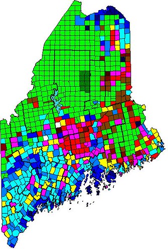
Here is a map of Obama’s performance by town in 2012:
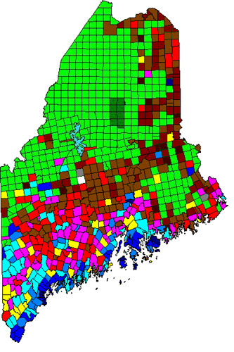
Here is a map of Maine’s Question 1 (gay marriage) in 2012:
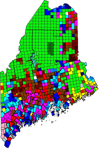
Here is a map of Maine’s State Senate results in 2012:
Follow me over the fold to begin… with Oxford County!
Oxford County
Oxford County is one of two counties in Maine that border New Hampshire, one of five counties in Maine that border Canada, and the only county that borders them both. It is the most populous of the three counties in this region, and extends much further south than either Franklin or Somerset Counties. This results in the Route 2 corridor not having as much influence countywide as in Franklin and Somerset Counties, where all the major towns are on Route 2. While Rumford, the largest town in Oxford County, is on Route 2, there are large areas south of it also in Oxford County. Thus, Oxford can essentially be divided into two regions: the Route 2 corridor, in the northern part of the county, and the small towns in the southern part of the county. With regard to politics, Oxford County is a bellwether for the state of Maine as a whole; voting similarly in both 2008 and 2012.
The southern part of Oxford County does not have a heck of a lot of political variation; most towns voted between 50 and 55 percent for Obama, with a few slightly above that and a few slightly below that. The largest towns in this area are Norway, Paris (the county seat), and Fryeburg. This is an area of small mountains, substantial but not large enough to create barriers to transportation. This area generally specializes in small-scale manufacturing, and its tourist attractions are few and scattered. Norway and Paris, despite their larger population, are no more or less Democratic than the areas around them. Fryeburg leans Democratic, as it is more of a tourist destination, probably due to its proximity to the White Mountains and the town of Conway in New Hampshire. This area has many lakes, most of which are lined with summer houses. This is probably one factor that keeps this area leaning slightly Democratic. There’s not much more to say about this area, so I will proceed north to the Route 2 corridor.
The Route 2 corridor in northern Oxford County is much more Democratic than the southern part of the county. However, these towns are Democratic for different reasons. The two largest towns here are the neighboring towns of Rumford and Mexico. Both are working-class, unionized paper mill towns, and the Rumford paper mill is so large that you smell a distinct (and relatively unpleasant) odor when driving through town. These towns are some of the best examples in Maine of working-class union towns, and these towns also have a substantial proportion of Franco-Americans, who generally lean Democratic, a phenomenon that we will see more strongly in Aroostook County. The nearby towns of Peru and Dixfield also lean Democratic for the same reason. However, head west from Rumford, and you get to Bethel, a town that is just as Democratic as Rumford but for a completely different reason. Bethel is a ski town, with two ski centers and the huge Sunday River ski area, the first (but not the last) that we will see in Maine. Ski towns attract the sort of rich, environmentally-conscious liberals who would vote strongly Democratic (after all, if climate change continues, then ski areas will have major problems). This phenomenon is most visible in Colorado, but is true of most ski towns across the nation. The small, mountainous town of Newry north of Bethel is similar. This area is more mountainous, and the only roads here are in the river valleys between the mountains. Unsurprisingly, this area is a hiker’s paradise, and contains a large section of the Appalachian Trail (including Mahoosuc Notch and Old Speck, Baldpate, and Wyman Mountains) as well as many other mountains that have open summits and great views. This topography is basically why northern Oxford County is so Democratic, because if not for the mountains (and quick-flowing rivers), neither the paper mills nor the ski areas would exist. This area is one of my favorite areas of Maine.
Oxford County is mixed when it comes to gay marriage. Overall, the county voted 60 percent against gay marriage in 2009, a number which dropped to 54 percent against in 2012. However, there are wide variations. The southern part of the county is largely 50-50, while the Rumford/Mexico area and the eastern part of the county are strongly against gay marriage. Bethel and Newry, on the other hand, strongly support gay marriage due to Ski Democrats generally being socially liberal.
Oxford County contains most of one State Senate district and a majority of a second. The old 13th/new 19th district has a majority in Oxford County and the remainder in Cumberland County. This is generally a moderate area, and the district is represented by James Hamper, a Republican from Oxford (the town, which is in the county). He won his election last year 54-46, winning Oxford and neighboring Otisfield by wide margins, winning most of the other towns narrowly, and losing Fryeburg by a small margin. This result makes sense, since the area is largely constant in partisanship. Hamper’s district became a third of a point more Democratic in redistricting, and voted 53% for Obama, so it should remain on the Democrats’ target list. Oxford County’s other district, the old 14th/new 18th, is based in the Rumford/Mexico area, and therefore is strongly Democratic. It’s represented by John Patrick, a Democrat from Rumford, who won a three-way race in 2012 with 57 percent of the vote (the vote was 57-30-13). The district got slightly less Democratic in redistricting, but Patrick’s solid base of support in the Rumford/Mexico area makes him pretty safe.
Franklin County
Franklin County is probably the most fully mountainous county in Maine. It is also the second-smallest in population, and has only three towns of any size: Farmington (the largest town and county seat), Wilton, and Jay. The rest of the county is basically tiny towns and mountains, quite similar to the areas north of Rumford in Oxford County. Thus, I am not going to divide the county into regions; instead I’ll just discuss the most important and interesting towns. Franklin County is also generally Democratic but, as I’ve said before about other places, Democratic strength is not distributed evenly.
Farmington is the largest town and county seat of Franklin County. Its most important feature is UMaine-Farmington, a branch campus of the University of Maine. As a result of this, Farmington is a solidly Democratic town. Just west of Farmington is Wilton, a former mill town that is now more dedicated to tourism and recreation. As a result, it leans Democratic, but not as much as it would if it were still a mill town. Just south of Wilton is Jay, an economically-depressed mill town that never succeeded in diversifying its economy or coping with decline like Wilton did. Jay is much like Rumford; it is very Democratic, downscale, and unionized.
North of Farmington and Wilton are many tiny mountain towns. Weld, northwest of Wilton, is known for being the location of Mt. Blue State Park, a popular destination for hikers. North of Weld (though there’s no route directly there) is Rangeley, a popular tourist destination. Rangeley, unlike many other tourist destinations in this area, leans Republican, though it is very small in population. The towns north and east of Farmington are politically moderate and less mountainous than the rest of the county. In the northeastern part of the county are two notable towns: Kingfield and Carrabassett Valley. Kingfield is known as the entrance to the Sugarloaf area; it is a nice little town that is politically moderate. Carrabassett Valley (CV) is one town north, but twenty miles away on a winding two-lane road. CV is the home of the Sugarloaf ski area, the largest ski area in the eastern U.S. CV’s politics represent its ski-centric economy, as it is strongly Democratic.
Franklin County is also notable for containing almost the entirety of the High Peaks area of Western Maine: an area where almost all of Maine’s highest mountains outside of Baxter State Park are (if you haven’t heard of Baxter State Park, there will be a lot more on it in my next diary in this series). The highest mountains in the High Peaks area are Saddleback, Sugarloaf, and Bigelow; however it also contains Crocker, Redington, Abraham, and Spaulding Mountains. The Appalachian Trail hits almost all of those mountains, and the large network of trails here are enough to satisfy the needs of any hiker. Although I haven’t spent as much time in this area as I would like to, the places here that I have visited are amazing.
Franklin County is one point to the left of Oxford on gay marriage: it voted 59 percent against in 2009 and 53 percent against in 2012. Most of the towns were against gay marriage even in 2012 while Farmington and Kingfield narrowly supported gay marriage and CV supported gay marriage by a wide margin. Jay voted particularly strongly against gay marriage, even more than Rumford, since Rumford has a small ski area to balance it out while Jay is just socially-conservative, unionized mill workers. Most of the rest of the county voted between 55 and 60 percent against gay marriage in 2012.
The entirety of Franklin County, except for Jay, is located in the old 18th/new 17th State Senate district. Despite the Democratic lean of the district (which also extends into western Kennebec County), the district is represented by Thomas Saviello, a Republican from Wilton. Looking at the election results, it is clear that Saviello is extremely popular in Franklin County. He got more than 60 percent in heavily-Democratic Farmington and CV, 75 percent in his hometown of Wilton, and more than 80 percent in a few towns also. The Rangeley area only voted against him because his opponent was from there. Saviello also won all but one of the Kennebec County towns in his district, though with much smaller margins than Franklin County. This all added up to a 62-38 win for Saviello in a district that voted 56 percent for Obama, and despite the district’s moving a point to the left in redistricting, Saviello looks to be safe. When he is termed out of office, though, Democrats should make a strong push to retake this district.
Somerset County
Somerset County is different in many ways than Oxford and Franklin Counties. It is generally less mountainous, though it still contains many mountains. It is also markedly less Democratic than Oxford and Franklin. However, it certainly doesn’t belong with Piscataquis and Penobscot Counties to its east, as its major towns of Skowhegan, Norridgewock, and Madison are on the Route 2 corridor and much more similar to the towns of Oxford and Franklin Counties. That being said, Somerset County does contain a transition zone east of Skowhegan between the moderate rural areas of the mountainous northwest and the strongly conservative rural towns of Piscataquis and Penobscot Counties. Somerset can be divided into three regions: the central part of the county, containing most of the major towns in the county; the sparsely populated north, including the northern Kennebec valley and the Jackman area, and the conservative eastern part of the county.
The central part of Somerset County contains most of the population of the county. Skowhegan, the county seat and largest town, is a mill and factory town. It and Madison have New Balance shoe factories, and this is one of the reasons why Angus King opposes the loosening of tariffs on shoes. Skowhegan leans Democratic, while most of the other towns in this area, including Norridgewock, Madison, and Anson, are moderate. Fairfield, located just south of Skowhegan, is more aligned toward Waterville than the rest of Somerset County; it leans slightly Democratic, and its State Representative district was won last year by a faculty member at Colby (who lives in Fairfield, of course). This region does not extend much east of Skowhegan, because east of Skowhegan we get to…
The conservative eastern part of the county, which continues in much greater numbers east in Penobscot County. This area contains towns such as Pittsfield, Hartland, Harmony, and St. Albans. This area is part of the most populous solidly-Republican area in Maine, electing two State Senators and many more State Representatives. I will talk more about this region in my next diary, when I get to Penobscot County.
Finally, north of Madison and Anson are a series of tiny towns along the northern Kennebec River. These towns, including Solon, Bingham, and Moscow, are generally politically moderate. However, if you go even further north, that changes. Not far from the Canadian border is a small town called Jackman, which is literally in the complete middle of nowhere, and is strongly Republican. This area is very sparsely populated, however, and Somerset County’s politics are dominated by the Skowhegan area.
As should not be a surprise from Somerset’s rural nature and lack of colleges or ski towns, it is very socially conservative. It voted 66 percent against gay marriage in 2009, and 60 percent against in 2012. Even in 2012, every town in Somerset County, except for one tiny town, voted against gay marriage, and most did so by wide margins. The eastern towns were mostly above 60 percent against gay marriage, and the Kennebec River towns also voted strongly against. Only Fairfield and Skowhegan were even under 55 percent against. Somerset County is the third-most socially conservative county in Maine, after only Aroostook and Piscataquis, both of which I will discuss in my next diary.
Somerset County contains all of one State Senate district and part of another (which is based in Piscataquis County). This district, the old 26th/new 3rd, is represented by Rodney Whittemore, a Republican from Skowhegan. Whittemore is broadly popular in his district, and won every town in it in 2012, winning 59 percent of the vote in total. Whittemore’s district shifted about three-quarters of a point more Republican in redistricting. That, combined with the inherent difficulty in unseating a Republican who is from the most Democratic part of his district, makes Whittemore pretty safe. However, his district still voted 51 percent for Obama in 2012, so when the district is open Democrats should run a strong candidate here. One possibility would be House Majority Leader Jeff McCabe (D-Skowhegan).
This concludes Part 5 of my series. In the next part, I will discuss North Maine and the Penobscot Valley: Piscataquis, Penobscot, and Aroostook Counties.
I hope you enjoyed reading, and I welcome any feedback or questions!

