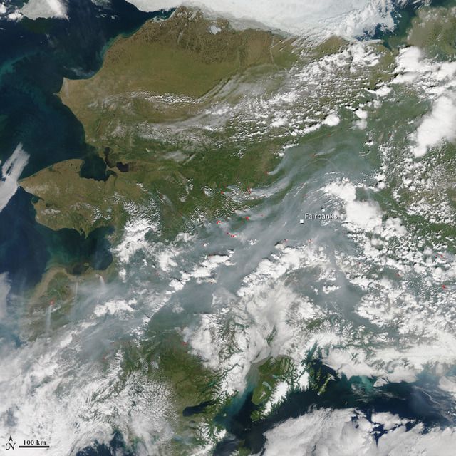
On June 22, the Moderate Resolution Imaging Spectroradiometer (MODIS) on NASA’s Aqua satellite acquired this view of smoke across Alaska. Red outlines indicate areas where MODIS detected unusually warm surface temperatures associated with fire. Active fires surround Fairbanks, so even a change in wind direction would not bring relief from the gases and particles that can cause respiratory and other health problems.
From Big Bear in southern California to Willow in Southern Alaska, fires have been raging across the western states. In the west, vegetation conditions are the worst on record. Ken Pimlott, Director of CAL FIRE recently stated in a recent article, that the situation is so dire that not only is he urging residents to not only not water their lawns, but to also remove the vegetation from lawns and gardens. Removing bone dry vegetation that can intensify heat and potentially spread the fire throughout residential areas is a sensible idea especially in the this changing world.
"We measure the fuel moisture content of all of the vegetation -the brush and the trees and we track that over the course of time and compare it month to month each year,” says Ken Pimlott, Director of CAL FIRE. “And we put it through formulas and determine how much energy and how much heat it will put out when it’s burning. And we have seen -we saw it last year and we will see it again this year- we’ll be reaching records for potential heat output for times of the year that would normally not be burning in those conditions."
In Alaska, smoke is impacting the quality of the air. It has become a major health issue and can pose serious health threats such as pain to the eyes, irritation of the respiratory system, and worsen chronic heart and lung diseases. As you can see from the image above, Fairbanks is surrounded by wildfires and is shrouded in smoke ignited by lightening and burning drought dried vegetation. The soot will travel far and potentially coat areas of the arctic with black, causing an albedo feedback loop that will only worsen the climate of our biosphere.
Climate Central's analysis of 65 years of Alaska wildfire data.
The number of large wildfires (larger than 1,000 acres) suddenly increased in the 1990s, and the 2000s saw nearly twice as many large wildfires as the 1950s and 60s.
In the Arctic region, the number of large wildfires increased nearly tenfold in the 2000s compared to the 1950s and 60s. Only three years in the 1950s and 1960s saw large wildfires; there have been 33 large wildfires in the Arctic since 2000.
The area burned in large wildfires each year is increasing. In just two years, 2004 and 2005, wildfires burned a larger area than in the 15 years from 1950-1964 combined. In particular, there has been a dramatic increase in wildfires larger than 10,000 acres but smaller than 50,000 acres.
Alaska’s wildfire season is about 40 percent longer now than it was in the 1950s. The first wildfires start earlier in the year, and the last wildfires are burning longer into the fall. Overall, the wildfire season has increased more than 35 days and is now more than three months long, running from May through early August.
Rising temperatures across Alaska have been concurrent with the rise in the number and size of Alaskan wildfires. Years with the hottest May to July temperatures also tend to be years with the most fires, and the greatest area burned.
According to the National Climate Assessment, the amount of area burned in Alaskan wildfires is projected to double by 2050 and triple by 2100 under continued emissions and further warming.

