My world is juicy. Has the drought ended? The meadow around me is plump and green, earth soft beneath my feet. Rain striking grass, porch, roof, trees, camellias is background music to my life. As wind gusts approach, I hear them coming like the roar of a distant waterfall and then leafless lilacs rattle against the west windows and the wind growls louder as it fights through the tall dense incense cedar south of the house.
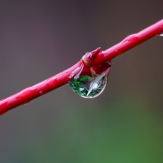
 Doomed cedar buds on moist soil with two mushrooms and cat’s ear rosettes.
Cedar buds not yet ready to open shred off the tree’s leaf tips. Red pistache fruits in open clusters drop from high in the tree and shatter, leaving the fruits accessible to ground-feeding birds. Wildflowers and weeds nestle close to the soil.
Water binds us together: sky, earth, trees, animals, fallen fruits, wildflowers, weeds, wind, and me.
The moist air is like a hug from someone I love who has been away so long I forgot their face, the feel of their hands and soft strands of hair, the sound of their voice.
Someone who was incommunicado, doing something dangerous. It’s more than being glad winter rains have returned; it’s being grateful they could return.
Now, rivers, creeks and ravines are lively. Water bounces off rocks and plants recharging our psyches. We share photos and videos of dry creek beds now full of water, waterfalls thrive after five years of drought.
The drought isn’t over.
| The Daily Bucket is a regular feature of the Backyard Science group. It is a place to note any observations you have made of the world around you. Animals, weather, meteorites, climate, soil, plants, waters are all worthy additions to the Bucket. Please let us know what is going on around you in a comment. Include, as close as is comfortable for you, your location. Each note is a record that we can refer to in the future as we try to understand the patterns that are quietly unwinding around us. |
 Tulare County, California in January 2016.
This year winter feels right. People smile and say “Isn’t it great!” and tell me how relieved they are to have a normal winter season. We who live close to earth feel life flow along with nature’s rhythms. Due to drought, fifteen years of wildfires, and perhaps from repeated TV refrains of weird weather everywhere, people are pulled closer to nature, even those people who prefer sidewalks and shopping malls. Everyone’s bodies intrinsically know seasonal patterns and now everyone notices water spirit all around.
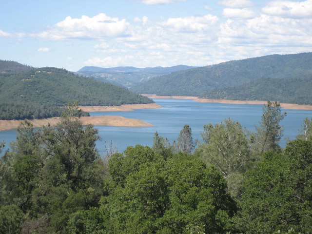
When the nearby reservoir’s water level rose 27 feet in two days social media rocked with the news, even though that means only one-third full and the lake still looks like a giant stock pond with bare soil slopes pathetically stretching high above boats crowded into a narrow channel. Chris Saraga’s 23 January video from Table Mountain celebrates our water. Last year when I hiked to this waterfall it was a trickle. The stream before the waterfall was about eight inches wide, a few inches deep, and barely flowing.
local and state-wide precipitation this season
California’s drought isn’t over; rains haven’t reached normal average amounts yet. And the depleted groundwater needs immediate and longterm help. Scientists say the snowpack needs to be at 150 percent by April to ameliorate the drought’s effects this summer. Late January is about half way through our usual rainy season and we had 28 percent of normal annual rainfall at the end of December. That was 76 percent of the normal average rainfall in those months. January through March usually bring the heaviest rains and January’s recent rainfall gave us ten inches of rain in nine days. The table below has the National Weather Service’s precipitation amounts in inches for my region (water year = the rainfall so far this season in 2015).
| oct |
nov |
dec |
water year to date |
% of average to date |
% total Average Rainfall |
| 0.52 |
4.91 |
10.60 |
16.03 |
76 |
28 |
This is the present status of rainfall and snow amounts throughout California.
The LA Times reports on California’s current rainfall situation.
The water content in the snow in the northern Sierra Nevada is at 124% of average for this time of year; the central Sierra clocks in at 115% of average; and the southern Sierra at 92%. The statewide average is 113%.
But to come close to digging California out of the drought, the Sierras need 150% of average by April 1, state water officials estimate — an ambitious benchmark that is still a long way off. […]
The storms have sent steady amounts of water into California’s largest reservoirs. Still, those reservoirs — Shasta Lake, Lake Oroville, Trinity Lake and New Melones Lake — are only at 42%, 36%, 24% and 15% of capacity, respectively.
Since the rains began, Lake Oroville has risen more than 27 feet. . . . But the lake still feels empty. […] Recent storms are not coming directly from the El Niño-fueled pattern but from a typical path of winter storms riding the polar jet stream from the northern Pacific Ocean.
lake oroville, california — drought icon
 Lake Oroville in August 2014. Another year of drought happened after this photo was taken. By mid-January 2016, the lake reached one-third capacity. (Photo by Steven Zavestoscki)
The reservoir near me, Lake Oroville, has been the poster kid for California’s drought — an iconic image featured in The Guardian and NY Times. On December 9, 2015, Lake Oroville receded to the lowest water level for the year, almost the lowest water level since it began filling in 1969.
 Part of Lake Oroville one year before the current drought, in May 2010. Still not full as evidenced by the bare slopes along the lake margins. (Photo by Suzi Rosenberg)
If you want a closer look at how sad Lake Oroville has been check out this Youtube video taken by someone walking on the dry cracked lakebed near the 770 foot tall earthen dam (highest dam in the US). When full, Lake Oroville holds 3,500,000 acre feet of water and has 167 miles of shoreline.
A sprawling 3,222 square mile drainage basin mostly in the northern Sierra Nevada Mountains flows into four Feather River tributaries that feed the lake (the entire drainage basin is 6,000 square miles when you include the portion below the Oroville Dam). Two of the tributaries begin east of the Sierras in the Diamond Mountains, cross over the Sierra crest into the west slope watershed and drain into Lake Oroville. (The fourth tributary is unlabelled on the map below and is the shorter watercourse extending west of the North Feather and north past the dot marking Paradise, and is called the West Fork.)
 The Feather River watershed showing the origins of the four tributaries in the Sierras and, upper right, in Indian and Last Chance Creek drainages of the Diamond Mountains. The dam is just upstream of Oroville and downstream are Feather’s confluences with Bear and Yuba Rivers before the Feather River joins the Sacramento River.
groundwater resources, wells, and the incredible sinking central valley
No, the drought isn’t over. And even with snowpack in the Sierras over 100 percent of normal and the reservoirs beginning to look more like lakes, one season won’t solve California’s water deficit. The Union of Concerned Scientists (UCS) reminds us that the water we see isn’t all we depend on — groundwater is essential. (My bold added below.)
During the four-year drought, groundwater supplied half of California’s water.... While aquifers can hold up to three times more water than surface reservoirs, they do not fill as quickly. In addition, our groundwater reserves have been depleted much more than those above-ground reservoirs that you are used to seeing pictures of—you know, the ones with the bathtub rings and the dry docks above parched soil that once was a lake bed.
The situation underground is far, far worse
Rather than being low, many of California’s groundwater aquifers are completely tapped out and in negative territory. In the Central Valley, we have been withdrawing about 2 million acre-feet of water more than we replace each year for the last decade.
Restoring our aquifers will take careful management of groundwater extraction (among other measures), something that is not regulated in California although all other western states do so. The Sustainable Groundwater Management Act of 2014 is the first attempt to comprehensively measure and monitor groundwater in California. Think about this: California has not measured how much groundwater is stored beneath the state. But anyone (generally) can tap into it and pump it out. And what is pumped out is not accurately measured.
As groundwater is pumped and used, large swaths of California land are sinking. The subsidence is caused by over-extraction of groundwater triggering collapse of a clay layer deep below the loamy Central Valley (CV) soils. Farmers in some areas of the CV are drilling new, deeper wells because older wells have run dry (groundwater level dropped), and the deeper wells result in more water extraction and more subsidence.
Some areas are sinking two inches per month. Along the California Aqueduct through the San Joaquin Valley (i.e., the Central Valley region south of Sacramento) some places have sunk 1.25 feet in two years.
...long-term sinking has already destroyed thousands of private and public groundwater well casings in the agriculture-dependent valley, adding that over time more sinking could permanently reduce how much water can be stored in the underground aquifer[….] Because of increased pumping, groundwater levels are reaching record lows - up to 100 feet (30 meters) lower than previous records….
It will take generations of careful groundwater management to restore the aquifers, if seasonal rainfall and snowpack are normal. Our rains this season do not signal the end of a drought, nor do they solve the deeper problems of poor water assessment and management.
But when it’s raining, air feels soft. Bright green new growth spreads out and prepares for blooms of golden monkeyflowers spilling down swales, and yellow poppies, magenta owl’s clover, and blue lupines scattered across slopes and buttes.
We flora and fauna relax our inner drought tension. But earth remembers and clenches.
| "Spotlight on Green News & Views" will be posted every Saturday at 5pm Pacific Time and every Wednesday at 3:30 Pacific Time on the Daily Kos front page. Be sure to recommend and comment. |