|
The Daily Bucket is a nature refuge. We amicably discuss animals, weather, climate, soil, plants, waters and note life’s patterns.
We invite you to note what you are seeing around you in your own part of the world, and to share your observations in the comments below.
|
January 15, 2022
Salish Sea, PacificNorthwest
Last Saturday, Hunga-Tonga-Hunga-Ha'apai volcano in Tonga violently erupted causing extensive local destruction and generating a tsunami that propagated thousands of miles across the Pacific in every direction. Much more information can be found elsewhere about the devastating effects in Tonga. This diary is about what we saw here in the PacificNorthwest as a consequence of the tsunami.
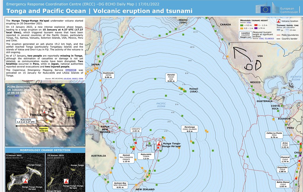 Map showing tsunami direction, arrival time and height at destination shorelines.
From Global Disaster Alert and Coordination System, a joint UN and EU organization
As you can see from the graphic, the worst tsunami effects were in Tonga itself, and on the coast of South America. By the time the wave reached North America it was between 4 feet and nothing. Almost all preliminary reports were less than a meter and most were less than half that.
 Early reports. Yellow circled = near where I live
We were watching the news like everyone else. The tsunami was predicted to reach the inland waters of the Salish Sea where I live around 10am. By then we could see reports from up the coast and down Strait of Juan de Fuca, and it was clear the tsunami wasn’t going to be much if anything by the time it got here. But we went down to the bay just to see. Yes, we heard the recommendations to stay away from the shore but real-time data showed the height lessening to negligible as the wave entered our inland waters. Even so we watched from a distance for a while and then parked down by the dock.
The tide wasn’t high where we were, unlike locations in California where they had some flooding. The lower water level in itself provided a buffer for any small wave effect here. I stood on the dock platform by the road and watched the water movement. That day the weather was calm and the water flat calm. Foggy, no air movement. No boat activity either. Here’s a video I took:
.
Looking at the rock in the foreground, there was water movement up and down a couple of times and then it subsided to what it had been. I suppose it’s possible that was a fragment of tsunami that started 12 hours earlier and almost 6000 miles away. If so, that would be pretty amazing!
NOAA (the National Oceanic and Atmospheric Administration) maintains buoys and fixed stations in U.S. waters which monitor and document oceanographic and atmospheric conditions. Here’s a graph showing predicted and actual water level on the open coast of Washington. Preliminary data shows about half a foot of up and down at the time the tsunami reached shore (La Push) — the wave had mostly spent itself. Interestingly, there’s a fair bit of wiggling over the next day. The big up and down is the tide.
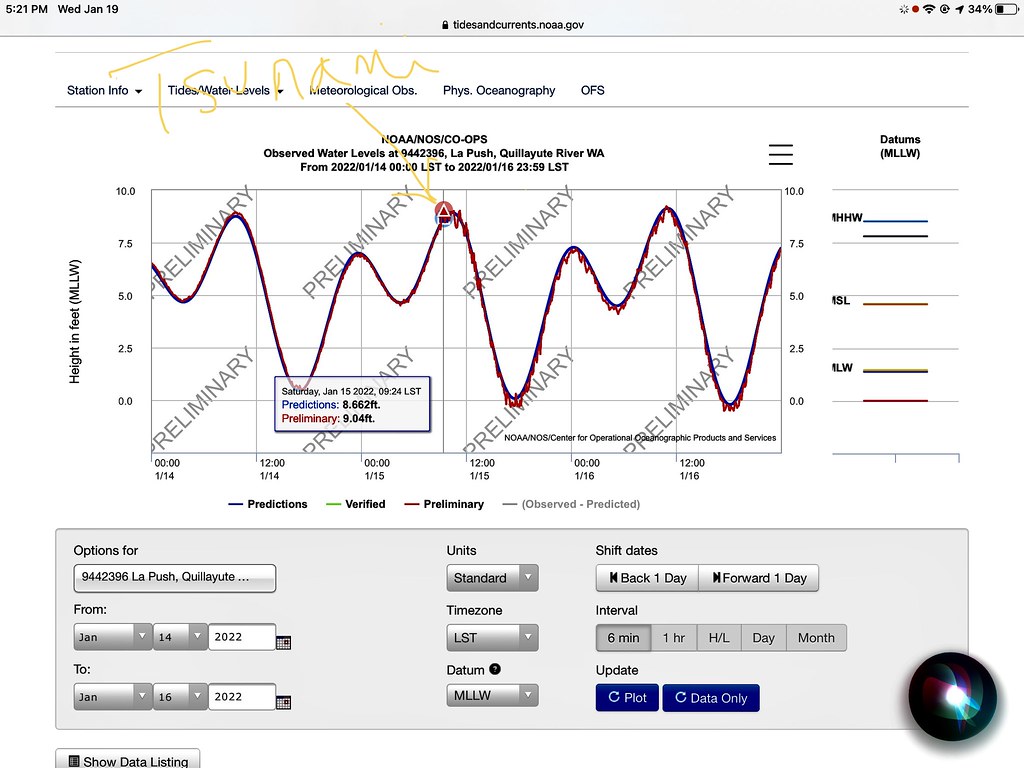 La Push. January 14-16, tsunami reached there around 8:30-9:00 am.
 Yellow arrows show direction of tsunami wave
From there, the tsunami would have to turn a couple of corners getting down to where I live. See map.
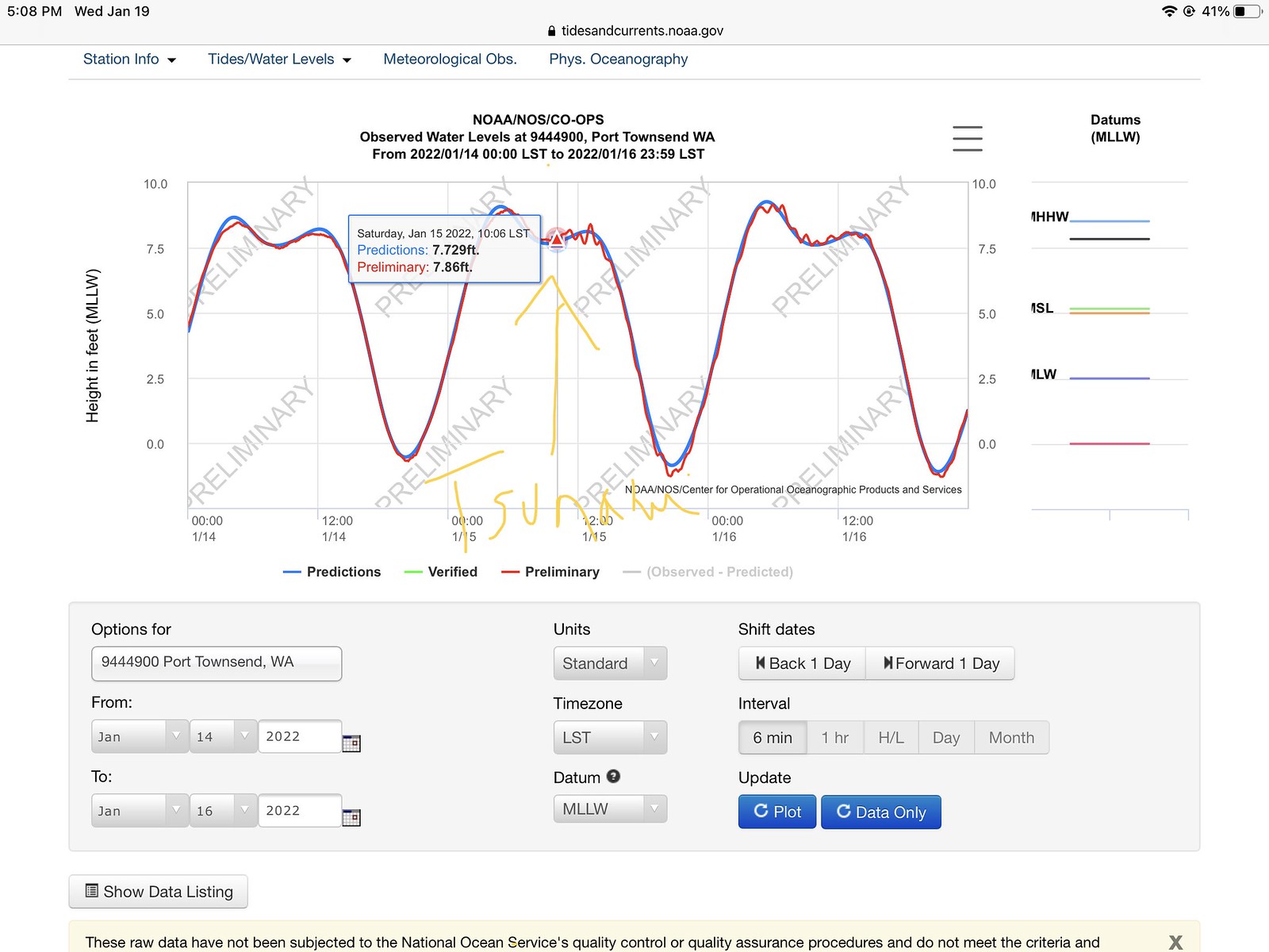
My nearest NOAA station recording water level currently in operation is in Port Townsend.
Preliminary data from there shows a difference from predicted water height of 0.12 feet, or 2½ inches. That’s about the amount of swishing in the video. So it’s possible we were seeing a remnant of the tsunami right here. Maybe.
There’s a bigger change in predicted tide level we see that’s more impressive than these few inches. It happens whenever a strong low pressure system rolls through — storms off the Pacific — which is common in winter around here. It’s called the The Inverse Barometer Effect: high atmospheric pressure pushes water level down and low pressure allows water to rise higher in that area than normal/average atmospheric pressure would. Tide tables are calculated using average atmospheric pressure. There’s a nice little diagram at that link showing the comparison.
When a low pressure system coincides with an especially high tide (ie around winter solstice near full moon), we get a King Tide. The water level is visibly higher during King Tides, as on the occasion I took a video at the same dock several years ago. In this case I’m aiming the camera at the place I was standing to film the tsunami video above. There was no beach at all during King Tide.
.
For comparison, I pulled up a graph of the predicted and measured water level that day. Sea level was more than 2 feet higher than expected at Port Townsend! It may not have been that high here but it was as high as it ever gets. The dock and headwalk were not built to be immersed. With sea level rise that will surely happen during King Tides in future.
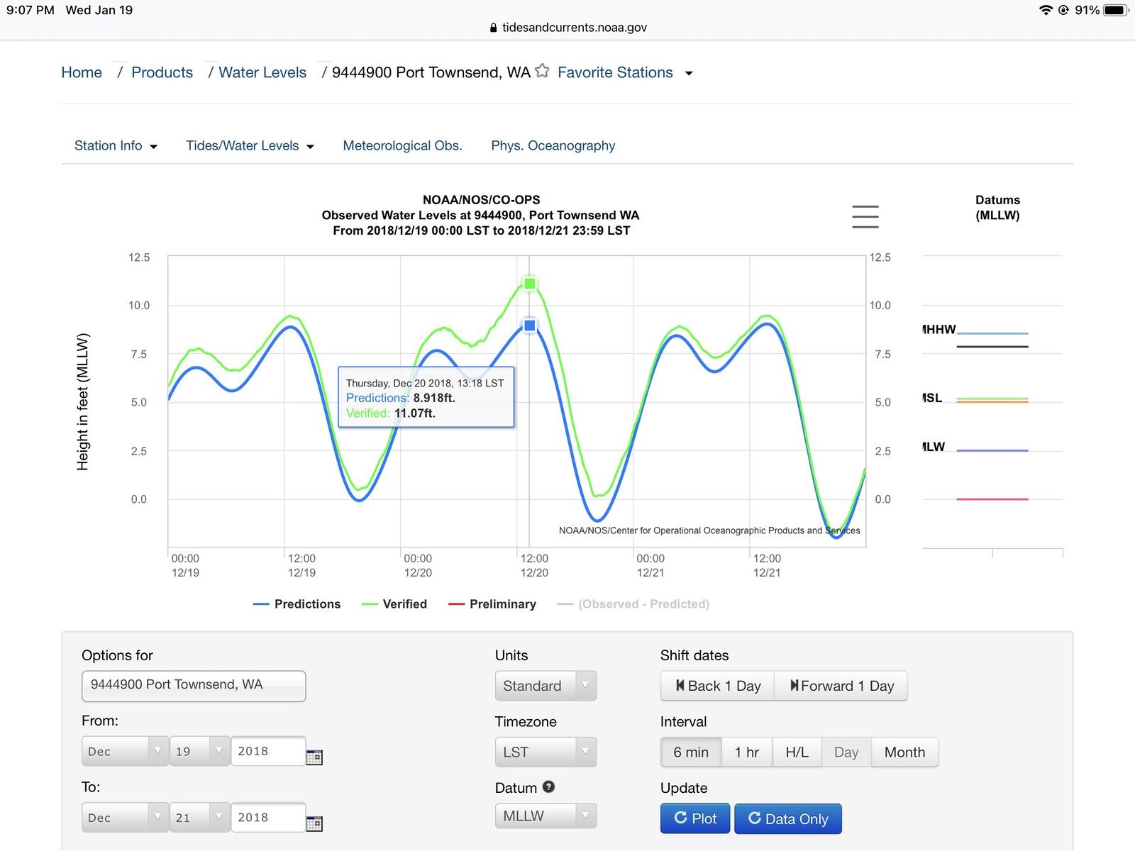 King Tide. December 20, 2018. These happen every year, but I happened to film this one.
Now granted, tide waves are bigger at the shore, but they are slower than tsunami waves, taking 12+ hours from one crest to the next. Generally you can keep ahead of an incoming tide, although on very flat beaches you can get caught. A foot of vertical change means a long distance. People do die that way, by not being aware of their surroundings.

Tsunamis however are completely unpredictable and can pack tremendous energy when they hit a shoreline. If there was a major undersea earthquake off our coast along the Cascadia fault, the tsunami wouldn’t have far to go and it would inundate us: Study: Tsunami from Cascadia mega-quake would submerge Puget Sound waterfront. A tsunami like that would reach my beach in an hour and a half and might be a 10 foot high wall of water, submerging all our shorelines, some quite a ways inland. Hopefully folks will have enough warning to get to higher ground. People living along the open ocean coastline like La Push won’t have as much warning, and the tsunami will be higher.
That’s why we take tsunamis seriously along this coast. The Tonga tsunami was a negligible artifact for us here on the other side of the ocean — I could see that, watching the data as it approached. A Cascadia Fault tsunami would be a whole different thing. I’d be up on high ground!
We were happy to have a calm foggy day down at the bay Saturday instead.

💦💨💦
Wind picking up in the PNW islands today, rain has stopped. Temps in the high 40s F. A quick warm front.
WHAT’S UP IN NATURE IN YOUR AREA TODAY?

