November 2022
Olympic Peninsula
This Bucket continues the story of my trip to the ocean earlier this month. Part 1 is here: The Daily Bucket - November ocean trip, Part 1 (rainy n windy)
By Saturday morning the atmospheric river had dumped most of its precipitation. The skies brightened up with a mix of scudding multilayer clouds and what we in the Pacific Northwest call sunbreaks. It was still breezy though and showers came through for the next couple of days. But it was much better weather for longer walks outside, especially with family who came out for the weekend.
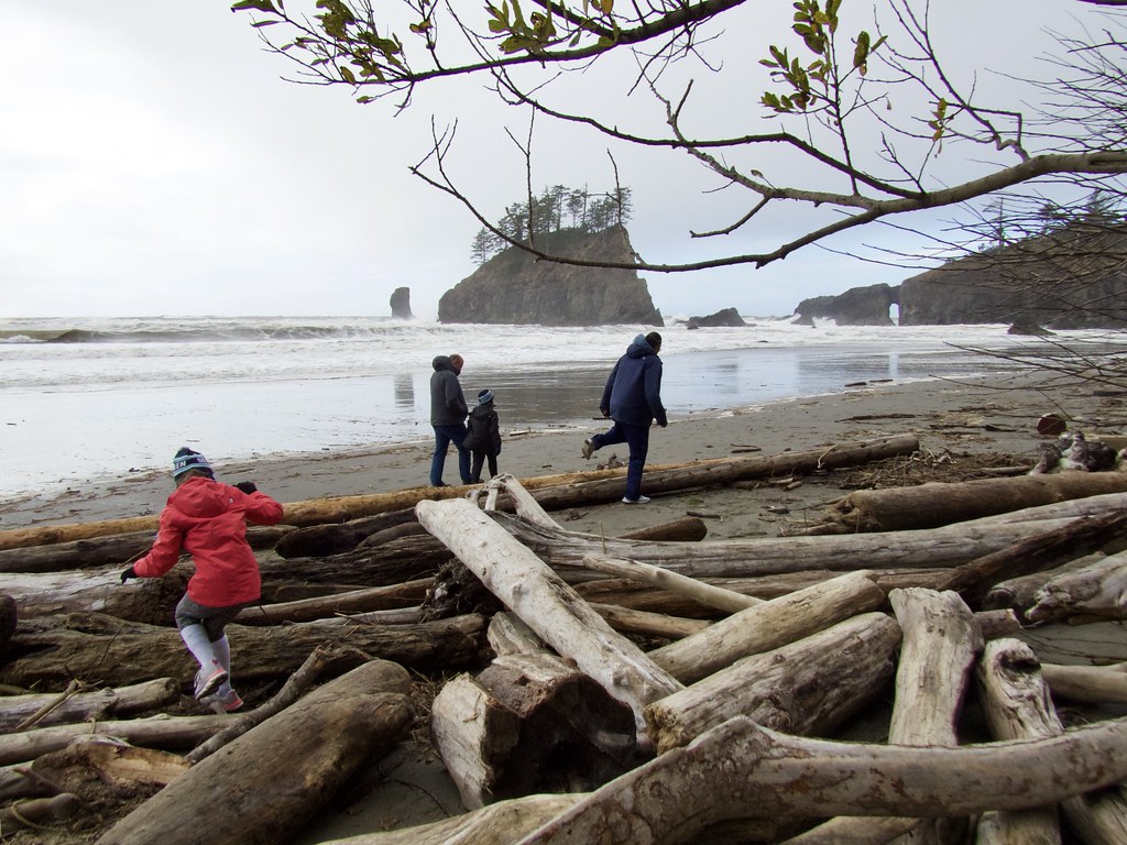
 Grandchildren greeting the ocean and playing with waves on First Beach
With the change in conditions, I noticed the hundreds of gulls around the mouth of the Quillayute River had shifted their behavior. Earlier, during the height of the storm, they flew a pattern, from one end of the beach to the other in flocks of hundreds, always staying over land….back and forth. Here’s part of one pass:
.
But after the worst of the storm had moved through, the flocks went offshore, dipping into the breaking waves snatching food. Generally speaking, gulls move inland in bad weather to avoid getting blown away and because fishing is poor in dark chaotic ocean conditions. The gulls instead were scouting out possible food sources washed up onto the beach by the surf.
When the weather improved they moved back offshore to take advantage of food sources stirred up in the swells and surf. Visibility was much improved under the brighter skies.
Gulls are exceptionally good at maneuvering among swells and waves, strong and versatile. They can soar, scoping out targets, and then quickly change direction, climbing, diving, snatching food from near the surface without falling in, even where the ocean is shifting powerfully, randomly and in three dimensions. Gulls have split second timing.
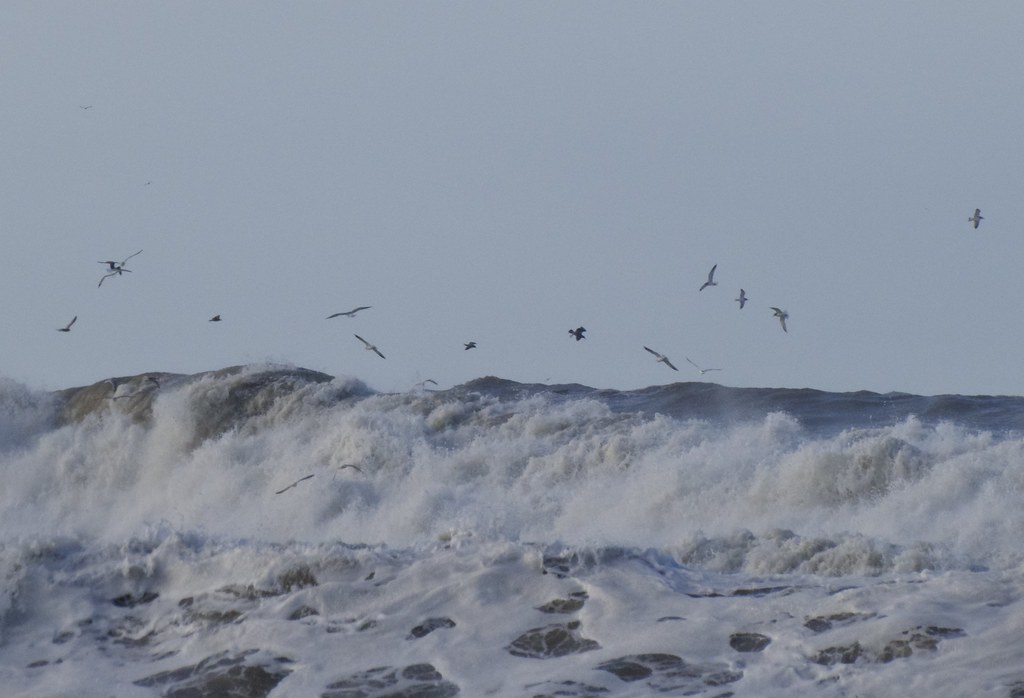 Gulls are feeding in the breaker zone and just outside it
.
We took a short hike out to Second Beach, ¾ mile through temperate rainforest. This trail gets a lot of traffic but it’s through unlogged forest. It’s part of Olympic National Park.
 Light green= Olympic National Forest
Dark green= Indian Reservations (along the open coast: Makah, Quileute, Hoh, Quinalt)
Medium green= Olympic National Park, both mountain and coastal sections
Protection of this coastal forest was a near thing. Starting in the 19th century, logging companies systematically clearcut whole forests of gigantic towering thousand-year-old conifers on the Olympic Peninsula, obliterating ancient temperate rainforest habitat. Government stepped in, first Teddy Roosevelt in 1909, who designated the Olympic mountains as a National Monument (to protect elk), then in 1938 Congress and Franklin D Roosevelt further protected the area by making it Olympic National Park. Under Harry Truman the coastal strip was added in 1953. There were many attacks on ONP by the logging industry over the years, the 600,000 acres of lowland Olympic National Forest evidently not being enough to feed sawmills, pulp mills and bank accounts. These grabs were mostly staved off by political and citizen action.
In 1958 tourist interests were about to punch a national highway through the heart of the coastal wilderness so Washington would be like Oregon, a coastline seen through car windows while speeding by. Conservationist leader Polly Dyer organized a high profile protest, a 20-mile hike from Ozette to Rialto, which included Supreme Court Justice William O.Douglas (can you imagine any Supreme Court justices doing something like this today?). The publicity of the hike galvanized outrage which ended the highway project. In 1988, Congress put most of ONP into Wilderness Area status, including the 73 mile coastal strip. It’s only 10 to 20 miles wide but it means when you’re walking the beaches and rocky headlands you are as close to wild as it’s possible to get in these days.
 A lot of standing water in the trail from the previous few days of steady rain
 Second Beach and Quateata head. There’s a lot less driftwood to climb over these days to get down onto the beach. As the forests get logged inland there are fewer wild trees washing down the rivers — that’s mostly where driftwood comes from.
 collecting sand sample
We hung out at the northern end of Second Beach since the tide was too high to hike around a big rock southward, but that was ok. The kids played in the sand and driftwood. We collected a sand sample, trying to include as much pink garnet sand as possible.The garnet comes from bedrock inland, weathered particles wash down to the ocean along with other minerals. Since garnet is denser than the rest of the sand, it tends to stay longer while lighter particles wash away. But there isn’t much of it here and that layer is only about one grain thick.
Second Beach ends at Quateata head to the north. You can see an arch there in the photo as well as seastacks. The bedrock of the Olympic peninsula is mostly sedimentary, some metamorphosed, formed as deep sea sediment got pushed up onto the North American plate as an accretion wedge (the yellow wedge in the cross section below).
 Formation of arches and seastacks
Since the sources of what compose the bedrock are quite a mix, there are variations in composition and angles along the coastline. In general, harder rock resists weathering by ocean surf and becomes headlands sticking out. Where softer rock wears away, indentations develop and sediment collects there: that’s where the beaches are. Those rocks and islands just offshore? At one time they were very resistant rock along the coastline. Millions of years of powerful waves carved away surrounding bedrock leaving isolated seastacks. Arches are a transitional feature. The current coastline, where we hike the beaches, has eroded quite a distance inland during those millions of years. It’s hard to imagine the features we see as not being permanent — to me, headlands and stacks look just the same as when I first saw them in the 1960s. But of course our human lives are just a quick flash of existence. Long after we’re gone the coastline will continue to change.
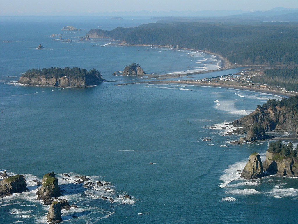 From top, in Sam Beebe’s aerial photo: Cape Johnson, Rialto Beach, Quillayute River, town of La Push and First Beach, Quateata head, Second Beach. Lower left are the Quillayute Needles, a set of seastacks hazardous to boaters but great for nesting seabirds.
Quateata head (Qw'aatilla, to the Quileute people) separates First and Second Beaches and it cannot be hiked around. Here’s a video clip of surf at Quateata as seen first from Second Beach and then from First Beach. The scale of all that power and age and vastness is humbling.
.
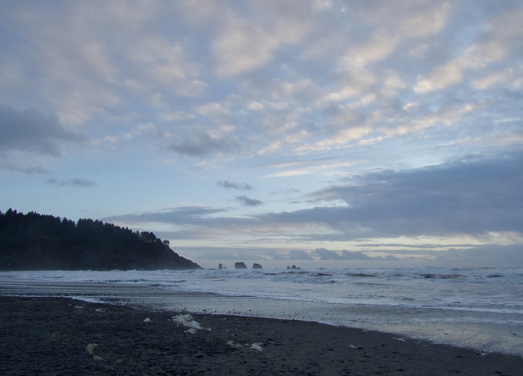 The storm passed through. Winter sunset at the ocean.
Next day was a long drive home but it was worth the travel. The open coastline of the wild Pacific always joyfully fills my senses and spirit.
🫧
|
THE DAILY BUCKET IS A NATURE REFUGE. WE AMICABLY DISCUSS ANIMALS, WEATHER, CLIMATE, SOIL, PLANTS, WATERS AND NOTE LIFE’S PATTERNS.
WE INVITE YOU TO NOTE WHAT YOU ARE SEEING AROUND YOU IN YOUR OWN PART OF THE WORLD, AND TO SHARE YOUR OBSERVATIONS IN THE COMMENTS BELOW.
FOR MORE INFORMATION ABOUT THE PURPOSE AND HISTORY OF THE DAILY BUCKET FEATURE, CHECK OUT THIS DIARY: DAILY BUCKET PHENOLOGY: 11 YEARS OF RECORDING EARTH'S VITAL SIGNS IN OUR NEIGHBORHOODS
|
🫧
Partly cloudy in the PacificNorthwest islands today. Light breeze. Temps in 30s.
WHAT’S UP IN NATURE IN YOUR AREA TODAY?


