"`They sought it with thimbles, they sought it with care;
They pursued it with forks and hope;
They threatened its life with a railway-share;
They charmed it with smiles and soap. '" -- Lewis Carroll, The Hunting of the Snark
Lately, there's been a hunt on for a fabulous beast. It's being stalked in Ohio by those who think this critter serves to feed the even more fearsome beast known as Diebold. It's being chased across it's traditional range in Massachusetts by a coalition that spans the political spectrum. And out in California, the beasts faces the fading fury of he who was the Terminator.
The creature, of course, is the Gerrymander, that serpentine defender of the incumbent and friend to Tom Delay. But as the hunt intensifies and spreads to more states, the question has to become: do we want to drive the Gerrymander to extinction? Is it always a varmint, or does it sometimes show a more noble nature?

The type specimen for Gerrymanderus politicus(Stuart, 1812) was described in Massachusetts, but it's a wide-ranging beast, well known not only throughout the United States, but in most countries of the world that practice electoral politics (the creature seems to have a fondness for ballot boxes). Party affiliation is not limited -- there are both red and blue varieties of the Gerrymander. Recent examples include Delay's 'mandering of the Texas districts in order to generate more Republican congressmen from the Lone Star State, and the cooperative Gerrymandering of the California legislature, in which both parties worked together to cement their seats in place.
There's a lot to dislike about Gerrymandering. Fredick Clarkson has an article up over at Political Cortex, outlining the Massachusetts efforts and the sound reasons they give for stalking this critter on his home turf. It's all too easy for those in power to manipulate the system so they stay in power, and just as easy for them to increase their power. If you want to get a good idea of what Delay was up to, you need look no further than this entry in the Wikipedia.
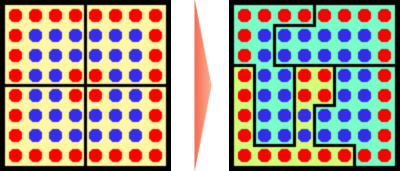
The image on the left shows four districts that are fairly evenly matched. In any given year, there's a good chance that seats could change hands, and on average you'd bet that each party controlled two seats. On the right, thanks to the magic of "packing and cracking," the blue party has assured themselves of three nearly unassailable seats, while abandoning a single district to the reds. Reverse the colors, and you have exactly what went on in Texas.
In addition to being drawn along party lines, districts have also been extended to group people by race or by similar social characteristics. In many cases, Democrats have supported this kind of Gerrymandering, because it can be used to maximize representation of minorities through generation of the oddly named "majority minority" districts.
So what happens if you throw out all the rules, put a supposedly apolitical commission in place, and start making districts according to boundaries that don't respect party, race, or class? It's difficult to say. Different groups have proposed different means of determining district boundaries. To see the effects of some different schemes, let's look at results from Missouri's 2000 general elections (because I live in Missouri and that's the last date that works out neat for an example, that's why).
In that election, Republicans took 5 of the state's 9 US house seats, allowing such odious toads as Roy Blunt to remain in office. Democrats, including Dick Gephardt, took the other 4 seats. However, if you total all the votes received, Democrats actually had a slight advantage. If the state had been broken into "blocks" each of which contained the same number of people who voted, the results would have been 5 to 4 Dems. And that's before you consider voter turnout. Even in 2000, the Springfield wingnut contingent was highly energized, giving that region the highest turnout in the state. If the state had been broken along even blocks of population, not voters, the results could have easily swung even further to the Democratic side.
On the other hand, it's just as easy to draw boundaries that would have given the Republicans the advantage. If the boundaries had followed county lines, only breaking where needed to adjust for population, the high concentration of Democrats around St. Louis and Kansas City would have made for a very effective "packing" scenario that might have limited Democrats to only two or three seats. We also may well have lost minority representation by seeing the populations around the cities mixed into districts with heavily white suburbanites.
Personally, I'd be willing to go for the Israeli system, in which everyone is thrown into one big national pot, people vote, and then representatives are doled out on a percentage basis. Short of that, there's no guarantee that reshaped districts will be any more fair, or any more advantageous to Democrats, than the Gerrymanders we have now. And they certainly won't look as fun on the map.
Still, it's good to see that recent efforts at punative redistricting have finally made people wake up to the statistical games being played when district lines are drawn. In the best of all solutions, they'll draw the lines so every representative is on a hot seat, no one is safe, and representatives have to... represent.
(cross posted at Political Cortex)

