Franz Josef Land, Franz Joseph Land, or Francis Joseph's Land (Russ. Земля Франца-Иосифа, Zemlya Frantsa-Iosifa) is an archipelago located in the far north of Russia. It is found in the Arctic Ocean north of Novaya Zemlya and east of Svalbard ... At latitudes between 80.0° and 81.9° north, it is the most northerly group of islands associated with Eurasia. The extreme northernmost point is Cape Fligely on Rudolf Island. The archipelago is only 900 to 1,110 km (560 to 690 statute miles) from the North Pole, and the northernmost islands are closer to the Pole than any other land except for Canada's Ellesmere Island and Greenland.
...
In 1926 the islands were taken over by the Soviet Union, and a few persons were settled for research and military purposes. Access by ships is possible only for a few summer weeks and requires a special permit.
-- Wikipedia summary of travel to Franz Josef Land
Read any description of Franz Josef Land and you'll see the same thing. The path to Franz Josef Land is always choked with ice. During the summer, enough ice normally clears from the southern edge of the islands to allow at least limited access, although the northern coast remains embedded in pack ice. In September of 1932, it made news when am unusually warm branch of the Gulf Stream removed the pack ice from the north shore, allowing the heretofore unknown feat of circumnavigation of the islands without icebreaker.
Arctic sea ice typically bottoms out in early September and begins its return in earnest in October. By this point in November, historically, the average edge of the arctic sea ice pack is nearly 300 miles south of the southern coast of Franz-Josef Land. But while summer arctic ice extent this year was only the third lowest on record, right now it's at the lowest point ever recorded for this time of year. Only within the past few days was circumnavigation of the archipeligo cut off by a small tongue of ice.
What happened to sea ice recovery this year?
---
Franz Josef Land is a cold, isolated place.

The average daily high in July is barely above freezing. It has no native population, and its main historical role has been a Russian/Soviet military outpost. It supports populations of polar bears, foxes, walrus, and various arctic birds. Today, it should be in deep freeze, packed far beyond the edge of the ice pack.
It isn't.
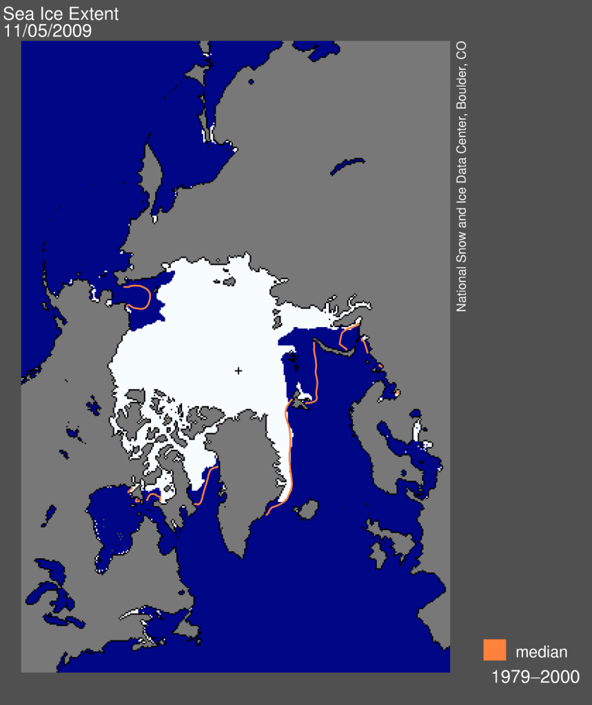
(Franz-Josef Land is the small cluster of islands just east of Svalbard, a large-ish archipeligo east of Greenland and north of Norway. Note that the presence of pack ice (white) does not automatically imply jammed, non-navigable seas)
2007 and its unfortunate arctic air circulation patterns was the year of record arctic ice melt. 2008 and early 2009, facing La Nina conditions as well as less favorable circulations patterns, did not allow for such an extreme melt.
But this year, La Nina has transitioned to El Nino -- a tropical phenomena marked by the reduction in the strength of the westward-blowing equatorial winds (the Walker Circulation), thus leading to a decreased upwelling of deep, cold water off the South American coast. The warmer surface waters mean warmer average planetary temperatures.
Given that the effects of global warming are greatest in the Arctic, this is not a good thing for pack ice:
The net result is that we have already surpassed the daily minimum extent from 2007:
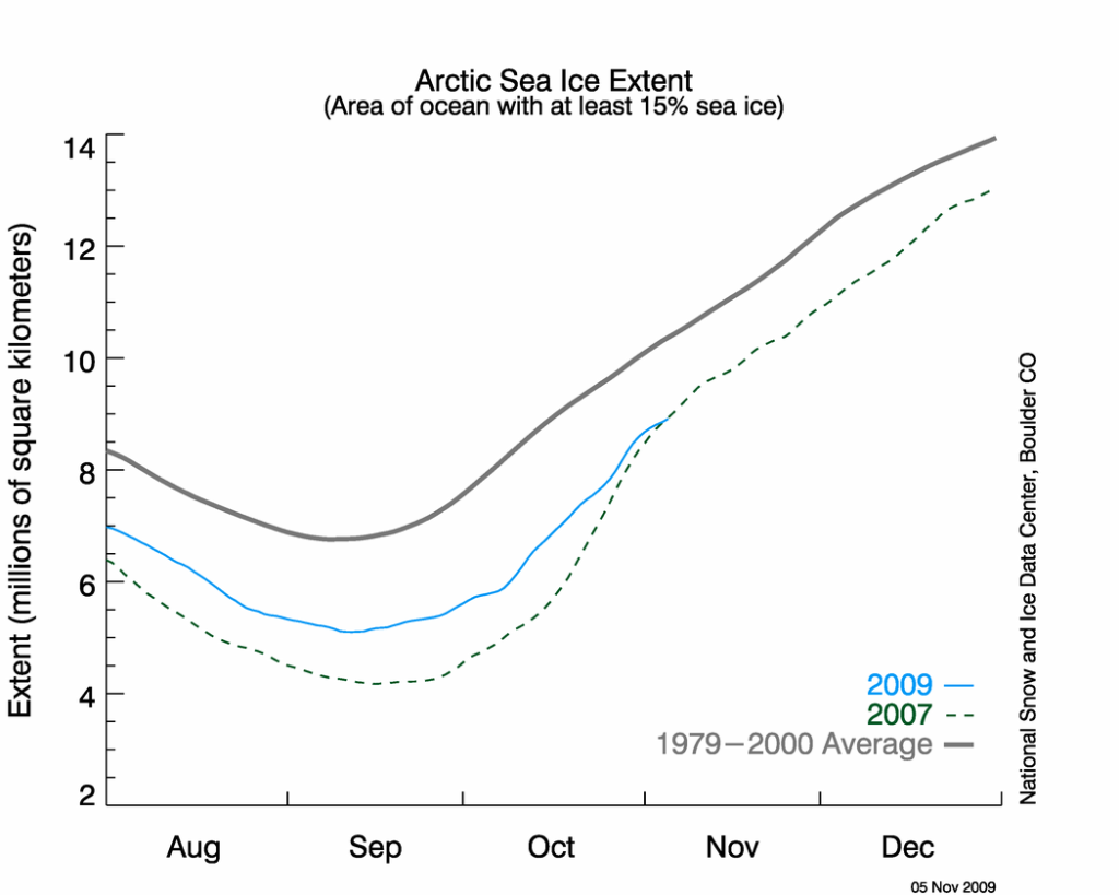
Given that El Nino is forecast to maintain its intensity or strengthen this winter, unless favorable atmospheric circulation patterns take hold in the arctic, we seem likely to be in a bad starting point for next year's melt season.
