This is the next in an occasional series of diaries on the state of Northern Hemisphere Arctic sea ice (and other topics as warranted), written in memory of Johnny Rook, who passed away in early 2009. He was the author of the Climaticide Chronicles.
NOTE: Pardon my lateness. Winter solistice (Northern Hemisphere) was yesterday.
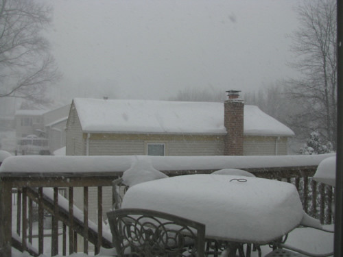
The climate change debate is often (mis)informed by local climate and weather anomalies. We experiencrf such an anomaly here in the Mid-Atlantic states over the weekend. A picture speaks 1000 words (this from my backdoor at noon 19 December 2009; with about 10" of snow on the ground):
By evening we had about 16-18" snow on the ground. I did a second round of shoveling about that time. The third round was Sunday morning. One thing for sure, I don't feel badly about not going to the gym (I'm sure it wasn't open anyway!). More below.
The December 'aught-nine Snowstorm: The Day After
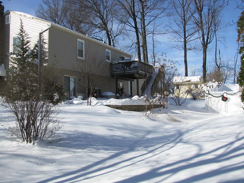
As I said in the intro, I shoveled out the third time on Sunday; mostly the sidewalk, since I did the driveway the second time around dusk on Saturday, and not too much more accumulated there (and the ground was still warm enough before the storm to actually melt some of it from below!). When I finished up the walk and had worked up a good sweat, I went in and got the camera to take some more pictures of this historic snowstorm. This one is from the street toward the back of our home.
The Mr. and I ventured out after that. The only reason we went out is because we'd originally planned to do shopping on Saturday for Christmas (and for groceries/vegetables); that obviously didn't happen. I will say that it was somewhat rough going the 13 miles to Columbia Mall (for you DC/Baltimore metro area folks, you've probably been there). There was a backup on the limited access highway we would normally take, so we had to take some side roads to get where we wanted to be. Thank goodness for the Mr.'s all-wheel drive, 'cuz the side roads were still in pretty bad shape.
The mall was encouragingly busy, for those of us concerned about the effect on the economy of this snowstorm. I hadn't seen it like that in quite some time. While I am less than enamored with our dependence on debt-driven consumption to run the economy, maybe at least in the short term things will get better at least superficially.
But I digress.
Even with our heavy snowfall recently, the month has not been terribly cold here, running actually near normal. The middle of the country has been another story however, though it has warmed up recently. In the meantime, up in Alaska, it was in the upper 30s to near 40 with rain in the southwest quarter of the state the last couple of days, after a relatively brief period (3-5 days) of extreme cold. Fairbanks so far this month is about 2°F above normal, Barrow about 7°F above. The temperature in Nome went from 25° below normal on the 18th to 25° above normal on the 21st. One reporting station in the western interior went from about 32° below normal to 33° above normal in the same span of time. For those of you who know climate terminology, that's what we'd call a continental climate! :-)
Arctic sea ice news follows.
State of the Arctic Sea Ice
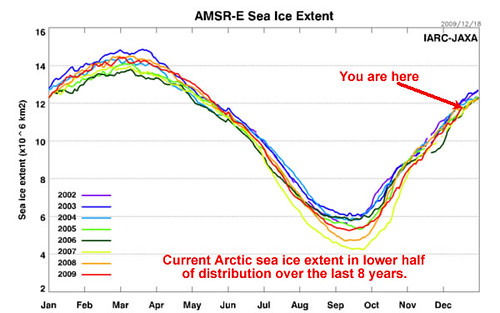
As of 18 December 2009, the sea ice extent in the Northern Hemisphere is in the lower half of the 2002-2008 distribution, as can be seen in the graphic below from the Japan Aerospace Exploration Agency joint mission with the International Arctic Research Center in Fairbanks AK.
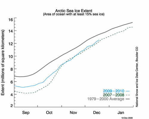
Sea ice has been increasing at a pretty good, slightly better than average pace. This can be seen in the alternative graphic of sea ice extent from the National Snow and Ice Data Center with a comparison to 1979-2000 mean sea ice from September through December. There is also a comparison to the 2007-2008 sea ice year.
Area coverage right now is above normal in the Bering Sea, and below normal in the Davis Strait and Barents Sea; this is shown in the graphic below.
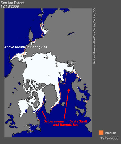
In the Davis Strait, there have been persistent and mild southeasterly winds blowing around an equally persistent area of low pressure over northern Quebec and Labrador and out into the North Atlantic, and a blocking high pressure area (both at the surface and up to at least 5-km aloft) over Greenland. This is one of the typical setups with what is known as a "negative" North Atlantic Oscillation a.k.a. NAO (high pressure in the Atlantic high latitudes and Greenland north of low pressure anomalously far south in the mid-latitudes of the Atlantic). Such a pattern also displaces cold air southward into the mid-latitudes of the eastern U.S. and in Europe; this has certainly been seen recently in the eastern U.S. Though overall December temperatures have been near normal in much of the northeastern U.S., there have been several opportunities for snowfall, unlike some years earlier this decade.
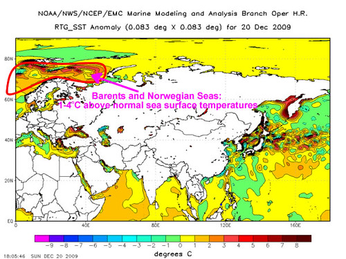
As far as the Barents Sea situation is concerned, sea surface temperatures have remained above normal there and in the Norwegian Sea to the west, to the tune of 1-5°C. It's going to be difficult to make decent sea ice with such an environment, though there's plenty of time for things to change, at least near the sea surface. The Arctic sea ice typically reaches its maximum in early March.
The Antarctic: A polar opposite
I thought I'd throw something new in for this particular diary: the Antarctic. Pardon the punny title to this section. ;-)
In the Antarctic, melt season has been underway since September, with the Antarctic sea ice minimum is typically in March, the mirror image of the annual cycle in the Arctic. The progress of the current melt season compared to last year's and the 1979-2000 normal is shown below.
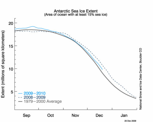
We see that there is less sea ice than last year, and just a small amount more than normal.
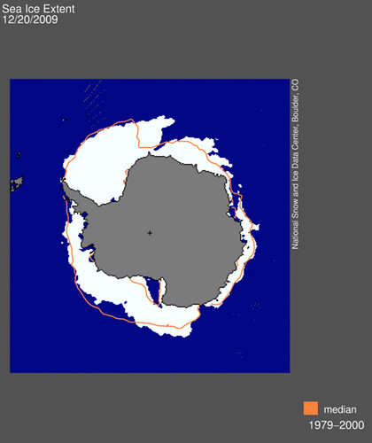
Now we show the map of Antarctic sea ice extent as of 20 December 2009. There are areas above and below normal which seem to more-or-less balance each other out.
As you may know, the Antarctic has shown an opposite trend over the last couple decades to that of the Arctic in terms of sea ice extent, which has shown a slow upward trend over the last 10-20 years.
The reasons, while somewhat complex, are to first order the result of reduced ozone (a greenhouse gas at temperatures of the Antarctic ice sheet (about 2-4 km above sea level)) allowing more terrestrial radiation to escape to space. This in turn has increased temperature contrast between the Antarctic ice sheet and the lower latitudes surrounding it (which have been experiencing warming), increasing the strength and persistence of the Antarctic polar vortex and thus not allowing as much warmer mid-latitude air into the Antarctic.
It is expected that as chlorofluorocarbons continue to be reduced in the atmosphere as a result of use of alternative refrigerants that do not impact ozone in the stratosphere as much, that warming will become more prominent on the Antarctic ice sheet. It already is prominent at latitudes away from the pole, such as the Palmer Peninsula south of South America.
