This is the next in a quasi-weekly series of diaries on the Northern Hemisphere Arctic sea ice melt season. I write these in memory of Johnny Rook, who passed away earlier this year. He was the author of the blog Climaticide Chronicles.
The NOAA North Pole web cam hasn't updated since 29 July, so I found one from Barrow AK for this morning.
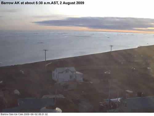
That might be sea ice out in the distance, but I'm not convinced, especially after looking at the sea ice extent graphics I'll show later. However, first a word about arctic sea ice volume trends. Go below the jump.
Sea ice Volume, Age of Sea Ice, and Ice Melt
Sea ice areal extent impacts the albedo of the arctic basin, with fresh snow cover having the highest albedo (around 0.70, or 70% of incoming solar/shortwave radiation reflected) and open ocean having the lowest (about 0.10, or only 10% of incoming solar radiation reflected). What determines the amount of heat required to melt the sea ice is the volume of sea ice, not the areal extent; that is, the area times the depth. What does sea ice age mean in the context of sea ice volume, and why do we care about it?
Here's a reprise of the sea ice age graphic that was published by National Sea Ice Data Center in April 2009. Note the much greater percentage of new (and thin) sea ice at the most recent sea ice maximum, compared to the mean 1981-2000 age of sea ice at the time of maximum sea ice extent.
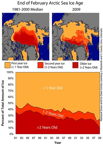
It's clear from the data that young (formed in the prior cold season) ice dominates now, though it hasn't always. The young ice usually reaches a thickness of 2-m (6 feet), while multiyear ice is thicker. But that's not all that's going on.
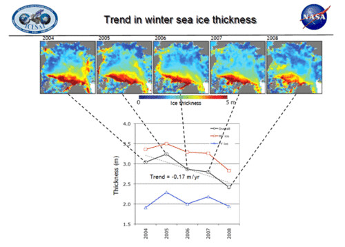
Back in 2004 according to data from NASA's Ice, Cloud and land Elevation Satellite (ICESat) published in an article in Journal of Geophysical Research - Oceans (JGR-Oceans), multiyear ice was about 3.5-m thick; by 2008 it was only about 2.8-m thick, a decline of 20%. Meanwhile, first year ice was remaining about 2-m thick. Overall ice was about 2.4-m thick, also a 20% decrease from the 3-m average for all sea ice in 2004, and even a bigger decline from 2005, when all sea ice averaged about 3.25-m thick. A graphic published by NASA (Kwok et al., 2009) follows showing these changes year by year.
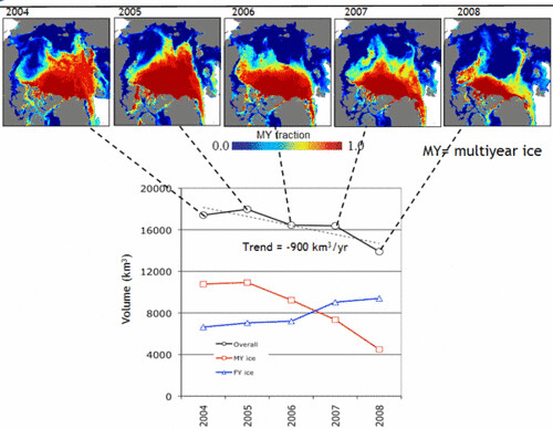
According to the same article in JGR-Oceans, multiyear sea ice volume at areal extent maximum has dropped 40% since 2004, also published by NASA (Kwok et al., 2009). The decrease in thickness and area of multiyear sea ice has dominated the overall decrease in arctic sea ice volume. First year sea ice volume has taken up some, but not all, of the slack.
Will these trends continue this year? Climate Progress put that question to the folks at NSIDC last month and this is what they were told by Research Scientist Walt Meier:
It is too early to say how 2009 will end up and what we might be able to say about the volume. One thing is that last fall a lot of first-year ice remained. Younger ice is thinner ice in general. That’s one reason why we thought 2008 was probably lowest. But that first-year ice thickened over the winter and this summer it is second-year ice, probably a bit thicker than last year. But some of that ice got moved out of the Arctic by the winds, so a lot depends on how much total ice and the proportion of ice of different ages in terms of making an assessment.
We won't know the sea ice volume when the extent is at its minimum right away...but will probably know if a new record was set by the end of this calendar year.
Current Year Arctic Sea Ice Trends: Week of 26 July 2009
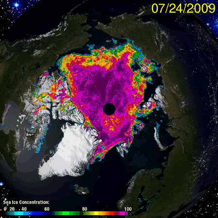
The first image below is an annotated sea ice concentration map from the Univ of Illinois Urbana-Champaign for 1 August 2009, with a comparison to 24 July 2009 below that.
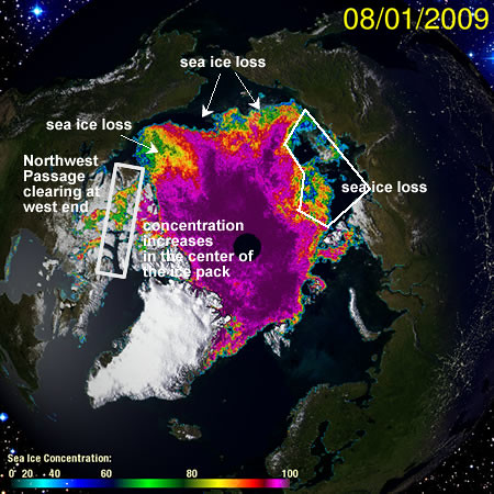
"Largish" sea ice losses since 24 July have occurred north of the Canadian mainland, in the Northwest Passage, the Chukchi Sea north of AK, Bering Sea, and easternmost Siberia, and north of central Siberia. UPDATE: So in answer to what that stuff is in the Barrow AK web cam out in the Arctic Ocean, it ain't sea ice.
On the other hand, sea ice concentration percentages have been rising a bit toward the interior of the ice pack. This may be due to wind effects pushing pack ice toward the middle of the arctic basin.
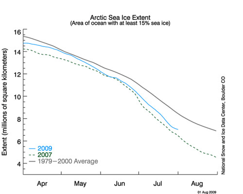
This is reflected in the arctic sea ice extent since the 24th of July, shown below courtesy of the National Snow and Ice Data Center. Until the last couple of days, the time series of daily sea ice loss were great enough to bring this melt year close to that for 2007. Adjustments upward have been made since, however, and there's been a temporary slowdown in sea ice loss in the last two days.
Current Arctic Weather
Weather in the Arctic at 06 UTC 2 August 2009 is shown courtesy of the University of Cologne, Germany, below.
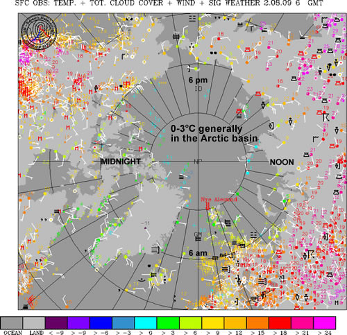
Temperatures over the ice are about 0-3°C throughout. Land masses are rather warm to a high latitude; note the temperatures in the hot pink in many areas, which are 21°C or higher in Asia (noon-6pm) and from about 15-20°C at between 6 pm and midnight over the Canadian west. East of there, the coolest temperatures between say about 8-15°C are found. One of the high points on the Greenland ice sheet is at a chilly, but nothing unusual, -11°C.
Finale
It's interesting, though likely not all that vital to the final result at the end of this melt season, that the melt rate has suddenly slowed. As usual, the weather over the next 6 weeks will determine how things play out for the balance of the melt season, which typically ends at mid-September, about the time the sun is nearly setting to commence the long Arctic winter. Last diary, I put up a graphic of predictions for the minimum sea ice extent from those with some expertise in sea ice forecasting; we'll see where we wind up in 6 weeks plus or minus a week or so and will see how those predictions fared.
