See
nika 7K's diary for live blogging from affected areas.
The northwest Eye Wall of Katrina is passing over NOLA.
LOCAL UPDATES (Text only) & LIVE STREAMING VIDEO (Video down/spotty)
Some levies reported breaking. Superdome roof half gone.
10 EST WU Steve Gregory:
I sent an advisory around 2AM indicating that Katrina was going to weaken a bit, and that it would skirt the east of New Orleans. That's has in fact happened, sparing the city of New Orleans from a truly catastrophic event. See extended
"Good news" maybe misunderstood. Only means those in hardened, high, shelters more likely to escape serious storm injury--Best shelters will probably serve the purpose of providing essential, minimal life-saving protection, most inside will get sopping wet. Worse, most pumps have shut down and grid power is out. There is flooding & collapse of homes and smaller buildings: TENS OF THOUSANDS ARE IN THOSE PLACES. The loss of life could be horrific. Survivors may be isolated without power and food for the forseeable future.
BenGoshi & Liz recruiting local housing diary
Moreover, other coastal/inland areas will be hammered. Biloxi will take the full brunt of the NE Quad of Kat. High winds, Tonados, & Flooding will extend inland for two-hundred miles on either of storm's path.
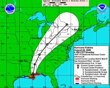
National Hurricane Center: Katrina & Projected Path
Live, Local, Weather & Travel by ZIP Code
Steve gregory's lastest 10 EST E-mail:
** KATRINA WEAKENS SLIGHTLY - CAT 4 - MISSING NEW ORLEANS BY 30 MILES **
Just before heading for some sleep -- I sent an advisory around 2AM indicating that Katrina was going to weaken a bit, and that it would skirt the east of New Orleans. That's has in fact happened, sparing the city of New Orleans from a trulycatastrophic event. The storm is now bearing down on the Gulfport area, and the worst effects will be felt within the next 3 hoursfrom Gulfport eastward for about 30 miles.. The storm has continued to weaken slightly, but will arrive as advertised as a strong CATEGORY 4 hurricane.
The center of the storm is located near 29.9/89.6W or 35 miles SOUTHEAST of New Orleans moving NNE at 13kts Pascagoula, MS just had a wind gust t0 118mph, and Gulfport had 94G100 mph. Winds gusted to 88mph withinNew Orleans itself, with the Lakefront Airport reporting gusts to 86mph. Belle Chase reported had 105mph about an hour ago.
The latest RECON moments ago reports the pressure of 923mb -- and appears to have gone steady state over the past 3 hours. MAX Flight level winds were 129KTs in the east Quadrant 'NORMALLY' this translates to about 130mph sustained surface winds, and gusts to 150mph. I will maintain we will see 'only' sustained surface winds of 120mph, with gusts to near 145mph. A storm surge of 15-20 feet will hit the area along and just east of the area wherethe northern and east edge of the eyewall crosses the coast.
I'll send an additional advisory shortly.
Steve Gregory

