Texas, the southern plains and the southwest will become a permanent dust bowl, if greenhouse gas emissions, causing climate change continue, unabated. In Texas, average temperatures 5 degrees Fahrenheit hotter, combined with permanent drought, will cause rivers and aquifers to dry up and crops to wither and die. Evaporation will far exceed precipitation. Parched cities will be hard pressed to find adequate water supplies for household and business needs. Conventional power generation methods will not have adequate water supplies for producing electricity.

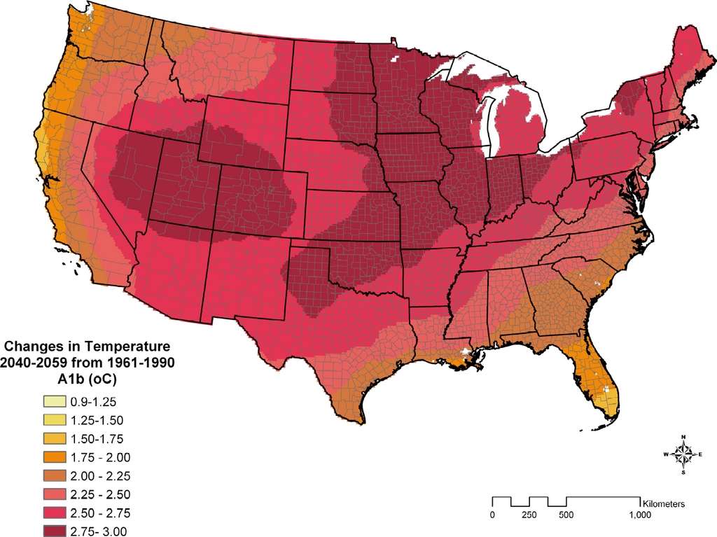
The vast continental interior of the U.S. will heat up 4 degrees F or more by 2050, increasing both evaporation and the demand for water. North Texas and the southern plains states, the heart of red-state America, will see temperature increases of over 5 degrees F.
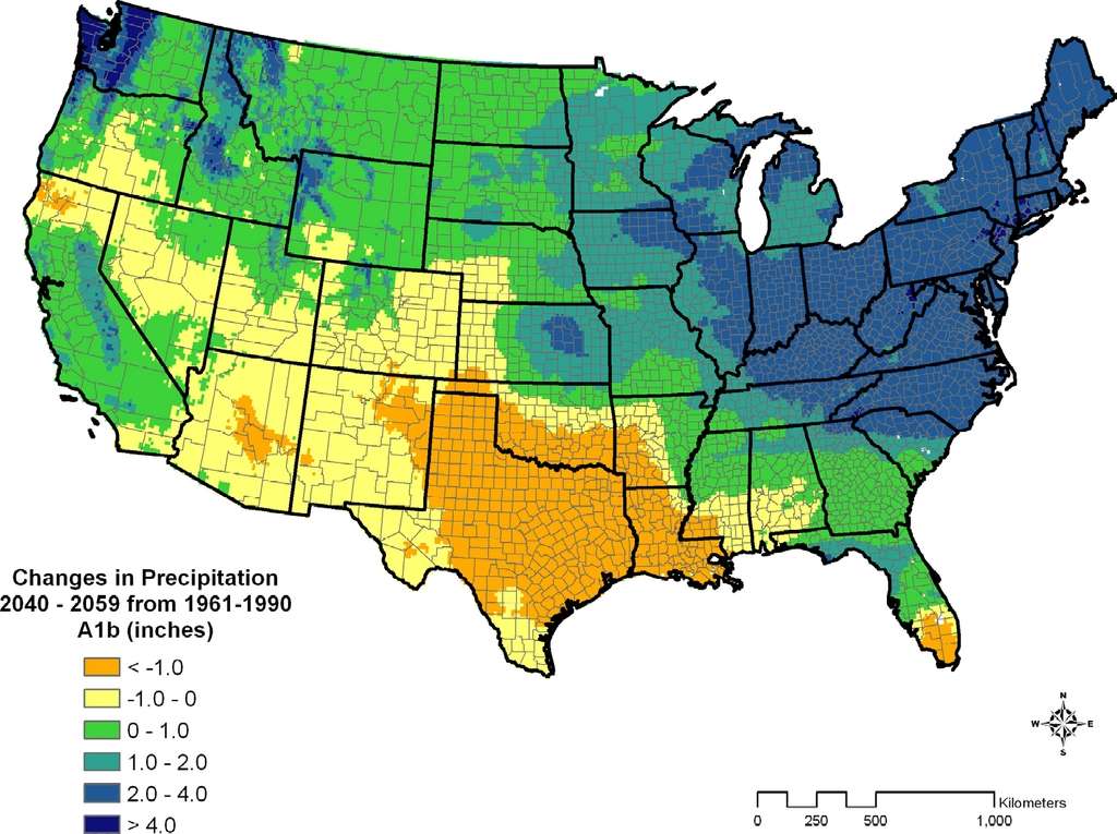
Drought will become increasingly common over the coming decades in Texas, and Oklahoma as the winter storm track moves north with climate change. Increasing levels of water vapor in the atmosphere caused by warming oceans will lead to increased rainfall across most of the U.S., but not in Texas, Louisiana, the southwest and the southern plains states.
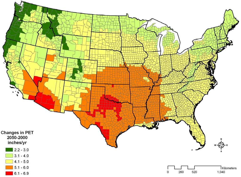
Direct evaporation from soil and transpiration from plants will increase rapidly over the coming 40 years in the southern plains and the southwest. Potential Evapotranspiration (PET) will increase to 5 to 7 inches per yer across Texas, Oklahoma and southern Arizona. These high evaporation rates will lead to desertification of north Texas and southwestern Oklahoma.
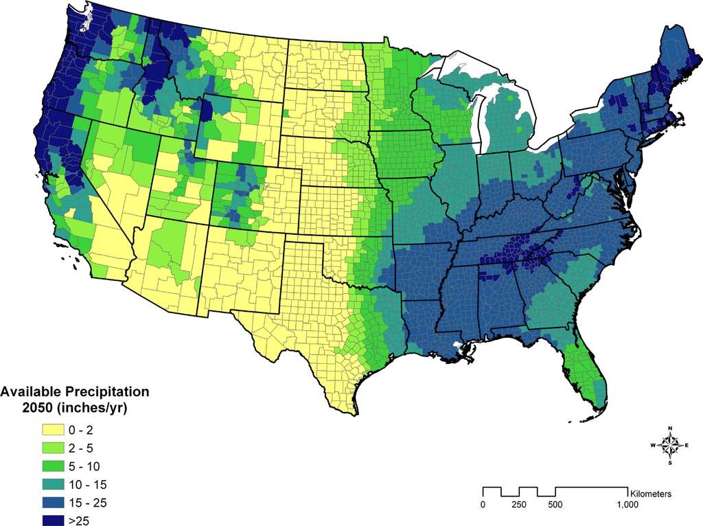
The hot dry climate will create a zone of zero to 2 inches of available precipitation - water available after evaporation for human use - in the plains from Texas to the Canadian border. The very high evaporation rates combined with very little precipitation in the winter months, as the storm track moves north, will create dust bowl conditions from Texas through the plains states.
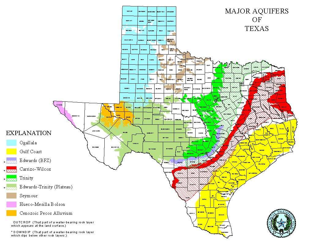
The water level of high plains aquifer also known as the Ogallala aquifer has already been drawn down across the high plains. Demands on ground water will increase, leading to greater aquifer draw downs across the plains and the southwest. The Edwards aquifer in Texas will be drawn down

Water is the most important factor affecting activities on the Great Plains. Most of the water used in the Great Plains comes from the High Plains aquifer (sometimes referred to by the name of its largest formation, the Ogallala aquifer), which stretches from South Dakota to Texas. The aquifer holds both current recharge from precipitation and so-called "ancient" water, water trapped by silt and soil washed down from the Rocky Mountains during the last ice age.
As population increased in the Great Plains and irrigation became widespread, annual water withdrawals began to outpace natural recharge.422 Today, an average of 19 billion gallons of groundwater are pumped from the aquifer each day. This water irrigates 13 million acres of land and provides drinking water to over 80 percent of the region’s population. Since 1950, aquifer water levels have dropped an average of 13 feet, equivalent to a 9 percent decrease in aquifer storage. In heavily irrigated parts of Texas, Oklahoma, and Kansas, reductions are much larger, from 100 feet to over 250 feet.
Projections of increasing temperatures, faster evaporation rates, and more sustained droughts brought on by climate change will only add more stress to overtaxed water sources. Current water use on the Great Plains is unsustainable, as the High Plains aquifer continues to be tapped faster than the rate of recharge.
Aquifers in far eastern Texas may be able to continue to meet water demand without large draw downs. Higher temperatures, higher evapotranspiration rates and decreased precipitation amounts will stress groundwater supplies across all of Texas except for the area near the Louisiana border.
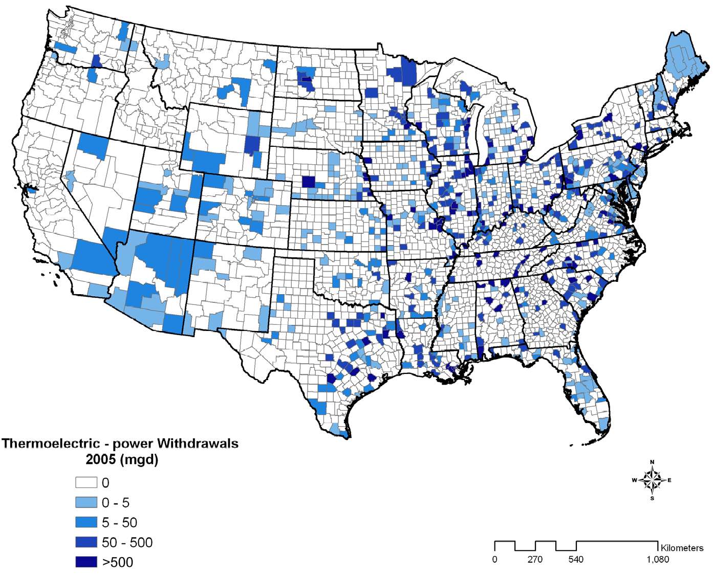
Conventional fossil fuel and nuclear power generation consumes large amounts of water to produce electricity. Power generation consumed 40% of U.S water consumption compared to 32% consumed by agriculture. Public supply and domestic consumption is under 15%.
Electric power generation is the largest consumer of water in the U.S.

Texas, the plains states, Arizona and Florida have committed a high percentage of available water supplies to conventional electric power generation. Further growth of conventional electric power will inevitably take from agricultural water supplies because agriculture depends on inexpensive water. With increasing demand for water and diminishing supply, the lowest cost users will be forced out.
Water mining from aquifers will grow. The rates of draw down will increase with climate change as far more water is consumed than recharged. The water use will not be sustainable. There will not be sufficient water to continue to support agricultural, industrial and domestic activities.
The Colorado River, which supplies water to much of the southwest, is already fully used for water supplies. The Rio Grand and other rivers that supply water to the southwest and the great plains will have less water due to climate change, combined with more demand for the water as temperatures rise. The Colorado River mouth is a hot, dry, dusty salt pan. More rivers will dry up with climate change.
Boat on the Colorado River mouth in Baja California
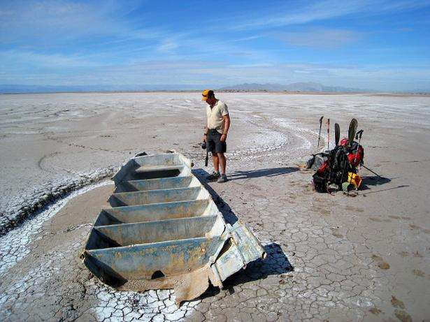 Photo credit: Jonathan Waterman
This is what we face if we continue with business as usual according to a study just released by the NRDC, prepared by Tetra Tech.Hi res PDF
NRDC's brief summary of the report with links.
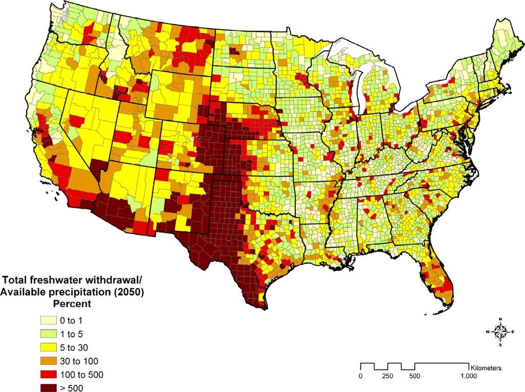
The water demand projections in this work are based on business-as-usual trends in growth, particularly of population and energy demand, and renewable water supply projections are based on the average results of an ensemble of sixteen established climate models. The analysis is performed using annual water use data at the U.S. county level, and using global climate model outputs for temperature and precipitation, both projected 20-40 years into the future. The analysis provides a national-scale evaluation of the results of changing water demand and supply, and helps identify regions that are most susceptible to climate change.
The county-by-county report tells, on a county-by-county level, a part of a global story of massive climate change involving the warming and drying of enormous areas of productive cropland in the subtropics and temperate zones. Desertification will take place from the southwestern U.S. to southern Europe and north Africa to eastern South America and western Australia.

It will be an irreversible global catastrophe if we continue business as usual.
