Crosspost
It's hard to give too much actual significance to a special election victory in a nominally Republican seat. While it may have few immediate political ramifications (one seat extra in Congress, and Democrats have another vulnerable seat to defend in a few months), the symbolic meaning is huge.
To illustrate the magnitude of this victory, it's useful to plot it on a map.
Softspoken nuclear physicist Bill Foster (D) defeated dairy farmer Jim Oberweis (R) on Saturday to represent Illinois' 14th. Illinois' 14th District, once represented by Dennis Hastert, the longest-serving Republican* Speaker of the House in history, and also once represented by Joseph Cannon, whose record Hastert broke; a district that sent to Washington two of the most powerful Republicans ever to serve as Speaker of the House, has just elected a mild-mannered scientist, who even worse, is a Democrat.
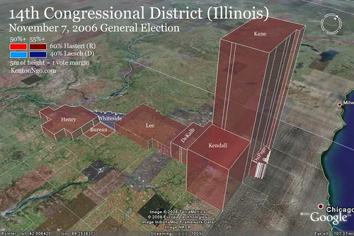
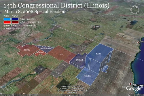
The color of each county corresponds to the winner, and its shade the percentage. However, county-by-county analysis is always a game of margins--so we've added a third dimension. The height of each county represents the raw margin the winner assembled. A short height means a small margin, a large height means a large one. Counties that lie flat may have a huge population, but both candidates fought it to a stalemate. Using the third dimension we can more easily see where each candidate's base was.
First we'll look at the 2006 map, when Dennis Hastert won re-election by 20 points. The bulk of the district's population is in Kane County, a suburb of Chicago. Note the towering margins by which Hastert pummeled Laesch. When we flip to the 2008 map (the scale is the same, but remember, it's a special election--lower turnout means smaller margins), we see that while the western end of the district remained virtually unchanged, the farther east you go the more Foster was able to gain ground over his predecessor. He was able to pull even or nearly even in rural Lee and suburban Kendall and DuPage counties, setting the stage for big wins in DeKalb and Kane counties to put him over the top. The swing was most evident in Kane County--the bulk of Foster's margin there came from the city of Aurora in the southeastern portion.
For your browsing pleasure, I've uploaded the source KMZ files I used to generate these in Google Earth. You can rotate, fly around, and add layers to your heart's content. Please note that in order to get a fairer picture, each polygon's height is coded to be absolute to sea level, not to ground level, so to get the most accurate perspective turn terrain view off.
2006 results
2008 results
*Thanks ILDem
