Today, Puerto Rico voted and Hillary Clinton won by a wide margin. However, this was not an ordinary contest. For one thing, Puerto Rico is not a state. For another, the traditional Republican and Democratic Parties of the mainland are very secondary presences. And finally, unlike the states, Puerto Rico is a completely Spanish-speaking territory.
These factors an others made for an interesting set of results. Here's a map of Puerto Rico using the scale below with Clinton as Red and Obama as blue:

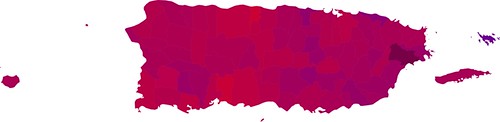
If you're wondering what the dark region is, that's Naguabo, where there were an abnormally high number of blank ballots. The only municipality won by Obama was Culebra, which is the small archipelego to the east of the main island.
I also prepared a weighted version of the map on the same scale that I used for my last batch, with brighter areas having a higher voter density:
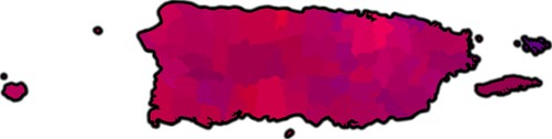
As you can see, unlike most of the mainland, Hillary Clinton's stronghold was in the biggest urban area of the state: San Juan, the capital.
One of the more interesting dimensions of this race was shown in the CNN exit poll. Of the 59% who said that Puerto Rico should be a state, 81% voted for Clinton, while the vote split 50%-50% among those who thought that it should remain a commonwealth (territory).
So, I decided to see if this would be reflected geographically, by mapping the results of the 1998 plebecite, the most recent referendum on statehood. The options on that plebecite were:
Estado Libre Asociado "Territorial" - "Territorial" Commonwealth
Libre Asociación - Free Association
Independencia - Independence
Estadidad - Statehood
Ninguna de las anteriores - None of the above
Surprisingly enough, the winner was "Ninguna de las anteriores" (None of the above) with 50.3% of the vote. In close second was "Estadidad" (Statehood) with 46.5% of the vote, and in a distant third was Independencia (Independence) with 2.5% of the vote.
Because of the exit poll data, I thought that there might be a good correlation between the vote ratios for the Obama-Clinton race and the ratios of voters voting for statehood versus "None of the above". However, looking at the map, the correlation isn't clear:
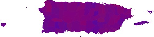
Now, the lack of clear correlation may simply be a product of the fact that many Puerto Ricans stayed home. The Democratic Party has a greater stronghold in Kansas than it does in Puerto Rico and despite the heavy media attention, not many people voted. Oregon, which holds 52 pledged delegates, had 1.6 times the turnout of Puerto Rico, which holds 55 pledged delegates.
I suspect that a good portion of the pro-commonwealth crowd stayed home. After all, why involve yourself with mainland presidential politics when you don't favor the statehood that would allow you to vote in the general election?
Color swaps
Ratio map


Weighted map


Plebecite map


