Never in historic records has a tropical storm formed so far south and east in the north Atlantic this late in the season. Never. And Tomas has the potential to become a major hurricane in the Caribbean, possibly threatening Haiti, Jamaica or Cuba next week.
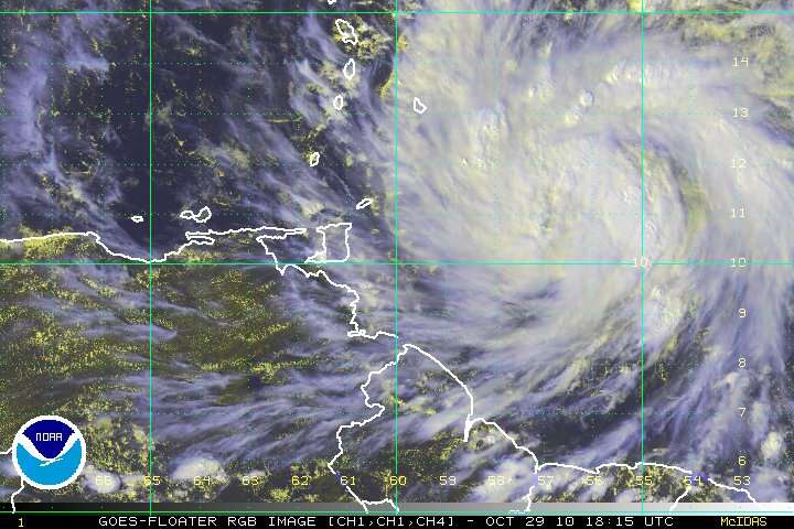
Tropical Storm Tomas forms Friday afternoon north of South America in the tropical Atlantic.
8pm EST Update: Tomas strengthening rapidly
AIR FORCE RECONNAISSANCE DATA INDICATE THAT MAXIMUM SUSTAINED WINDS
HAVE INCREASED TO NEAR 60 MPH...95 KM/HR...WITH HIGHER GUSTS. SOME
ADDITIONAL STRENGTHENING IS FORECAST DURING THE NEXT 48 HOURS...AND
TOMAS COULD BECOME A HURRICANE BY LATE SATURDAY.
TROPICAL STORM FORCE WINDS EXTEND OUTWARD UP TO 105 MILES...165 KM
FROM THE CENTER.
THE LATEST MINIMUM CENTRAL PRESSURE ESTIMATED BY RECONNAISSANCE
AIRCRAFT WAS 999 MB...29.50 INCHES.
Tomas looks like a mid-September tropical storm threatening to wreak havoc on the Caribbean with wind speeds forecast to reach a category 3 level of 100kts = 115mph. Tomas has formed off of a huge tropical wave offshore of South America, in the same unusual location as many of the August and September hurricanes of 2005.
________________________________________________________________________
UPDATE 2
Tomas approaching hurricane strength at 11PM AST
AS MENTIONED IN THE 0000 UTC SPECIAL ADVISORY...THE AIR FORCE
RECONNAISSANCE AIRCRAFT REPORTED A MAXIMUM FLIGHT-LEVEL WIND OF 61
KT AND SFMR MEASUREMENTS BETWEEN 50-55 KT...ALBEIT IN SOME HEAVY
RAIN...ON THE LAST PASS THROUGH THE CENTER. DEEP CONVECTION HAS
CONTINUED TO INCREASE SINCE THAT TIME WITH A PROMINENT BAND FORMING
OVER THE WESTERN SEMICIRCLE...SO THE INITIAL INTENSITY IS BEING
RAISED TO 55 KT ON THIS ADVISORY.
Dr. Jeff Masters provides more details on this unprecedented storm.
The formation of a tropical storm so far south and east this late in the season is unprecedented in the historical record; no named storm has ever been present east of the Lesser Antilles (60°W) and south of 12°N latitude so late in the year. Hurricane Six of 1896 came close--it was also a tropical storm south of 12°N and east of 60°W on October 29, but nine hours earlier in the day. That storm recurved to the north and missed the Lesser Antilles. Tomas' track through the southern Lesser Antilles so late in the year is unprecedented. There have been only two other tropical storms that formed after October 15 south of 12°N and east of 60°W: Hurricane Jose, which was a tropical storm in that region on October 18, 1999, and Tropical Storm Nicolas, on October 16, 2003. Tomas most reminds me of Hurricane Joan of 1988, which was a tropical storm on October 14 near Tomas' current location, and later strengthened into a Category 4 hurricane that hit Nicaragua.
Another unusual aspect of Tomas' formation is that we now have two simultaneous named storms in the Atlantic Ocean on October 29. There have been only four hurricane seasons since 1851 that have had two simultaneous named storms later in the year. The record was set way back in 1887, when Hurricane Eighteen and Tropical Storm Nineteen were both active on December 8. There were three years that had simultaneous November named storms: 1932, 1961, and 2001.
________________________________________________________________________
Tomas has became much better organized today, but was not fully aligned from bottom to top at 5pm EST. When Tomas becomes vertically aligned, rapid development will be possible because wind shear is low and the is exceptionally warm.
The NHC shouts (all caps theirs).
RECON AND SATELLITE DATA INDICATE THE LOW-LEVEL AND UPPER-LEVEL CIRCULATIONS ARE NOT YET VERTICALLY ALIGNED...WHICH SHOULD RESULT IN ONLY SLOW INTENSIFICATION IN THE NEAR TERM. HOWEVER...WITH A CENTRAL PRESSURE OF 998 MB...VERY MOIST MID-LEVELS...AND LOW VERTICAL SHEAR...IT WOULD NOT TAKE MUCH FOR TOMAS TO INTENSIFY AT A FASTER THAN NORMAL RATE. WHILE NOT EXPLICITLY INDICATING RAPID INTENSIFICATION...THE OFFICIAL INTENSITY FORECAST REFLECTS THESE FAVORABLE ENVIRONMENTAL CONDITIONS...AND IS ABOVE THE SHIPS/LGEM INTENSITY MODEL GUIDANCE.
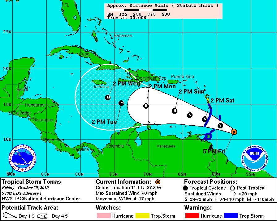
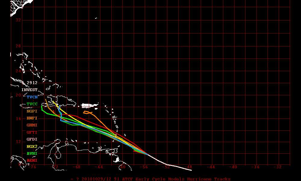
FORECAST POSITIONS AND MAX WINDS
INITIAL 29/2100Z 11.1N 57.5W 35 KT
12HR VT 30/0600Z 12.0N 59.5W 40 KT
24HR VT 30/1800Z 12.9N 61.8W 50 KT
36HR VT 31/0600Z 13.5N 64.0W 60 KT
48HR VT 31/1800Z 14.1N 66.2W 70 KT
72HR VT 01/1800Z 14.8N 70.4W 90 KT
96HR VT 02/1800Z 15.2N 74.0W 100 KT
120HR VT 03/1800Z 16.0N 76.0W 100 KT
Dr. Jeff Masters, hurricane expert (former hurricane hunter), reported the developing news from the National Hurricane Center yesterday evening.
Potentially dangerous 91L approaching South America and Lesser Antilles
A very impressive tropical wave (Invest 91L), about 350 miles east-southeast of the southernmost Lesser Antilles Islands, is headed west-northwest towards the islands at 15 - 20 mph. In discussions I had with hurricane experts at NHC and NOAA's Hurricane Research Division yesterday, it was widely agreed that this system was unusually large and well-organized for this time of year--something one would expect to see in early September, but not late October. The historical Atlantic hurricane data base shows no cases where a tropical depression has formed so far south and east so late in the year. "Ominous" and "unprecedented" were a few of the adjectives I heard used to describe 91L, and this system has the potential to be a dangerous storm for the islands of the eastern and central Caribbean.
Near record warmth in the tropical Atlantic fueled the formation of Tropical Storm Tom.
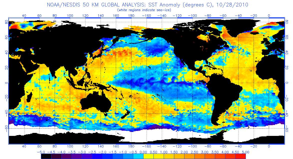
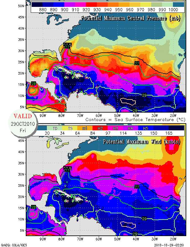
Tropical Atlantic water temperatures are warm enough to support a category 5 hurricane under ideal atmospheric conditions despite the calendar date.
Storm track forecasts are very uncertain for the Caribbean because errors are large for all forecasts more than 3 days ahead, but Haiti and Jamaica could be threatened. There is no threat to the continental U.S. at this time.
Tom's track model run based on Friday morning EST data (12Z)
Climate change is not increasing the number of tropical storms globally, but it may be increasing the area of the Atlantic basin where the water is warm enough to support tropical storms. It may also be extending the length of the hurricane season in the fall. Because satellites have made identification of storms in the open ocean easier than before satellites observed storms, hurricane specialists debate these issues.
What we know for certain is that heat is being added to the Atlantic ocean by global warming. That heat has the potential to produce more water vapor to support stronger storms.
While unprecedented weather happens more and more frequently, Republican politicians become more and more adamant in their denial of reality. Human activity is changing the climate, loading the dice towards more record high temperatures and more extreme storms.
Vote like people's lives depend on it. They do.
Addendum for storm geeks:
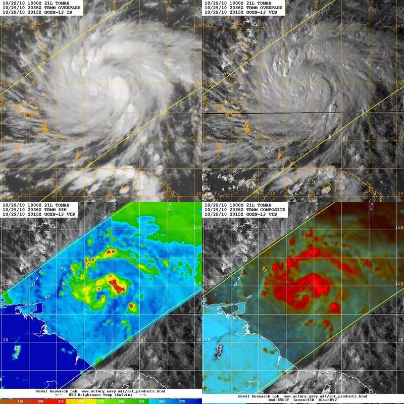
Navy microwave TMI imagery shows the core of Thomas developing early this evening.
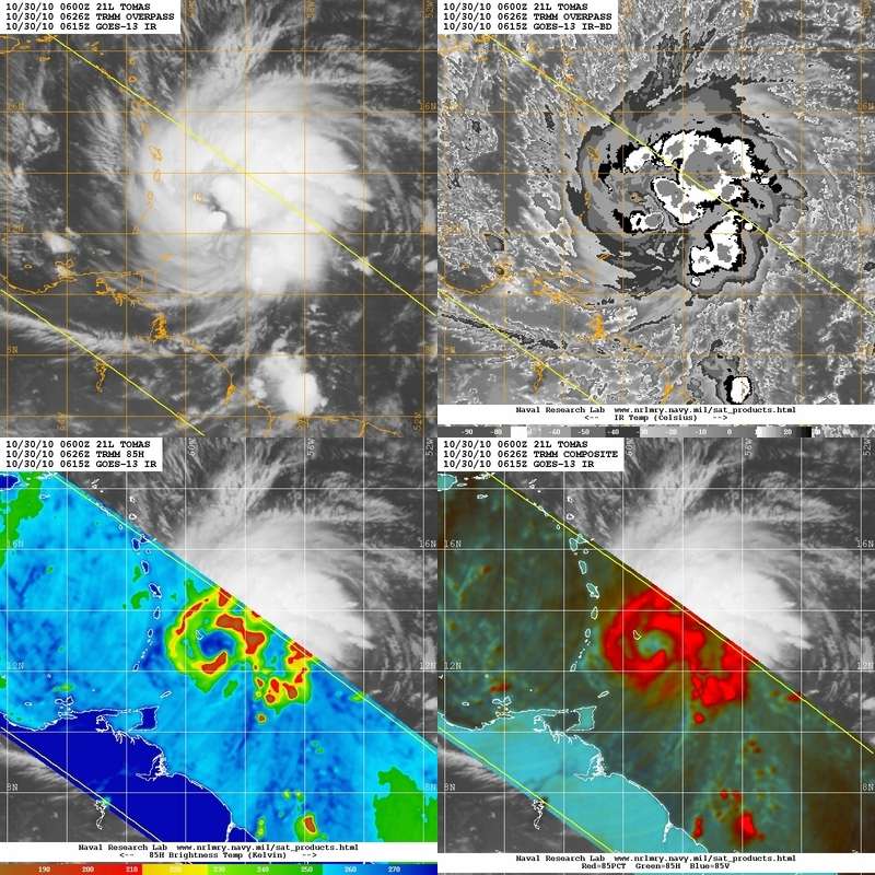
Update 3: 5am October 30
At 5am Tomas' maximum winds were 60knots, 5 knots (6mph) under minimum hurricane strength. An eye is beginning to form, visible on U.S. Navy microwave imagery.
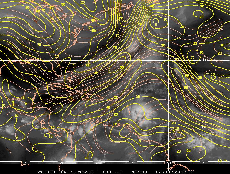
University of Wisconsin shear estimates show that wind shear may be increasing across Tomas. 15 knots of southerly shear across were estimated to be affecting Tomas early this morning. Southwesterly wind shear may slow the development of Tomas. However, the NHC is still predicting Tomas to reach major hurricane status in 4 days
NHC discussion 5am this morning, October 30.
THE SATELLITE PRESENTATION OF TOMAS HAS IMPROVED OVERNIGHT. AN
EARLIER GAP IN THE DEEP CONVECTION NEAR THE CENTER HAS FILLED IN
...AND THE OUTFLOW REMAINS EXCELLENT. ALSO...IMAGERY FROM THE RADAR
ON MARTINIQUE AND A 0624 UTC TRMM PASS SUGGEST THAT AN EYEWALL
MAY BE FORMING. BASED ON THESE TRENDS...THE INITIAL INTENSITY IS
RAISED TO 60 KT. AN AIR FORCE RESERVE HURRICANE HUNTER AIRCRAFT IS
SCHEDULED TO INVESTIGATE TOMAS LATER THIS MORNING TO GET BETTER
INFORMATION ON THE STRUCTURE AND INTENSITY OF THE CYCLONE. DURING
THE NEXT DAY OR SO...CONDITIONS APPEAR FAVORABLE FOR CONTINUED
INTENSIFICATION. IN FACT...THE SHIPS MODEL RAPID INTENSITY INDEX
SHOWS A NEARLY 60 PERCENT CHANCE OF A 25-KT INCREASE IN 24 HOURS.
BEYOND THAT TIME...THE SHIPS MODEL...BASED ON GFS MODEL FIELDS...
SHOWS AN INCREASE IN SOUTHWESTERLY SHEAR...WHICH SHOULD SLOW THE
RATE OF INTENSIFICATION SOMEWHAT. AFTER 72 HOURS...THE SHEAR MAY
RELAX AND ALLOW FOR FURTHER INTENSIFICATION. THE NEW OFFICIAL
FORECAST REFLECTS THIS THINKING AND IS ABOVE ALL OF THE RELIABLE
INTENSITY MODELS THROUGH THE PERIOD.
