You are in the current BP disaster ROV, number 112. Number 111 is here.
Please DO NOT Rec this diary, rather REC THE MOTHERSHIP instead. She needs your love to stay afloat.
Please be kind to kossacks with bandwidth issues. Please do not post images or videos. Again, many thanks for this.
PLEASE visit Crashing Vor and Pam LaPier's diaries to find out how you can help the Gulf now and in the future. We don't have to be idle! And thanks to Crashing Vor and Pam LaPier for working on this!
For a description of the mothership/ROV liveblogging process, check out this thread.
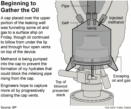
BP put up a video explaining the LMRP procedure and the future plans.
Go to the Deepwater Horizon Data Summary for a wealth of actual data from the Department of Energy.
The BOP and pressure drawings are viewable here. The CAD drawings come highly recommended by the techies among us. h/t Claudius Bombarnac.
Breaking News and new links:
This is what BP DOES NOT WANT YOU TO SEE. The following images are guaranteed to make you SICK AT HEART.
These images are not for the faint of heart - DO NOT VIEW THEM LIGHTLY.
Really, I mean it. Hold somebody's hand. Grab a tissue.
A brief reference guide to nicknames you may see in the ROV diaries:
- Gertrude, aka Gerty: the oil volcano
- Lizzy: the diamond saw cutter
- Clampy: the cute ROV
- Crunchy: 30 ft shear. bit the pipe, now a movie star
- Wanda: the dispersant sprayer
- laundry basket: yellow thing that brings things up and down
- Thingy: those things, you know, those things
- Shiny Thing: those really neat things
- Ms. Blanche Flo, aka Blanche, aka Flo: the manifold thingy
cosmic debris put together a comprehensive list of links on oil health and safety info:
Thanks to dov12348 for publishing a diary on Oil Terminology.
Here is a tutorial on the sources of pressure on the well
H/t to Pluto for finding this:
The official casing configuration under the wellhead.
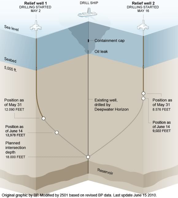
Images giving a rough idea of what's in place now and status of the kill wells
The video feeds we are watching:
==== ROV Feeds =====
44287/44668 - OceanInterventionROV1
44838/45135 - OceanInterventionROV2
46566/54013 - Viking_Poseidon_ROV1
55030/56646 - Viking_Poseidon_ROV2
31499/31500 - Boa_Deep_C_ROV_1
22458/23729 - Boa_Deep_C_ROV_2
45685/49182 - Skandi_ROV1 (BP player shows wrong feed)
45683/45684 - Skandi_ROV2
47175/21144 - Enterprise_ROV_1
21145/21327 - Enterprise_ROV_2
37235/37270 - Q4000_ROV1
35523/35624 - Q4000_ROV2
Possibly outdated or redundant links (from The Oil Drum):
46245 - BP "Official" #1 (primary)
46260 - BP "Official" #2 (secondary)
46661 - BP mystery feed #1
46663 - BP mystery feed #2
Restricted to web browser based viewing:
CNN Video Streams Note: multi-view is sometimes unavailable.
PBS (fewer security issues than some others)
BP videos Links to all available live feeds from BP.
WKRG - Mobile/Pensacola (Contains link for an iPhone app at the bottom.)
ABC 7 Chicago Live Video Multiple ROV Camera Views (h/t to temptxan for the great find).
Multiple stream feeds (hard on browser/bandwidth):
The best multi-view feed Be patient as load time may take a bit.
Markey's multi-view page
Lusty's multi-feed page
Vote For America's awesome clickable multi-view Courtesy of one of our very own Kossacks.
A multi-view Contains feeds from BP, C-SPAN-2, WKRG, and PBS
High-def video feeds
See this thread for more info on using video feeds and on linking to video feeds.
Again, to keep bandwidth down please do not post images or videos.
Links, courtesy of several Kossacks
- GeoPlatform - Gulf Response: Mapping the Response to BP Oil Spill in the Gulf of Mexico
- BP may lose US oil leases, contracts as Gulf spill punishment
- Florida closes 23 miles of coastline to fishing
- International Bird Rescue Research Center: Info on bird survival rates
- Kent Wells' technical update, June 10, 2010
- Summarized tally of affected wildlife
- BP plans to suspend shareholder dividend amid oil spill
- Huge federal Gulf recovery act planned
- dov12348's oil toxicity links
- National Science Foundation rapid response research grants for Gulf oil spill research
- Rolling Stone: The spill, the scandal, and the president
- First oil reaches Florida inland waterways
- Another Gulf Oil Spill: Well near Deepwater Horizon has leaked since at least April 30
- White House endorses unlimited liability cap for oil spillers
- Lab tests confirm underwater layers of oil
- US Fish & Wildlife Service Deepwater Horizon Oil Spill Response h/t to CindyMax Left side of page has "Daily Wildlife Collection Reports" that details wildlife found oiled, alive, deceased, and/or released.
- Visualize the spill
- Nola.com
- dov12348's Ocean currents, wind currents, and hurricane links
- World newspapers oil section
- The Oil Drum
- Oil & Gas Journal
- Offshore Magazine
- Petroleum News
- Your Oil and Gas News
- World Oil
- Administration response to spill.
- Donate to SkyTruth here. SkyTruth helps environmental NGOs use remote sensing (pictures taken from space) and digital mapping to improve their scientific credibility, conservation decision making, communications and public outreach.
- Images of the Oilpacalypse, from Tomtech.
- Visit the Oil Spill Crisis Map to see where oil, mousse, tar balls, and eau de crude have been reported on the Gulf coast.
- The BP Deepwater Horizon Unified Command official website. Wherein you can read latest post warning of employment scams associated with the event and much more from the folks handling this.
- Timeline of response here.
- Timeline of the Event from April 20th being maintained by blogroots.
- Department of Energy BP Deepwater Horizon Spill site updates.
- Bit Tooth Energy blog (technical discussions) by the famed Heading Out, well known key poster on The Oil Drum blog site.
- Department of Interior BP Deepwater Horizon Response site provides updates, reports, data, links to pictures, etc.
- Rigzone for specific disaster news and news about the offshore industry, in general.
- BP Deepwater Horizon Oil Spill Quantitative Data - from whitis
- Courtesy of profgoose here is a list of links from The Oil Drum links on newer developments, etc
- Maritime ship tracking -- courtesy of johnsonwax
- U.S. begins criminal investigation into oil spil
- NOAA Spill tracking site
- ERMA: Environmental Response Management Application
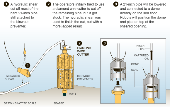
- BP has a good diagram of the cutting process that partially succeeded
- Documents show BP chose a less-expensive, less-reliable method for completing well in Gulf oil spill
- Norway freezes drilling in new deepwater blocks
- Worker on rig saw it coming
- BP doesn't want photos of dead animals
- Map of things on the sea floor there.
- Calculator for distance from BOP.
--------------
About ninety years ago, an island began to emerge in the pass between Ship and Horn in the Mississippi Sound. Originally, the island was called "Dog Key," and the pass became known as "Dog Key Pass." By 1924, the island was about two miles long and covered in sea oats (Uniola paniculata). "Dog Key" wasn't romantic enough for the Midwestern developers who brought their money to spend on the coast, and they re-christened the island the "Isle of Caprice," because of its rather capricious development.
Dog Key's artesian springs provided fresh water to fishermen, and during Prohibition the island became a bootlegger's delight. Realizing the potential of a prohibition-era resort 12 miles outside the any prohibition-enforcing lawman's reach, Colonel Jack Apperson, Walter Hunt, and Arbeau Caillavet (for whom Caillavet street in Biloxi was named) financed construction of the Isle of Caprice Hotel and Resort.
The most proper of coast ladies and gentlemen found the Isle of Caprice and its gaming establishment the height of society and frequented the casino there. 75-cent tickets to the ferry were sold at the L&N Depot, and tourists from New Orleans and Mobile were often found within hours of their arrival emptying their pockets at the faro tables on Caprice.
However empty coast society found their pockets at the end of a run on Caprice, the ladies often left with their bags full of sea oats, which were very popular as a millinery adornment. Little did they know that the lovely leggy grasses they so enjoyed were part of what kept Caprice together. Wind and current conspired to eat away the little island, and by 1931, it was nothing more than a sand bar.
In 1992, when the boats came to Biloxi (Language lesson - "the boats" refers to casinos down home, ie: "Y'all wanna go to the boats for Sunday brunch?") we got one called the "Isle of Capri". The Capri is at the foot of the Ocean Springs bridge, and it sits a little west and 12 miles north of its cousin. I couldn't help but think, at the tender age of 12, that naming the casino something so similar to the island that washed away wasn't well thought out by Biloxi developers. But, the Isle's still there, serving sub-par food and offering better than average odds to locals. Sometimes I find myself wishing we could pull up enough ... whatever... to have the new Isle wash away: its garish purple and coral facade would be far more charming if it were covered in sea oats.
--------------
Previous liveblog ROV diaries:
BP Oilpocalypse Liveblog ROV 111 - yawnimawke
BP Oilpocalypse Liveblog ROV 110 - politik
BP Oilpocalypse Liveblog ROV 109 - cosmic debris
BP Oilpocalypse Liveblog ROV 108 -Yasuragi
BP Oilpocalypse Liveblog ROV 107 - Wee Mama
BP Oilpocalypse Liveblog ROV 106 - rubyr
BP Oilpocalypse Liveblog ROV 105 - khowell
BP Oilpocalypse Liveblog ROV 104 - gchaucer2
BP Oilpocalypse Liveblog ROV 103 - Garrett
BP Oilpocalypse Liveblog ROV 102 - conchita
BP Oilpocalypse Liveblog ROV 101 - khowell
BP Oilpocalypse Liveblog ROV 100: Thanks to the crew and remember! - Tomtech
...
For a more complete list of Liveblog diaries, see the current mothership.
Bandwidth Warning: NO IMAGES and NO VIDEOS. Readers who are on DIALUP will thank you!
