We've seen maps of possible Republican gerrymanders and hypothetical Democratic gerrymanders. At one point someone said they'd like to see a neutral map, so this is attempt to simulate what a court might do. I tried to make compact districts that keep cities, counties, and metro areas together and to keep a majority-black district in the Cleveland area.
The map:
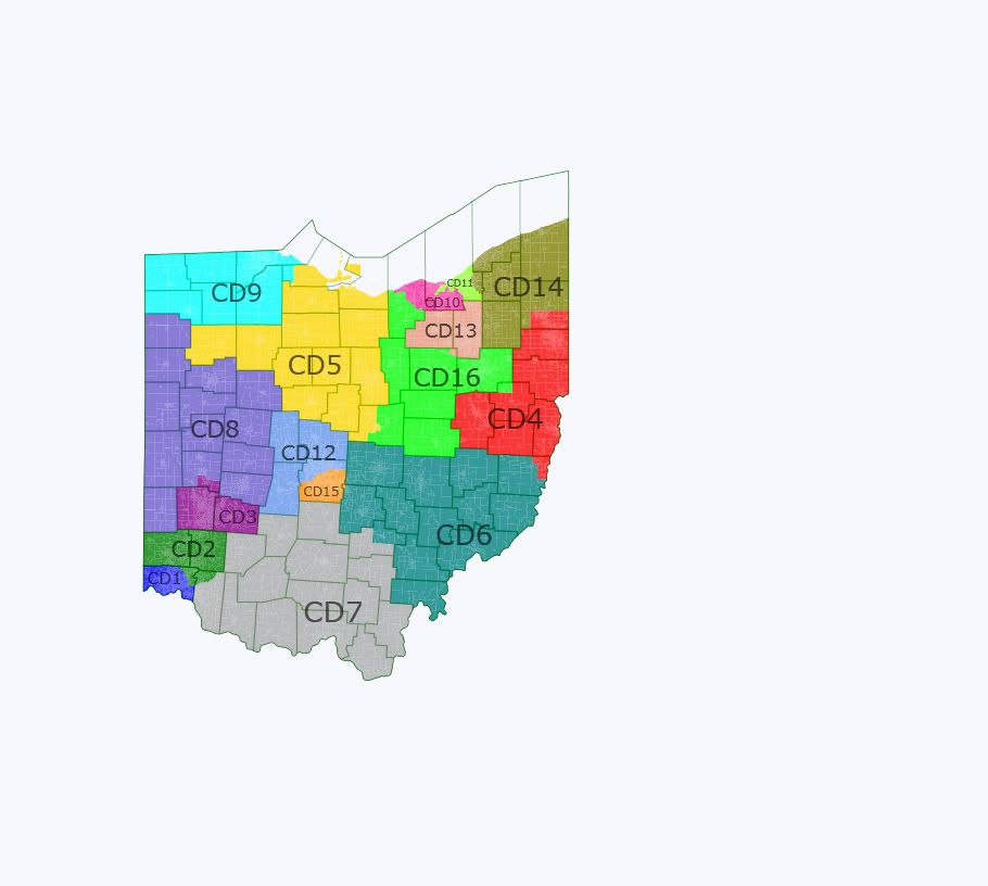
OH1 (blue): Hamilton county is slightly too big for one district, so it loses its northeast corner. D+1.5
OH2 (green): I tried to make a pure Cincinnati-suburbs district, but it messed up the Dayton district in a big way so OH2 ends up with Butler and Warren counties plus enough of Hamilton and Clermont to fill up. R+17.3
OH3 (purple): I'm not familiar with southwest Ohio and the “border” between the Cincinnati and Dayton areas isn't immediately obvious. The “Dayton” district has Montgomery and Greene counties plus a chunk of Miami. R+4.0
OH4 (red): In spirit this is the old OH17, which now has to go south to fill up. It's ancestrally VERY Democratic (6 points more than the new Columbus sink!) but has been trending red at the national level. D+4.0
OH5 (yellow): North-central district with no real anchor. I think the biggest city is Mansfield. R+8.5
OH6 (teal): I really struggled with the two southern Ohio districts and eventually decided that it was ok to have them both come up to the Columbus exurbs. R+7.8
OH7 (gray): This district is clean and compact but unfortunately goes from Cincinnati to Columbus. R+13.6
OH8 (blue-gray): A sprawling rural western Ohio district. It's r-e-d. R+15.5
OH9 (toothpaste blue): Logically the Toledo district would pick up the rural (and strangely blue-trending) northwest corner instead of snaking along Lake Erie. D+5.4
OH10 (pink): The “white” Cleveland district has to move west to pick up Lorain and Elyria. A Dem should win this, but Kucinich would get his clock cleaned. D+1.9
OH11 (pea soup green): It is not possible to draw a compact majority-black district that respects communities of interest. It is possible to draw a compact plurality-black district that respects communities of interest. This east Cuyahoga district has a 47.5% black voting age population and an overall 50.0% black population. At D+29.2 it makes my OH2 look competitive.
OH12 (light blue): Columbus' northern and western suburbs and exurbs. I did not try to follow city lines in Franklin county because it's a fool's errand. R+5.5
OH13 (pink-gray): This Akron-based district has all of Summit and Medina counties plus a small piece of Wayne and it's competitive. D+1.8
OH14 (olive): The northeast corner district doesn't change much. R+2.0
OH15 (orange): Basically the southern 2/3 of Franklin county and holy hell is this thing blue. D+12.0
OH16 (garden hose green): The Canton-based district has to curve around and pick up suburban and exurban areas of Lorain county because they wouldn't fit anywhere else. R+4.4
So what do we have here? By PVI it's 9R-7D but many of these are actually swing districts. OH2, OH5, OH6, OH7, and OH8 would likely be red all decade, and OH11 and OH15 blue. OH9 would likewise stay blue unless something very strange happened: it has a higher Dem PVI than any Republican-held district except for Bob Dold!'s with its favorite-son-distorted D+6. Marcy Kaptur is an archetypal beer-track Dem and would have absolutely no trouble holding it all decade. OH12 would be fairly safe R at the start of the decade, but would likely drift blue and be competitive by the end. That leaves 7 districts that should be competitive right away, although in practice Turner, Ryan, and LaTourette would be heavily favored to hold OH3, OH4, and OH14. The biggest battlegrounds would likely be OH1 in Cincinnati and OH10, OH13, and OH16 in the I-77 corridor. Basically I think this is 6R-3D-7S in 2012 and likely 5R-3D-8S by 2020.
Thoughts? I had all kinds of trouble trying to re-size the map in photobucket to fit the narrow screen on this site.
