A Levee has breached in Sawyer, ND
Mandatory evacuation for Sawyer, ND as of 11:30am June 25.
Text 'REDCROSS' to 90999 to donate $10.
American Red Cross
Minot Community Foundation
If you are a Ham radio operator the Red Cross in Minot needs your help! 3937mhz
Follow on twitter using #Minot, #Minotflood, and #Flooding.
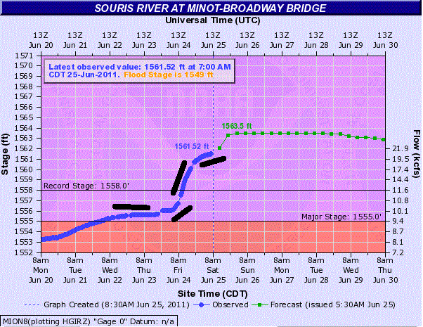
The Souris River is expected to crest at 15653 feet. (per NOAA page below the squiggle)
As of 7:00AM CDT on June 25, the Souris River is at 1561 feet.
Historical flood crest information (from NOAA):
(1) 1,558.00 ft on 01/01/1881
(2) 1,556.08 ft on 04/18/1976
(3) 1,555.40 ft on 04/20/1969
(4) 1,555.15 ft on 04/20/1904
(5) 1,544.06 ft on 04/12/1996
The good news: The rate of increase per the Souris River gauge has begun to slack off-or, for the math nerds, the slope is flattening:
The bad news:
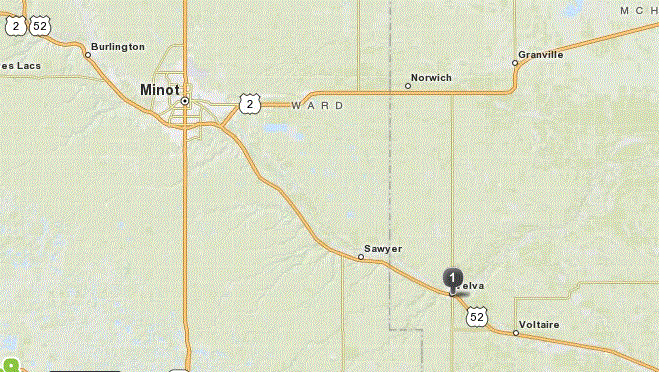
Levee breach in Sawyer, ND
Rapid water level rises expected in Velva and downstream
Good chance of severe thunderstorms this weekend
Latest weather.com story
Latest cnn.com story
Background: Minot, ND is a city of just over 40,000 people less than 60 miles south of the US/Canada border. This city was built at the junction of two major transcontinental railroad lines (BNSF and CP Rail-both have suspended operations in this area due to the flooding, which means Amtrak is hampered as well.)
Due to the Williston Basin oil boom, the housing supply is extremely tight-people are sleeping in their cars.
Here is a map of the town. Take a look at the river.
from mapquest
This flooding was predicted by NOAA back in March, but the timetable has accelerated dramatically due to substantial rain in Canada, which has had to release large volumes of water from the Rafferty and Alameda Reservoirs to prevent damage. That water has gone right into the Souris River, which flows south into the US, loops around, and heads back into Canada. (Yes, geography is weird there.) Usually Lake Darling Dam releases are timed to increase and decrease with area snowmelt, but water levels are increasing so fast they can no longer be controlled.
This event is expected to keep evacuees away from their homes for several weeks.
Evacuation information and assistance:
Please check road conditions before you try to drive anywhere! Many bridges and roads are unusable!
ND Road Conditions
Minot evacuation zones
Burlington evacuation zones
Ward County Flood information
Minot American Red Cross
FEMA disaster assistance FAQ
If people have damage they should call FEMA immediately at 1-877-212-0316 to start the process.
Souris River height tracking at NOAA
Interesting NOAA map showing topology and other communities in ND under threat
USGS Lake Darling Flood Monitor Page
Inundation maps-large file! loads slowly!
Corps of Engineers Minot levee review, undated
May 20 Article about rising water outflows
NEW LINK! Free topo and satellite maps!
The default is Mt Rainier-doesn't look like I can change it-but it's easy to use. Zoom out, use the arrow to move east, and zoom back in-you can trace the Souris River as it loops around ND and back into Canada.
Significant event timeline:
June 24
1:30pm Souris River is officially over record flood stage.
June 23
4:14pm Outflows from Lake Darling increased. Expected crest now 1565ft. Expanded evacuation areas to be announced. Broadway Bridge closed.
June 22
9:30am The Souris River begins to overflow levees in Minot.
11:00am The National Weather Service issues a flash flood warning after the water levels rise four feet in a brief period of time.
12:57pm Warning sirens for evacuation begin to sound, 5 hours early.
Kossacks Blog the Flood
noddem's photo diary
noddem lives in Burlington, ND-also under evacuation
RuralRoute's original diary on Minot, ND flooding
Other Media Resources:
yfrog photos by Minot resident
cbc.ca
PlainsDaily.com
Paul Douglas at startribune.com
kxmc livestream
weather.com Flood tracker
cnn.com story
local Minot media reports
Minot Daily News
KMOT
KFYRTV.com
A decent summary from the Washington Post
A review of flooding from the Canadian side, including the Souris River
26 communities in Saskatchewan are under some kind of flood surveillance
Results of google news search-lots of articles on both US and Canadian flood efforts
