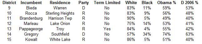
Back at SwingStateProject, I started what was going to be a series of diaries looking at redistricting the Michigan state legislature. Only the first diary in the series, looking at state house districts in Wayne County, got published before the switchover. Now that Dave's App has partisan data for Michigan (and has additional support for state legislative redistricting), I'm returning to the series with this look at the state senate.
Michigan has 38 state senate districts. The Republicans currently hold a 26-12 majority, having won four districts from the Democrats in 2010; the senate has been Republican-held since 1983. Michigan's redistricting standards frown on splitting counties and localities, so while the districts don't quite "draw themselves" as redistricting committee chair Pete Lund once claimed, there are significant limits to what can be done on the map. The map I've drawn below sacrifices a district or two back to the Democrats but should still lock in a solid majority for the Republicans for the duration of the plan.
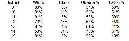
Notes: Ideal district size is 260,096. Allowed deviation is 5%, which is +/- 13,004. Displayed population data is from the 2010 census for all maps. Racial percentages are given for districts in the Detroit metro area and are based on voting age population. "Obama %" in charts below is Obama's share of the two-party vote. "D 2006 %" is the average Democratic share of the vote in the races for governor, secretary of state, and attorney general in 2006. The Republicans won two out of those three races. I generally assume that splitting the difference between those two numbers should you something close to a true underlying average.
I'm assuming that with state legislative districts readers could use some orientation as to the current state of affairs, so each section is going to present the current map before moving on to the remap. If you want to look at the whole current map, here's a link. (PDF)
Wayne County
Current Map
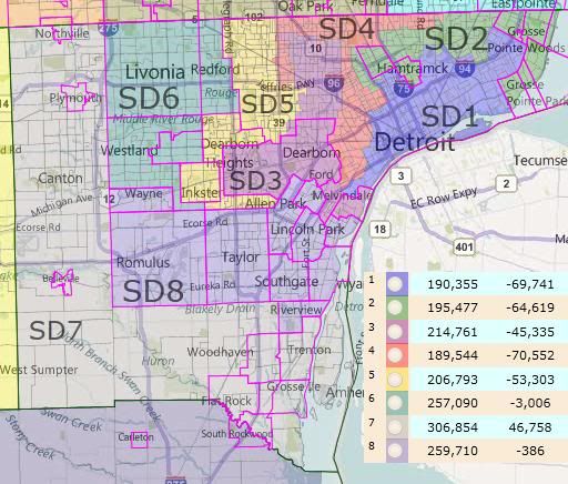
Note how dramatically underpopulated the five districts located wholly or partially in Detroit are. Even with Old-SD-07's significant gains, Wayne County is losing a district.
There are only a few things that are truly mysterious to me about the current map, statewide. The shape of Old-SD-04 is one of them.
Proposed Map
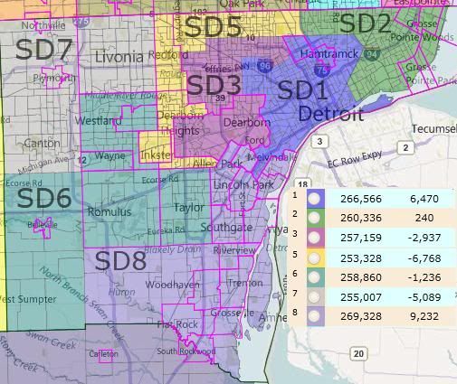
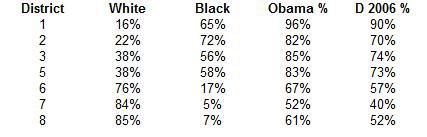
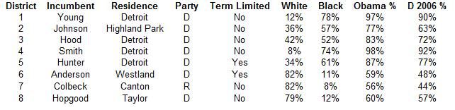
I eliminated Old-SD-04, the most underpopulated district, which you'll see relocated elsewhere in the state later. I don't know where any of the Detroit representatives live within the city, so I didn't take their individual welfare into account. (And I don't know if the Republicans would anyway.) New-SD-03 could swap Dearborn to New-SD-05 in exchange for that district's share of Detroit and still have two appropriately size districts. Following the redistricting guidelines' preference for non-splitting originally lead me to that result before I realized that axing another majority African-American district on top of the one lost to Detroit's population decline would run afoul of the VRA.
Old-SD-06 was originally intended to be a Republican district; they lost it in the 2006 elections. I don't think that they can reasonably expect to hold two districts in Wayne County anymore, so my proposed remap joins the most Republican parts of Old-SD-06 and Old-SD-07 into New-SD-07. New-SD-08 is a very communities-of-interest friendly Downriver district, although its incumbent Hapgood is being forced into New-SD-06.
Running tally: Democrats down one.
Oakland and Macomb Counties
Current Map
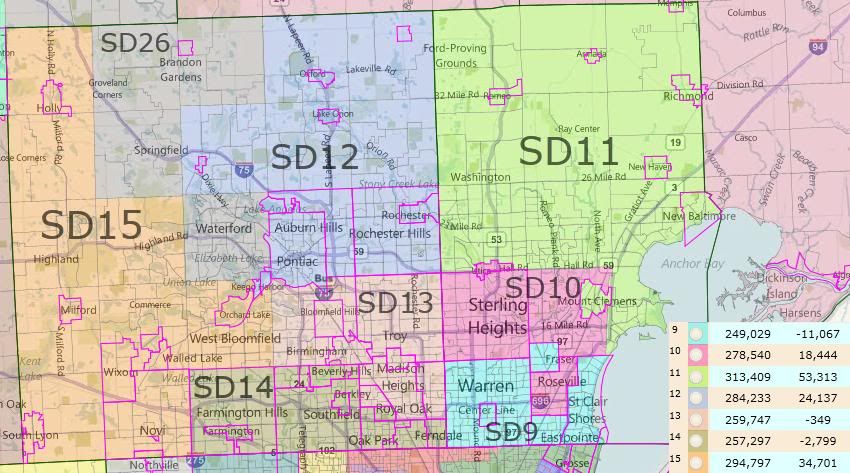
SD-26, in both incarnations, continues up into Genessee County, and will be dealt with there. Note the heavy overpopulation of northern Macomb and northern and western Oakland. This is dealt with by bringing New-SD-25 into Macomb from St. Clair County and reconfiguring New-SD-26 to be more Oakland-based than Genessee-based, as can be seen below.
Proposed Map
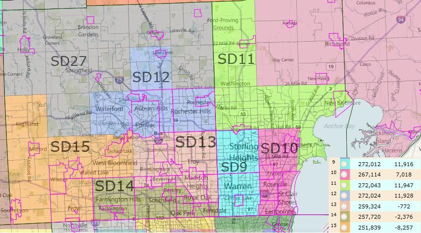
The gray district in northern Oakland is New-SD-26. I dragged the wrong label onto the image.
New-SD-09 and New-SD-10 switch orientations from east-west to north-south. This is bad for the Republicans, and in particular for Republican incumbent Rocca in Old-SD-10, who gets thrown in with Democratic incumbent Bieda from Old-SD-09. But it can't be helped. I couldn't find any other arrangement of cities that could be added to Warren and its enclave Center Line that would make a valid district. Old-SD-10 is one of the districts that the 2010 wave gave to the Republicans. Even if the lines were able to stay the same, there's a good chance they'd have lost it in 2014 anyway. Democrats regain, in a way, the seat they lost in Detroit. All other incumbents are preserved in their districts.
New-SD-13 and New-SD-14 stay more or less in place, swapping (more Democratic) Berkeley and (more Republican) Southfield Township between them. The growth in Oakland pushes New-SD-12 and New-SD-15 southward, making them slightly more Democratic, but not too worryingly for the Republicans.
Running tally: status quo ante.
Thumb and Environs
SD-25 and SD-26 in both incarnations overlap between this region and the Oakland-Macomb Region. You might want to look at both sets of maps.
Current Map
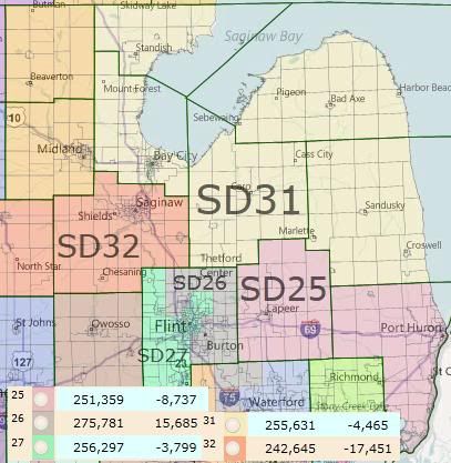
Look at Old-SD-32. That's a 58% Obama district in Republican hands. And it's not even one of the ones they captured in the 2010 wave. Old-SD-26 and Old-SD-31, on the other hand, are. I honestly don't think it's tenable to think that they can hold both a Saginaw-based district and a Bay City-based district for the duration, so my aim here was to create a new Democaratic vote sink while protecting the Republicans' two new incumbents -- which is feasible since the incumbent in Old-SD-32 is term-limited.
Also, Old-SD-26 is one of the two strangest looking districts on the map, with an apparent touch-point contiguity that isn't quite because of a surveying quirk. You'll probably need to look at the pdf map at the top to appreciate it, since it's spread over two images here.
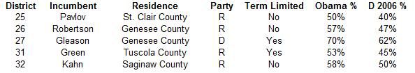
Proposed Map
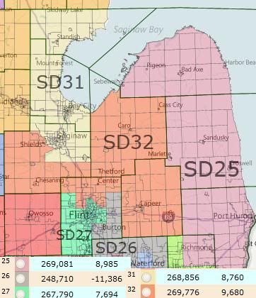
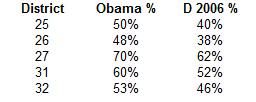
One of the main factors influencing this region of the map is actually back on the Macomb-Oakland map, where relative population growth pull both New-SD-25 and New-SD-27 southwards. I left the existing Democratic vote sink in New-SD-27 in place. I then reconfigured SD-31 into a new Democratic vote sink by stripping Saginaw out of Old-SD-32. New-SD-32 then gets to pick up Republican Lapeer County and some less-Democratic parts of Genesee County. Mike Green, the incumbent of Old-SD-31, now lives in New-SD-32. The benefit here for the Republicans is that New-SD-26 is vastly safer than its old incarnation.
It would be possible to swap the Genesee part of New-SD-26 and Lapeer County from New-SD-32 and still have valid districts. This would be a cleaner application of the redistricting guidelines and not too dissimilar from a partisan standpoint, but it would have doubled-up the Republican incumbents.
Democrats are now up a seat: -1 Detroit, +1 southern Macomb, +1 Saginaw/Bay City.
South Central and South Western Michigan
Current Map
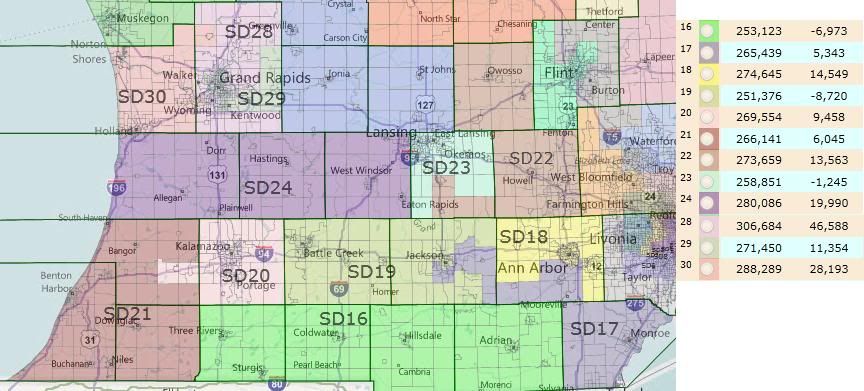
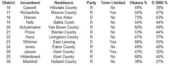
Another region, another two 60% Obama districts in Republican hands: Old-SD-20 and Old-SD-29. Note also the other of the two bizarrely shaped districts on the current map, Old-SD-17.
The region surrounding Grand Rapids has had a lot of population growth. New-SD-04 will be in that area somewhere.
Proposed Map
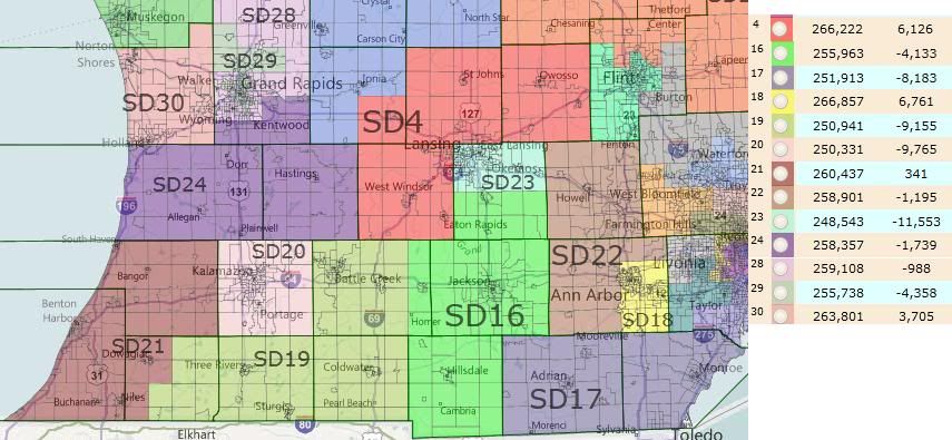
There's enough going on here that I'm going to take it district-by-district.
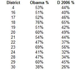
New-SD-16 is rearranged from a southern tier district to a Jackson-centric one. Its incumbent still lives here, and its partisanship is not significantly altered.
New-SD-17 drops its bizarre shape and becomes a nicely compact Lenawee and Monroe Counties district.
New-SD-18 shrinks a bit and manages to become even more Democratic.
New-SD-19 drops Jackson to pick up more conservative counties to the south, becoming 2 or 3 points more Republican.
New-SD-20 shrinks to just Kalamazoo County. This is problematic, because the incumbent lives the Van Buren County part of the old district. By my reading of the redistricting guidelines, the Republicans shouldn't draw her in, but they might anyway. There is absolutely no good reason for this district to be in Republican hands. (There is currently a bad reason involving the death of the Democratic candidate during the 2010 campaign and the rulings of the Republican Secretary of State related to that, but the district was Republican-held already.)
New-SD-21 stays more-or-less in place.
New-SD-22 swings south, taking in rural Washtenaw instead of Shiawassee. Partisanship is unaffected.
New-SD-23 shrinks, now taking in just the northern half of Ingham.
New-SD-24 takes in the western two thirds of Old-SD-24 and moves into burgeoning Kent County to make up the balance. Its incumbent lives in Eaton County, but the move into Kent caused it pick up the incumbent of Old-SD-29. This is an overly Republican district, but I couldn't figure out how to unpack it to their benefit.
New-SD-28 is now a slightly different assortment of Grand Rapid suburbs.
New-SD-29 uses the same strategy as the old version of packing as many red townships as possible in with Grand Rapids. I couldn't find anything that would significantly alter the partisanship of the district, though. If the Democrats are ever going to retake the senate, this is a district that they need to have fall to them soon.
New-SD-30 is now just Ottawa County and is the most Republican one in the state.
And finally, New-SD-04 takes shape to the north and west of Lansing. This is a much less safe district for its incumbent, who used to sit in Old-SD-24, but it should hold up well enough for the Republicans.
Running tally is still Democrats up a seat: -1 Detroit, +1 southern Macomb, +1 Saginaw/Bay City. The Democrats don't pick up anything here, although they really need to take Kalamazoo's New-SD-20 and Grand Rapids New-SD-29.
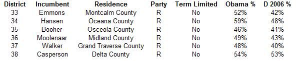
Northern Michigan
Current Map
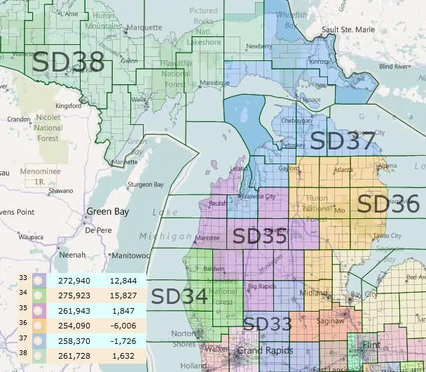
Sigh, Old-SD-34: a 59% Obama yet Republican-held district.
Upper Peninsula-based SD-38 is the final of the four Republican takeovers of 2010.
Proposed Map
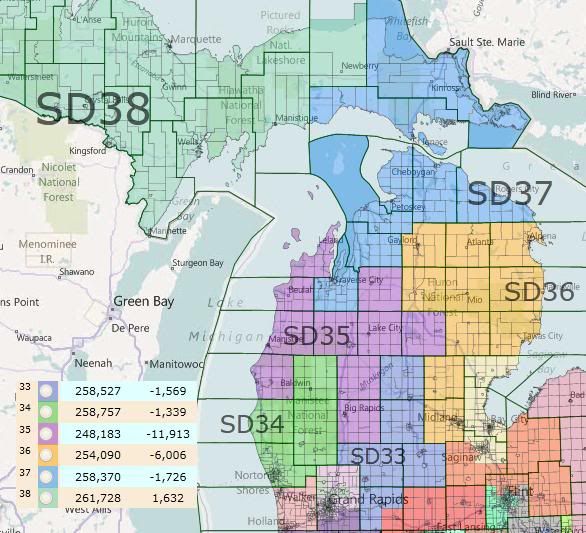
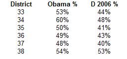
Anyway, these districts are kind of ugly, but they can't really be fixed up much because the Republican incumbents live in inconvenient locations relative to each other. New-SD-04 pushes New-SD-33 north one county into Clare. New-SD-34 solves its overpopulation problem by swapping Mason County for Lake County with New-SD-35. The remaining three districts were already valid districts that seemed like they would work for the Republican incumbents, so I left them alone.
Summary
Final tally: Democrats up a seat: -1 Detroit, +1 southern Macomb, +1 Saginaw/Bay City. Best Democratic opportunities after that: Kalamazoo's SD-20, Grand Rapids' SD-29, Muskegon's SD-34 and Marquette's SD-38. Taking all of those would mean a tied Senate, but we have some unfortunate inertia working against us in the west Michigan trio.
It might seem strange that a proposal for a Republican map would end up gaining the Democrats a seat, but the Republicans have a 2/3 majority right now. They can afford to cede back a seat to consolidate some of their gains from 2010, which this map does in the Thumb Region, at least.
Also, bonus discussion question: As best as I can figure, everyone currently serving in the state legislature will be term-limited out before the next redistricting cycle. Given that, how much do you think party leadership can lean on incumbents to accept districts that are bad for them as individuals but good in the long-term for the party? This is a more relevant question in dealing with the state house, and so looking towards eventually writing more diaries about that body's redistricting, I'm curious what people think.
