Note: This week’s diary continues the saga. Previous diaries were posted on 12/8 and 12/22 under the same title. I am also considering some recent and salient commentary from the DKos community about possibly cutting down the size of these missives. Hence, the dramatic (or not) conclusion will be addressed in next week’s diary. Thanks for the suggestion! As a reminder, the FYI’s are presented in the semblance of footnotes and can be read or skipped over, depending on how much or little the reader wants to read.
Prologue: Addressing an interesting legacy of the dam and lake snags to date, previous diaries cited basin constipation and contamination (both manmade and nature-caused), harmful ecological changes in the Grand Canyon’s riverine corridor, a rather sobering scenario that suggests ultimate dam failure caused by excessive sludge screwing up the dam works, and the continuing collateral damage caused by prolonged drought likely attributed to global warming. Combined there is a big question mark centered over Lake Powell since the 1990s. We can also address another matter, namely whether the Bureau of Reclamation’s initial plans the dam paying for itself remains valid in these later years. The following points are therefore noted and stated for the sake of clarification, including additional background previously not mentioned. (Continued after the fold.)
Glen Canyon Dam’s Cash Register Status: Given the momentous problems incurred since erecting the dam the federal government certainly has a lot on its shoulders. Consequently, various problems cited above typify a lot of muddled snags centered on both the dam and basin storage facility that are not easily resolved. There is also too much at stake that suggests a common platitude applauded by myriad vested business owners regarding the maintenance of a cash register facility––Lake Powell’s aquatic playground––just as the BOR manages its own cash register dam that makes it all happen. That summary follows. . .

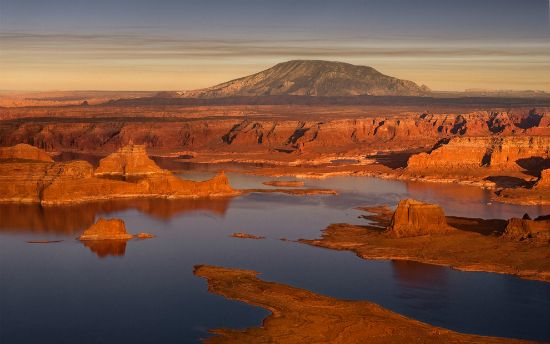
Erected in the late 1950s to create the reservoir as something multifunctional, the Glen Canyon Dam project was deemed an important hydroelectric facility that could generate power to supply large and small cities in this sector of the West. In actuality, only about 3 percent power is generated to the Four Corners region. Moreover, the dam was built and mainly used for water storage, and therefore not intended to generate electricity upon demand. To make money, this cash register dam has paid for itself by selling electricity to places like Phoenix, San Diego, Los Angeles, among other southwestern cities and towns, and with a proviso only when extra kilowatts were needed. Thus the kilowatt potential is there. Meanwhile, the functional role of Lake Powell comes down to the fact its basin stores water and abets the longevity of Lake Mead (i.e., cutting way down on its problem with silt aggradation).
(FYI: Implementing cash register dams was a concept developed early on by the BOR. Dams were therefore built solely for generating and selling electricity for a profit. Some, like the Glen Canyon Dam, were on-demand hydroelectric facilities (meaning, if the added kilowatts were needed, then its facility would generate the power and sell it). When, in the 1940s, Western States harvested their share of the Colorado River’s resources as fast as possible, the bounty wasn’t enough until Congress produced the means to satisfy such vested interests. Cash register dams also came under a term the BOR called, river-basin accounting, which somehow got mixed up with another term, river-basin planning. However, both ideas were designed to do two entirely different things. Because there was a need to show a profit for the bureau’s numerous large and small projects in operation, as well as those still scheduled to develop, the BOR was mandated by Congress to meet the objectives of its own economic feasibility requirements, something the agency could not do in the 1930s. Eventually, a cash register approach fused with a novel plan to meet its goals. By the 1940s, the bureau looked at the challenge it faced with a fresh perspective. In short, it considered an entire river basin as an integrated project that could derive a substantial income from various projects the agency managed, especially power-generating stations. The BOR could then fund other lesser-producing projects deemed non-economically feasible. With consolidation of garnered funds, and the coupling of planning and accountability for river-basin projects, commissioners in charge of these projects looked more confidently into the agency’s future and considered other rivers to be managed in a similar way.)
To Dredge Or Not To Dredge: This statement, of course, remains notable as it is a commonly conceived idea that might cleanse Lake Powell of its silt accumulation ailment. Remembering how someone once came up with an analogy of some 30,000 dump trucks pouring loads of sediment into the lake on a daily basis, that is, a combined inflow of three rivers funneling into the basin (not including the Dirty Devil River’s load that empties its muddy water into the Colorado River just below Cataract Canyon), there is no denying the fact rivers in this part of the country are doing exactly what nature intended: transporting a breakdown of sedimentary rock material, mostly sandstone clastic particles. Yet there are those who think or assume Lake Powell can take care of itself and on its own; that its basin is ‘plenty big enough’ to gorge itself with this stuff and function for hundreds of years. Unequivocally, this statement is erroneous as it is misleading.

As far as this particular subject matter goes, behold the proverbial elephant in the room scenario directly applicable to this setting. You can talk around it, behind it, in front of it, or pretend it’s not even there, yet Lake Powell’s elephant is always there. It’s just the case aggradation of such magnitude and mass has no trunk, no legs and no bulbous body. There is also something about this residual and continuing fallout that seems not to get as much airplay (public or private notice) these days. Hence, those unseen blobs are not stationary on the bottom of the basin. By a combined force of mass and gravity, scientists also know how hummocks formed from aggradation grow and continue moving down lake. Certainly, the migration of these congealed masses is almost negligible in the shorter view. Nevertheless, movement is detected (by sonar map comparison studies), where measured inches (in the longer view) eventually turn into feet, then feet into yards, and yards into miles.
Taking this hypothesis a bit farther, and no pun intended, the first diary related how Matilija Dam’s trouble was based on its own failure by filling up with too much sediment and not enough water. What wasn’t mentioned in that scenario is a serious secondary effect (actually, primary is the word for it) called overtopping. In short, where there is too much foreign mass in a basin’s environment and too little water, eventually a wide curtain of water flows down the face of a dam. This perilous condition may remind someone of a smaller version of Niagara Falls, but that’s not how dams are built to function. Overflowing basins simply exceed any dam’s specifications, thereby destroying the structure. The danger of water cascading over the crest of the dam can also be caused by too much water trapped inside the basin––a higher volume of water the dam was not originally designed to contain. Extreme weather conditions usually typifies the catalyst.
And here's the worst case scenario that might happen:

(FYI: As an example of just how quick some basins can be corrupted by aggradation, the Sanmexia Reservoir in central China was completed in 1960. But in just four years it was out of commission: the basin of water stored behind the dam had silted up completely. This waste of money and habitat also happens in India, Nepal, Africa and parts of Europe. Wherever the blight of overpopulation, deforestation, and excessive agriculture use occurs, dams erected in such regions are bound to have a shorter life expectancy.)
The Fickle Facts Of Climatic Wet and Dry Spells: Since the first diary was posted the plight of drought has been mentioned. Many times, in fact. When wet cycles are in effect, then ample precipitation means higher lake levels, starting in the spring, and usually lasting into mid-summer. Afterward, aridity rules once more and so lake levels drop. Even summer monsoonal rains tend to be miserly in contemporary times. Factor in an excessive demand for water throughout the Southwest and West and aquifers are not only lowered, but do not recharge. Ergo, Mother Nature no longer slakes the thirst of the land and life forms as happened in the not too distant past.
Sure, some people get excited and comforted when ample precipitation is nominal, at least when nature’s spigot is flowing the way it did before the drought set in. And sometimes nature really pours it on, literally. For instance, when the Rocky Mountain West records excessive and impressive snowfall. So, yes, there have been some decent winter seasons these past twenty or so years, but the Southwest has not seen the likes of unusually wet cycles, particularly in 1983. That epic flooding season and story is told elsewhere, where Lake Powell recorded such an excessive inflow of water the Glen Canyon Dam came that close (a snap of the fingers) to being overtopped, and therefore destroyed. (For this account, as well as other corroborative website information used in all three diaries, please see the URL references listed at the conclusion of next week’s diary.)
The gist of this banner year background of extreme precipitation relates how the Glen Canyon Dam did the unthinkable during what turned out to be a very frightening and intriguing saga: it started to destroy itself deep inside the intake tunnels. It was also a providential coincidence how a freak late spring snowstorm in the Rockies slowed the runoff process, which gave engineers and workers barely enough time to make emergency and temporary repairs (including installing wooden flash boards at the top of the spillway gates, while releasing millions of tons of water to help lower the momentous level of the lake). The point is dams will ultimately fail if there is too much water in the basin. Not only is there this fact of life to wonder and worry about (i.e., excessive water level), but also what happens when silt reaches the dam works and gums up the dam works. These unsettling problems are always listed on the status board under a banner title of something like “Emergency Protocols” (those just in case scenarios). And when protocols can't save the dam. . .surf's up and look out below!
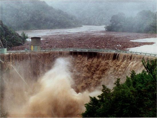
(FYI: In that 1983 scary spring scenario, the Glen Canyon Dam had exhibited poorly designed cavitating spillways and strong structural vibrations. Essentially, the interior of the dam was humming with ominous sounds and an imminent catastrophe was truly in the making––with no sure way of avoiding the disaster. There was, in short, an inability to bypass enough floodwater in the event of a major flood. Engineers, like workers who manned the front lines, will tell you they were dam, damn lucky to have prevented a worse case scenario. Indeed, after the proverbial storm had passed the spillways were redesigned to reduce or eliminate cavitation damage caused by the massive flooding by designing air slots inside the tunnels. Hence, the revision eliminated a possibility of the dam being completely undermined via erosion of the spillways, while effectively reducing the danger of the dam being over topped. Overtopping also abets erosion of the dam abutments. Siltation, degradation of concrete and reinforcements, spillway operational problems, and unstable dam abutments are also listed as key factors that may affect the safe operation of this or any other dam.)
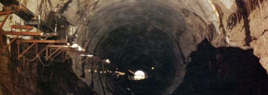
The worst damage was what you could not see from the outside. . .the intake tunnels and how cavitation just about toppled the entire structure:
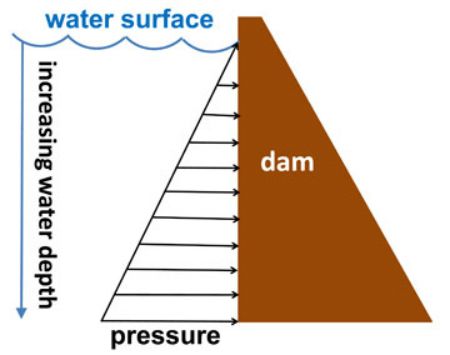
Besides the peril of overtopping, another way to topple a dam is an increased buildup of hydrostatic pressure. This essential fact of physics gets mentioned here as an added precaution against the previously mentioned migrating hummocks of silt that someday may get so far down-lake the overall mass ends up parked on this side of the dam wall. The admonishment comes down to this potential scenario: What happens if there is enough mass built up against the wall?
First, hydrostatic entails pressure. That pressure gradient is exerted by a fluid at equilibrium and at a given point within the fluid (think “water” for this example) caused by the force of gravity. Hydrostatic pressure thus increases in proportion to depth measured from the surface. Science explains the academic reason is due to the increasing weight of fluid exerting a downward force from above. (This axiom of Physics 101 is thus stated on the assumption a combination of pressures are directly nominal to the foundation––floor––and sides that are depicted as vectors of increasing magnitude with depth.) The so-called deadweight load of a concrete dam foundation is therefore distributed over the total area of the structure and indicated by vectors considered normal to the surface beneath the dam. Dam engineers will relate how such an assessment describing such magnitude denotes essentially static figures, and therefore depend only on the weight of the dam and the area of the foundation.
The point, as presented, highlights a grave and hypothetical synopsis how dams have failed before. Based on what was just described the potential for the Glen Canyon Dam’s collapse cannot be easily dismissed. Today’s drought, for instance, can turn into tomorrow’s deluge, that is, given the global swinging phenomenon, where anything is possible on any given day and in any given locale around the world. Moreover, aggradation in the water means the ratio of basin water to silt is obviously changing, and has changed rather quickly since this natural nuisance was first noticed (read “not taken for granted”) in the early 1990s. Somehow all the years that have gone by, and with silt accumulation steadily increasing, the bottom line should mean something is happening to this storage basin, I mean, way down there at the bottom of the lake and canyon. What do current sonar maps tell us about this? Alas, I am still trying to track this information down and so far such hydrology reports are proving to be evasive, at least discovering the most current findings. (So, yes, DKos readers, if any of you have an inkling where I might obtain the most current data, it would be greatly appreciated.)
On this note, there may be too much caution expressed tacitly or openly by dam engineers and hydrologists working the problem. Still, the potential death knell to this or any other basin is there. . .somewhere crawling or else stationary deep below the surface. . .and that bit of news is indeed warranted. Wouldn’t you think?
An Elementary Added Lesson, Watson, On Hydrostatic Pressure: Is a buildup of hydrostatic pressure behind the dam really a threat or just another drill aligned with one of those just in case scenarios and precautions? First, if hydrostatic pressure exceeds critical mass, then it remains a latent if scenario. Second, pressure distribution is modified by the materials of construction (either concrete or earthen dams) that have inherent strength, which may fail after some threshold stress has been exceeded. In other words, pressure exerted by water in the reservoir behind a dam is labeled hydrostatic and increase linearly with depth.
With these two points in mind, use your imagination and consider the ramifications of solid mass hummocks parked against the inside wall of the dam. That much weight and mass can surely topple the barrier. Moreover, a reinforced bulk is not only forced to hold back the water, but also added and accumulated weight the dam wasn’t designed to withstand. Although immense concrete edifices, like the Glen Canyon Dam, are built strong enough to restrain millions of cubic tons of water and withstand enormous pressure, a significant accretion might as well be some 10,000 pounds of dynamite. All it takes to ignite the stockpile is for sediment to get out of proportion with the amount of water stored in the basin (an obvious ratio imbalance). Then the dam and lake are rendered ineffectual.
Next, let’s adjust this equation for an understanding of more essentials of physics. Simply put the disproportioned water-to-silt will flip-flop. Hence, a process working to the heavier mass’s advantage. Once the material exceeds its critical mass overload a momentous hazard is therefore possible and predictable. Enormous pressure beyond the limits the dam was built to withstand can effortlessly snap its foundation like the proverbial twig. The potential of such an event happening is likely negligible, because when problems like this surface on a heavily monitored basin, like Powell, you can bet your last life vest engineers, with the government’s backing, will pull the plug and drain the lake. Until someone figures an ingenious way to filter sediment from the network of rivers funneling into the basin, Lake Powell denotes its own ticking time bomb.
Scooping The Poop As It Were: Let’s go back to the idea of dredging, that is, as a possible solution addressing the problem of constipation and aggradation fouling Lake Powell’s mousetrap. Actually, dredging is possible in places like Castle Rock (at the far end of the lake and close to Wahweap Marina). This approach has also been somewhat successful in the past. Yet it’s not possible in the upper sector of the lake, at least considering any attempt would likely prove useless. The fact is there is too much gunk to deal with––those alluvial fans at the mouths of each river are extensive. Basins, like Lake Powell, are also deep-water compounds. Compared to rivers like the Mississippi and Ohio, whose channels are frequently dredged, it’s much shallower water. Hence, the Goliath machines with the big buckets can easily get to the bottom and scrape away the muck. Again, that kind of efficiency isn’t going to happen here anytime too soon, if ever. Purging Lake Powell of its aggradation problem this late in the game would also likely exceed even the basin’s original lifespan estimate. Ergo, nature’s byproduct from this predominant sandstone country has been ahead of us all this time. Well, certainly ahead of the engineers and agency planners who decided damming this canyon was a safe bet for hundreds of years before such problems ever showed up. (If anyone out there is into seance, see if you can raise Dominy on an ethereal wavelength and see if his arrogance has abated in his afterlife. If so, he might agree with the poor planning motif that went into this operation.)
Sorry folks, I don't take collect ethereal calls. By the way, how's tricks with my blue jewel? Any problems yet?

(FYI: The Castle Rock Cut is a popular route on Lake Powell that allows boaters to travel between the Wahweap Marina and other destinations uplake. Traveling through the Castle Rock Cut saves about 12-miles to popular areas such as Rainbow Bridge, Padre Bay, and Warm Creek Bay. Due to long-term drought conditions, however, the Castle Rock Cut has not been usable since 2003. However, at rare times the lake level is higher and the cutoff is usable (note the operative word is “rare”). Then again, finding the most current information for the ‘cut’ is also evasive, at least for now. Hence, we must wait until the spring runoff and see just how much added water funnels into Lake Powell. Notably, whether the donation will be enough to revive this shortcut to uplake locales.)
Getting Around The Problem––Maybe? If one considers an earlier proposal that suggested making bypass channels for all three rivers, that costly and laborious idea has thus far not been embraced by the government. Besides, where would all that muck go once its filtered from those sources? Do the math: take a yearly average of at least 100 million tons and multiply it by, say, 100 years. How high and how long would this unremarkable (read “repugnant”) new landmark be? Ask yourself another question: Would you want to look at this mountain of residue if it was stored outside your backdoor? There are, after all, two essential mantras in life––yum and yuk––and this gummy and dull gray congealed material turned into a huge waste pile is indeed the latter mantra.
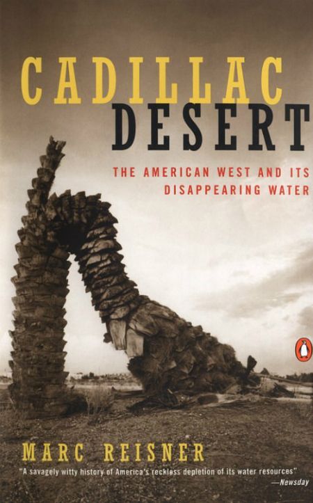
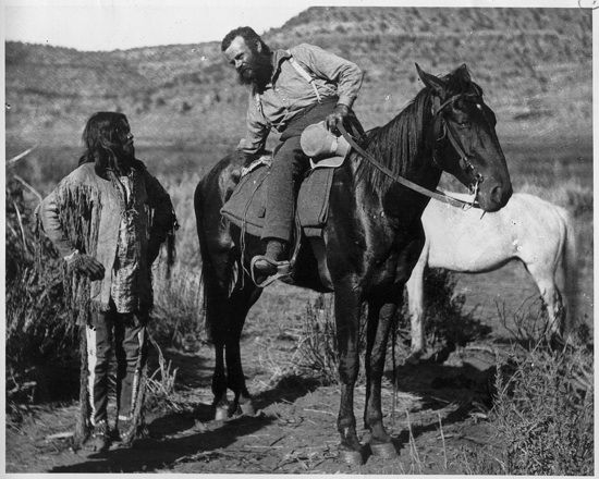
That Other Nagging Problem Needing To Be Addressed: I think at this point an historical overview of the West’s most precious elixir––water––is warrented. Part of what Marc Reisner accurately related in his tome Cadillac Desert is about this disappearing natural resource and how its liquid asset problems began around the turn of the century. In short, there has always been too much demand and too little supply for water and a huge demand placed on its value, both by industry and citizenry. This resource’s disappearance also suits the nature of dam construction and basin (water) storage. Reisner’s documented research on water waste and management is as forceful as it is prophetic. So was Major John Wesley Powell’s take on the aggressive development of the West. In short, he thought the government should be cautious with its 19th Century ambitious plans to develop the Western territory, specifically in view of what the 1862 Homestead Act allowed: 160 acres for those settlers who qualified. Powell thought the figure was much too low in view of the usually stingy annual precipitation the West was known for, at least what his explorer’s experience proved to be the case. He suggested, instead, increasing the acreage, substantially in fact.
In time, there was an Enlarged Homestead Act passed (1909), which targeted dryland farming, thus increasing the allotment to 320 acres. Then in 1916 the stock-raising Homestead Act was adopted and approved for settlers seeking 640 acres of public land for ranching purposes. Even this seeming generous increase was far less than what the visionary, Powell, proposed. (He envisioned at least 2,000 acres set aside for individual homestead settlement!) This intrepid explorer of the West, mainly its canyon country that he and his men added previously missing lines and data to cartographic maps, also sensed how rain in the West did not follow the plow. For one thing, the immensely large rain shadow effect created by the Sierra Nevada range keeps a watchful eye over a typically dry and vast territory reaching to the backdoor of the Rockies. Much of the Southwest is also desert terrain––typically a place of dry water. But Powell’s version of reality was no match for an Eastern embellished hype and imagination for coveted Western territory. For instance, the newspaper editor (and later a politician), Horace Greeley, created a major impetus for a post Civil War era mass emigration from the East to the Rockies and beyond. His popular slogan, “Go west, young man!” was encouraging, yet he was either misinformed by the intrigue and romance of the West, and maybe even a spin doctor type who wantonly passed misinformation to prospective settlers thinking they could manage to live off the land (which Powell conceded all along was typically dry).
Say, is it always this dry out here in the West? (Retort: "Put it this way, white eye; it ain't exactly Minnesota and the Land of 10,000 lakes!")
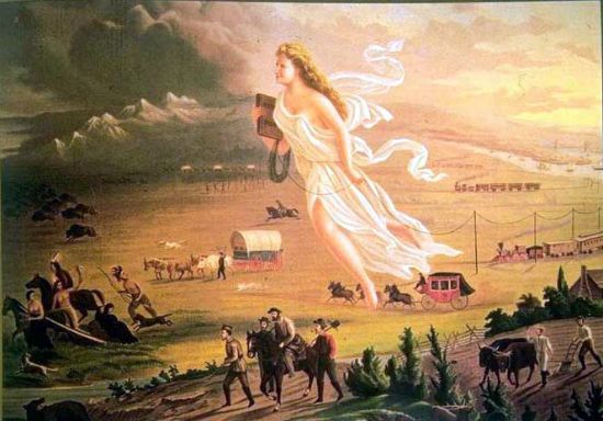
(FYI: The lure that initiated such a mass migration across the country’s various provinces, starting with the daring and dangers of the Great Plains, was a doctrine first coined by John O’Sullivan (in 1845), Manifest Destiny. His was also an endorsement based on a conviction of expansionism, American exceptionalism and Romantic nationalism. Combined, such a mindset touched on issues of religion, money, race, patriotism, and morality. But Greeley’s motivation was really the incentive to resettlement in the West (and by force, if necessary). Considering the hype on a fertile and wet territory boasted by potent backers of the Manifest Destiny doctrine, the political and civil promotion was more the case of Manifest Dryness. Likely, he, too, was impressed by John Gast’s 1872 painting the artist dubbed American Progress. An evocative and colorful depiction, the painting is an allegorical representation of the modernization of the new West for the new Americans headed there. The focus of the work depicts Columbia, who is a personification of the United States and leads civilization westward with American settlers beyond the 100th Meridian. Thus stringing telegraph wires on pole as she heads into this new territory (new for these Americans, that is). She also holds a school book in her hands. Gast has thereby revealed different stages of economic activity of the pioneers and highlighted by the changing forms of transportation. Combined with Sullivan’s Manifest Destiny this painting was indeed iconic as it was inspiring to pioneers.)
I have often wondered what visionaries, like Major Powell, would think if he were alive today. You know, one of those fantasized notions that rounds up this or that historical figure and pits him or her arguing their respective points with opponents. (If any of you remember Steve Allen’s peerless “Meeting of Minds” PBS series, he used such a dialectic approach to make his points with invited historical guests. That would also be my intention.) For the major’s first summary statement I am thinking of introducing him to Dominy, who naively named a big basin after him. Knowing how much Major Powell revered Glen Canyon I am thinking this feisty and bearded toothpick of a man-figure would likely introduce himself by a few left jabs (because he lost part of his right arm during the Civil War. Powell would also vindicate his stance on the predominant dryness of the West, as did Reisner, Abbey, Brower and so many others. Amen and A-women, too!)
Next week’s diary will fill in any other intentional blanks left out in these three initial postings, including a revelation of the most popular ideas submitted to save Lake Powell’s own death by drowning, only in silt aggradation. Perhaps by then I will even have my hands on the most current government facts and figures pertaining to lake conditions (particularly hydrology, aggradation and sonar map correlation, and the latest results from this year’s high flooding releases that try and fix the numerous problems downstream from the dam).
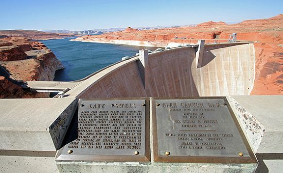
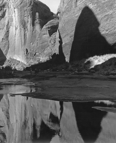
In Conclusion: At the Carl Hayden Visitor’s Center on the south side of the river (the Utah side), a modern structure much like a museum is a popular place where visitors gather. Here they are regaled with large panels of pictures depicting the before, during and after modification of Glen Canyon. The view of the dam beyond the veranda is nothing less than overwhelming; such monstrosities usually are given the engineering marvel of its design and features. There is also a lot of information about how it was built, even why this canyon was selected for one of many Colorado River dam sites (at least in those years this was the case). Yet for a relative few there is an uncanny and preternatural indifference about the overwhelming concrete facade rising from the floor of the smooth-faced gorge and its handsomely stained rock formations. Certainly, its profile is an imposing feat to behold––a massive wall of cement holding back a jumbo lake. For this reason, most people are utterly transfixed by the engineering achievement. And people come to learn how this engaging edifice anchored like a heavy foot in the way of a former wild river captured and corralled since the early 1960s. At times, and in select places, it’s quiet enough to hear a barely discernible drone of the gelded Colorado flowing out from underneath the towering fortification. Perhaps, too, the intermittent and discernible echo is merely the exhaling of the wind rising from those great depths, then hushed as though something unseen had just exhaled. Either way there is something mighty in the way of an inexplicable energy that one perceives isn’t just coming from the hum and frequency of the dam, itself.
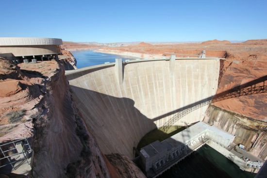
From observation posts seven hundred feet above the floor of the canyon, visitors watch and follow a gleaming tongue of water funnel its way downstream. With a lovely dark blue color on one side of the dam and emerald green on the other, the river runs clear and usually smooth. Today, even in hotter months, its relatively tapered artery issuing from below the base of the dam is like a liquefied glacier only in a meltdown phase. The river quickly narrows as it enters the winding corridor of an annex canyon. The Colorado is also on a long leash because it is a mandated controlled release, averaging between 9,000 and 11,000 cubic feet per second (c.f.s.). Funny thing is, the combination of the lake and dam spectacle makes some people think this part of the Upper Colorado was always this way; that the blue basin that laps along a shoreline the size of most Eastern states was always here. To try and suggest or prove otherwise is akin to impiety in the face of progress and ingenuity. Besides, the West needs its water reserve and there’s plenty of open space to go around for everyone, which is what too many people think is true.
What lessons we have learned, unlearned, and sometimes ignored from the iconic Glen Canyon-Lake Powell 1950s makeover is always subject to debate and following. Notably, the good, bad and ugly manifestations that have grown out of this environmental issue. As an issue, and more like a sobering statement serving the needs of Floyd Dominy’s vainglory has (by some accounts) turned utterly fraught, though his role in getting the dam erected has served as both a paean and a post apology for the native Glen Canyon before her drowning. True, that’s a loaded sentiment, and so is Lake Powell loaded with silt fallout that cannot be removed, that is, so far this appears to be the case. To offer a more straightforward answer to the question, the key words that comes to my mind is education and environmental awareness. Although there is no imminent government plans to dismantle the dam and drain the lake, hence the business and tourist interests of the region remain intact (for now), America’s policy entailing long range problems, be it something to do with the environment, the infrastructure of economy, endorsements for a healthier society (i.e., curbing the trend of obesity, stricter gun controls, immigration policies, to mention only some), all these mentionable subjects tend to forestall final action taken, that is, in a timely fashion. Behold the subject matter of these posted diaries that continue studying the problem or problems (as it were). On the other hand, the gridlock is not without a key. It appears the Glen Canyon-Lake Powell issue is indeed an illuminating and educational lesson for all of us. Plainly, we have tampered with nature’s design, and given all the planning that went into this affair I can think of another fitting Yiddish adage to close this diary: Man plans and God laughs. Simply exchange God for Nature and let’s not get into a heavy debate about Pantheism, Deism, or Transcendentalism and the like.
I hope you'll join me for the final installment to be posted next week. Meanwhile, pro and con intelligent commentary always welcomed.
Rich Holtzin
Albuquerque, NM
http://www.grandcanyon.org/...
